Waccamaw River facts for kids
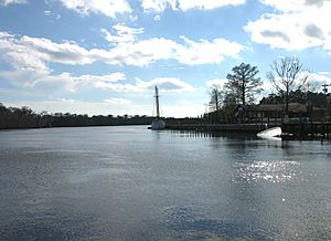
The Waccamaw River is a long river, about 140 miles (225 km) long. It flows through southeastern North Carolina and eastern South Carolina in the United States. This river helps drain an area of about 1,110 square miles (2886 km²). This area is along the coast between the two states. The river then flows into the Atlantic Ocean.
At its start, the Waccamaw is a slow-moving, blackwater river. It is surrounded by huge wetlands. Only small boats like canoes can travel here. Further down, the river has sandy banks and old plantation houses. It becomes an important path for boats. It flows mostly parallel to the coast.

Contents
Where Does the Waccamaw River Start?
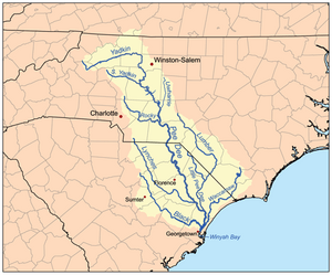
The Waccamaw River begins at Lake Waccamaw. This lake is a special type of oval-shaped wetland called a Carolina Bay. It is located in Columbus County, North Carolina. As the river flows downstream, it forms the border between Columbus and Brunswick Counties. It generally flows southwest, staying about 15 miles (24 km) away from the ocean.
The River's Journey
The Waccamaw River then enters South Carolina. It flows southwest through Horry County, passing by Conway. Near Burgess, the Great Pee Dee River joins it from the northwest. The Great Pee Dee River starts in north-central North Carolina.
The Waccamaw continues southwest. It gets very close to the ocean, only about five miles (8 km) away. This part of the river is a long, narrow tidal estuary. An estuary is where fresh river water mixes with salty ocean water. The long, narrow piece of land along the ocean, formed by the lower river, is called Waccamaw Neck. At Georgetown, the Black River (South Carolina) joins the Waccamaw from the north. The Waccamaw then turns sharply southeast. It enters the ocean at Winyah Bay. This bay is about five miles (8 km) north of where the Santee River meets the ocean.
The lower part of the Waccamaw River can be traveled by boat all the way to Conway. It has been an important trade route for the area since the 1700s. Before that, it was also very important for different Native American groups.
The lower part of the river in South Carolina is now part of the Atlantic Intracoastal Waterway. This is a fun route for boats. It connects to the Waccamaw River from the northeast at Bucksport, South Carolina.
In the 1800s, farmers grew a lot of rice on the lands along the lower Waccamaw River. This crop needed many workers. After the American Civil War, the way farming was done changed. This led to the rice farming industry becoming less common.
Amazing Animals and Plants
The large wetlands along the Waccamaw River are home to many different animals and plants. These include the tiny Carolina pygmy sunfish and the large American black bear.
The Waccamaw River's floodplain is covered by many types of forests. These include cypress-gum swamps and bottomland hardwood forests. The hardwood forests here are special in the Carolinas. They have many Atlantic white cedar and live oak trees. They also have common trees like laurel and overcup oak, and loblolly pine.
Protecting Nature
Some of this important natural area has been bought by The Nature Conservancy. This group works to protect nature. Land along the Waccamaw, lower Pee Dee, and Little Pee Dee rivers has been set aside to protect the animals and plants. More land is being bought for a new place called the Waccamaw National Wildlife Refuge. This refuge helps keep the river's unique environment safe for the future.
 | Delilah Pierce |
 | Gordon Parks |
 | Augusta Savage |
 | Charles Ethan Porter |


