Conway, South Carolina facts for kids
Quick facts for kids
Conway
|
|||||
|---|---|---|---|---|---|

Conway Downtown Historic District
|
|||||
|
|||||
| Nickname(s):
Historic Rivertown
|
|||||

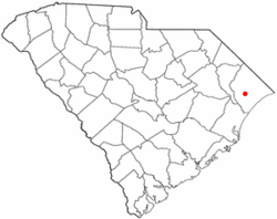
Location in South Carolina
|
|||||
| Country | United States | ||||
| State | South Carolina | ||||
| County | Horry | ||||
| Founded | 1732 | ||||
| Named for | General Robert Conway | ||||
| Area | |||||
| • Total | 25.41 sq mi (65.80 km2) | ||||
| • Land | 24.51 sq mi (63.47 km2) | ||||
| • Water | 0.90 sq mi (2.33 km2) 3.54% | ||||
| Elevation | 33 ft (10 m) | ||||
| Population
(2020)
|
|||||
| • Total | 24,849 | ||||
| • Estimate
(2023)
|
27,985 | ||||
| • Density | 1,013.96/sq mi (391.49/km2) | ||||
| Time zone | UTC−5 (EST) | ||||
| • Summer (DST) | UTC−4 (EDT) | ||||
| ZIP codes |
29526-29528
|
||||
| Area code(s) | 843, 854 | ||||
| FIPS code | 45-16405 | ||||
| GNIS feature ID | 1247370 | ||||
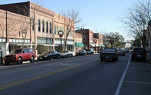
Conway is a city in South Carolina, United States. It is the main city and county seat of Horry County. In 2020, about 24,849 people lived there. This makes it one of the largest cities in the state.
Conway is part of the larger Myrtle Beach metropolitan area. It is also home to Coastal Carolina University. Many old buildings and places in Conway are listed on the National Register of Historic Places. This includes the City Hall building, which was designed by Robert Mills. He also designed the famous Washington Monument.
Since the 1980s, downtown Conway has been updated with new shops and restaurants. A special part of this area is the Riverwalk. It's a path along the Waccamaw River with places to eat and enjoy the view.
Contents
History of Conway
Conway is one of the oldest towns in South Carolina. When English colonists first settled here, they called the village "Kings Town." Later, they changed the name to "Kingston." The town started in 1732. It was part of a plan by Royal Governor Robert Johnson. The town was built on a high area overlooking the Waccamaw River.
For about 30 years, from the 1730s to the 1750s, King George II was very popular in the area. His birthday was a big holiday. However, the next king, King George III, quickly became unpopular. By the 1770s, most people in Kingston were English. There were also some Huguenots (French Protestants) and Scots-Irish people.
The English people in Kingston supported the rebels in Charleston. They were upset about "taxation without representation." This meant they were taxed without having a say in the government. When the Royal Governor left Charleston, the people of Kingston celebrated.
Many people from the area fought in the American Revolution. Small battles happened near Kingston. Francis Marion, known as the "Swamp Fox," had a camp close by. Horry County was created in 1801. Kingston became the county seat. The town's name was changed to "Conwayborough" to honor General Robert Conway, a local hero. In 1883, the name was shortened to "Conway."
Geography and Climate
Conway is located on the South Carolina Coastal Plain. It sits on the western side of the Waccamaw River. The city is about 14 miles (23 km) from the Atlantic Ocean. Major roads like U.S. Route 701, U.S. Route 501, and U.S. Route 378 pass through Conway.
The city covers about 25.41 square miles (65.80 km²). Most of this is land, with a small part being water. Downtown Conway is on the west bank of the Waccamaw River. The Waccamaw River flows south to the Pee Dee River and then to Winyah Bay.
Conway's Climate
Conway has a humid subtropical climate. This means it has mild winters and hot, humid summers. Plants like kale can grow well into the winter months. It's not unusual for temperatures to be in the 60s and 70s Fahrenheit (15-25°C) in December, January, and February. Spring usually starts in March.
| Climate data for Conway, South Carolina (1991–2020 normals, extremes 1893–2014) | |||||||||||||
|---|---|---|---|---|---|---|---|---|---|---|---|---|---|
| Month | Jan | Feb | Mar | Apr | May | Jun | Jul | Aug | Sep | Oct | Nov | Dec | Year |
| Record high °F (°C) | 83 (28) |
85 (29) |
96 (36) |
96 (36) |
101 (38) |
106 (41) |
105 (41) |
106 (41) |
105 (41) |
98 (37) |
89 (32) |
84 (29) |
106 (41) |
| Mean maximum °F (°C) | 74.6 (23.7) |
77.9 (25.5) |
82.9 (28.3) |
87.9 (31.1) |
93.0 (33.9) |
97.2 (36.2) |
98.7 (37.1) |
97.6 (36.4) |
93.5 (34.2) |
87.9 (31.1) |
81.4 (27.4) |
76.6 (24.8) |
100.1 (37.8) |
| Mean daily maximum °F (°C) | 58.1 (14.5) |
60.6 (15.9) |
68.0 (20.0) |
75.8 (24.3) |
82.6 (28.1) |
87.7 (30.9) |
90.8 (32.7) |
89.1 (31.7) |
84.8 (29.3) |
76.9 (24.9) |
68.2 (20.1) |
60.6 (15.9) |
75.3 (24.1) |
| Daily mean °F (°C) | 46.7 (8.2) |
49.4 (9.7) |
55.8 (13.2) |
63.8 (17.7) |
71.6 (22.0) |
78.2 (25.7) |
81.6 (27.6) |
80.2 (26.8) |
75.4 (24.1) |
65.9 (18.8) |
56.1 (13.4) |
49.6 (9.8) |
64.5 (18.1) |
| Mean daily minimum °F (°C) | 35.2 (1.8) |
38.1 (3.4) |
43.6 (6.4) |
51.9 (11.1) |
60.6 (15.9) |
68.7 (20.4) |
72.4 (22.4) |
71.2 (21.8) |
66.0 (18.9) |
54.8 (12.7) |
44.1 (6.7) |
38.6 (3.7) |
53.8 (12.1) |
| Mean minimum °F (°C) | 19.9 (−6.7) |
24.6 (−4.1) |
29.5 (−1.4) |
37.5 (3.1) |
46.8 (8.2) |
58.4 (14.7) |
65.3 (18.5) |
63.1 (17.3) |
52.8 (11.6) |
39.5 (4.2) |
31.1 (−0.5) |
22.3 (−5.4) |
17.6 (−8.0) |
| Record low °F (°C) | 4 (−16) |
11 (−12) |
12 (−11) |
22 (−6) |
34 (1) |
42 (6) |
51 (11) |
51 (11) |
41 (5) |
22 (−6) |
15 (−9) |
6 (−14) |
4 (−16) |
| Average precipitation inches (mm) | 4.28 (109) |
3.57 (91) |
3.76 (96) |
3.16 (80) |
3.33 (85) |
5.34 (136) |
6.89 (175) |
7.81 (198) |
6.00 (152) |
3.83 (97) |
3.21 (82) |
4.03 (102) |
55.21 (1,402) |
| Average precipitation days (≥ 0.01 in) | 9.4 | 7.6 | 8.0 | 6.9 | 8.1 | 10.6 | 10.7 | 10.9 | 8.1 | 6.4 | 6.6 | 8.0 | 101.3 |
| Source: NOAA (mean maxima/minima 1981–2010) | |||||||||||||
People in Conway
| Historical population | |||
|---|---|---|---|
| Census | Pop. | %± | |
| 1860 | 476 | — | |
| 1870 | 696 | 46.2% | |
| 1880 | 575 | −17.4% | |
| 1890 | 677 | 17.7% | |
| 1900 | 705 | 4.1% | |
| 1910 | 1,228 | 74.2% | |
| 1920 | 1,969 | 60.3% | |
| 1930 | 3,011 | 52.9% | |
| 1940 | 5,066 | 68.2% | |
| 1950 | 6,073 | 19.9% | |
| 1960 | 8,563 | 41.0% | |
| 1970 | 8,151 | −4.8% | |
| 1980 | 10,240 | 25.6% | |
| 1990 | 9,819 | −4.1% | |
| 2000 | 11,788 | 20.1% | |
| 2010 | 17,103 | 45.1% | |
| 2020 | 24,849 | 45.3% | |
| 2023 (est.) | 27,985 | 63.6% | |
| U.S. Decennial Census | |||
2020 Census Information
| Race | Num. | Perc. |
|---|---|---|
| White (non-Hispanic) | 15,042 | 60.53% |
| Black or African American (non-Hispanic) | 7,272 | 29.26% |
| Native American | 77 | 0.31% |
| Asian | 292 | 1.18% |
| Pacific Islander | 22 | 0.09% |
| Other/Mixed | 968 | 3.9% |
| Hispanic or Latino | 1,176 | 4.73% |
In 2020, the city had 24,849 people. There were 7,921 households and 4,881 families living in Conway.
Economy and Jobs
Many people work in Conway. Some of the main employers in the area include:
- New South Companies, Inc. (part of Canfor)
- Vulcan Materials Company
- AVX Corporation
The Grainger Generating Station was a power plant that used coal. It made electricity from 1966 until it closed in 2012.
Arts and Culture
Conway is home to the Kimbel Library and the Rebecca Randall Bryan Art Gallery. Both are located at Coastal Carolina University. The art gallery shows different art exhibits throughout the year.
Sports in Conway
The HTC Center is a large sports arena in Conway. It has 3,370 seats. It is on the campus of Coastal Carolina University. This center is where the university's men's and women's basketball teams play. The women's volleyball team also plays there.
Education in Conway
Most schools in Horry County are part of one public school system. It is called Horry County Schools. There is also a private school called Conway Christian School.
Conway has two main colleges:
- Coastal Carolina University
- Horry-Georgetown Technical College
There is also a branch of Webster University for graduate studies. The North American Institute of Aviation (NAIA) is a flight school located here. Conway also has a public library. It is a branch of the Horry County Memorial Library.
Media and News
You can find local news and media in Conway:
- The Chanticleer News is the student newspaper for Coastal Carolina University.
- Rivertown Radio is a local radio station.
- Horry Independent is a local newspaper.
Transportation
Getting Around Conway
Air Travel
Conway has a small airport called Conway–Horry County Airport (HYW). It is about 4 miles (6.4 km) west of the town.
Bus Services
The Coast Regional Transit Authority (RTA) serves a large part of Horry County. It used to be called the Waccamaw Regional Transit Authority. The main bus station is in downtown Conway.
Railroads
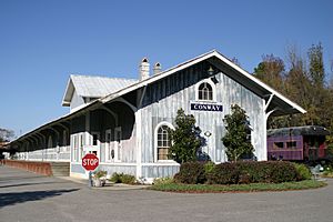
The R. J. Corman Railroad's Carolina Line is a short train line. It serves parts of North and South Carolina. Conway is on the branch that goes from Chadbourn, NC to Myrtle Beach, SC. The old Conway railroad depot is on this line. Today, the depot building is used as an office.
Famous People from Conway
- Bryan Edwards, an American football player
- William Gibson, an author known as the "father of cyberpunk" science fiction
- Junior Hemingway, a former football player for the Michigan Wolverines
- Tonka Hemingway, a football player for the South Carolina Gamecocks
- Grant Holmes, a professional baseball pitcher
- Kristy McPherson, a golfer on the LPGA Tour
- Hunter Renfrow, an American football player
- Sheri Reynolds, an author and professor
- Nick Shalosky, the first openly gay elected official in South Carolina
See also
 In Spanish: Conway (Carolina del Sur) para niños
 | Valerie Thomas |
 | Frederick McKinley Jones |
 | George Edward Alcorn Jr. |
 | Thomas Mensah |


