Brunswick County, North Carolina facts for kids
Quick facts for kids
Brunswick County
|
|||
|---|---|---|---|

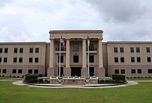
Brunswick County Courthouse
|
|||
|
|||

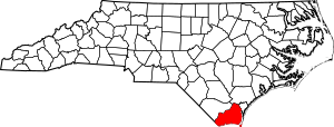
Location within the U.S. state of North Carolina
|
|||
 North Carolina's location within the U.S. |
|||
| Country | |||
| State | |||
| Founded | March 9, 1764 | ||
| Named for | Duchy of Brunswick-Lüneburg | ||
| Seat | Bolivia | ||
| Largest community | Leland | ||
| Area | |||
| • Total | 1,049.543 sq mi (2,718.30 km2) | ||
| • Land | 850.069 sq mi (2,201.67 km2) | ||
| • Water | 199.474 sq mi (516.64 km2) 19.00% | ||
| Population
(2020)
|
|||
| • Total | 136,693 | ||
| • Estimate
(2023)
|
159,964 |
||
| • Density | 160.80/sq mi (62.09/km2) | ||
| Time zone | UTC−5 (Eastern) | ||
| • Summer (DST) | UTC−4 (EDT) | ||
| Congressional district | 7th | ||
Brunswick County is a special area called a county in North Carolina, USA. It's the very last county at the southern tip of the state. In 2020, about 136,693 people lived here. The county is growing super fast! Back in 2000, there were only 73,143 people. Many new people are moving to places like Leland and Southport. The main town where the county government is located is Bolivia. It's a small town with only about 150 people.
Brunswick County is part of the Wilmington, NC Metropolitan Statistical Area. This means it's connected to the bigger Wilmington area for things like jobs and services. For a while, it was grouped with the Myrtle Beach area. But after some discussion, it was put back with Wilmington in 2023.
A big part of the county's money comes from tourism. People love to visit the beautiful beaches south of Cape Fear. Popular spots include Bald Head Island and Oak Island. Calabash is a town famous for its delicious fried seafood. You'll find many "Calabash-style" restaurants there. Also, because it's close to Cinespace Wilmington, Brunswick County is a popular place for filming movies and TV shows!
Contents
History of Brunswick County
The county was officially created in 1764. It was made from parts of Bladen County and New Hanover County. It got its name from an old port town called Brunswick Town. That town was named after King George I of England, who was also the Duke of Brunswick.
After Brunswick Town was destroyed during the American Revolutionary War, more people moved to the southern part of the county. The town of Smithville was started in 1805. Three years later, it became the county seat. Before the American Civil War, Brunswick County grew a bit. Many enslaved people were forced to work on farms, growing things like corn, cotton, and rice. By 1860, almost half of the county's population were enslaved people.
During the American Civil War, soldiers built Fort Anderson near Brunswick Town. This fort helped protect the Cape Fear River and the Port of Wilmington from attacks. Brunswick County didn't grow much in the late 1800s. Smithville was renamed Southport in 1887. In the 1930s, people started building along the county's beaches. Between 1955 and 1975, six beach communities became official towns.
Geography and Nature
Brunswick County covers about 1,049 square miles. Most of this is land, but about 199 square miles is water. This makes it the fourth-largest county in North Carolina by total area. The Brunswick River and the Cape Fear River connect the county to the Atlantic Ocean.
The Brunswick Nuclear Generating Station, a power plant, is located north of Southport.
Water Sources and Protected Areas
The main sources of underground water for Brunswick County are the surficial aquifer (for homes) and the Castle Hayne aquifer (for towns).
Brunswick County has many beautiful natural places and protected sites. These include:
- Bald Head Island Conservancy
- Bald Head Island Natural Area
- Bald Head Woods Maritime Forest Preserve
- Bird Island Reserve
- Brunswick County Botanical Garden
- Brunswick Nature Park
- Brunswick Town/Fort Anderson State Historic Site
- Ev-Henwood Nature Preserve
- Fort Caswell Historic District
- Green Swamp Game Land
- Green Swamp Preserve (part)
- Museum of Coastal Carolina
- Myrtle Head Savanna
- North Carolina Maritime Museum at Southport
- Oak Island Lighthouse
- Old Baldy Lighthouse and Smith Island Museum
- Orton Creek Preserve
- Zekes Island Estuarine Reserve Dedicated Nature Preserve (part)
- Zeke's Island Reserve (part)
Major Water Bodies
The county is home to many important rivers, creeks, and parts of the ocean:
- Alligator Creek
- Atlantic Ocean
- Brunswick River
- Cape Fear River
- Elizabeth River
- Frying Pan Shoals
- Intracoastal Waterway
- Lockwood Folly River
- Little River
- Long Bay
- North Lake
- Northeast Cape Fear River
- Onslow Bay
- Orton Pond
- Patricia Lake
- Saucepan Creek
- Shallotte River
- Town Creek
- Waccamaw River
Major Islands
Several islands are part of Brunswick County:
- Bald Head Island
- Bird Island
- Eagles Island
- Oak Island
Popular Beaches
Brunswick County is famous for its beautiful beaches:
Neighboring Counties
Brunswick County shares borders with:
- Pender County – to the north
- New Hanover County – to the east
- Columbus County – to the west-northwest
- Horry County, South Carolina – to the west
Main Roads
Many important roads run through Brunswick County:

 Future I-74
 I-140 / NC 140
 US 17
US 17
 US 17 Bus.
 US 17 Bus.
 US 74
US 74 US 76
US 76 US 421
 NC 87
NC 87 NC 130
 NC 130 Bus.
 NC 133
 NC 179
 NC 179 Bus.
 NC 211
 NC 904
 NC 906
Important Transportation
- Bald Head Island Ferry: A private boat service to Bald Head Island.
- Cape Fear Regional Jetport: A small airport near Oak Island.
- Military Ocean Terminal Sunny Point: A military port near Southport.
- Odell Williamson Municipal Airport: Another local airport.
- Southport–Fort Fisher Ferry: A ferry that connects to New Hanover County.
Population and People
| Historical population | |||
|---|---|---|---|
| Census | Pop. | %± | |
| 1790 | 3,071 | — | |
| 1800 | 4,110 | 33.8% | |
| 1810 | 4,778 | 16.3% | |
| 1820 | 5,480 | 14.7% | |
| 1830 | 6,516 | 18.9% | |
| 1840 | 6,255 | −4.0% | |
| 1850 | 7,272 | 16.3% | |
| 1860 | 8,406 | 15.6% | |
| 1870 | 7,754 | −7.8% | |
| 1880 | 9,389 | 21.1% | |
| 1890 | 10,900 | 16.1% | |
| 1900 | 12,657 | 16.1% | |
| 1910 | 14,432 | 14.0% | |
| 1920 | 14,876 | 3.1% | |
| 1930 | 15,818 | 6.3% | |
| 1940 | 17,125 | 8.3% | |
| 1950 | 19,238 | 12.3% | |
| 1960 | 20,278 | 5.4% | |
| 1970 | 24,223 | 19.5% | |
| 1980 | 35,777 | 47.7% | |
| 1990 | 50,985 | 42.5% | |
| 2000 | 73,143 | 43.5% | |
| 2010 | 107,431 | 46.9% | |
| 2020 | 136,693 | 27.2% | |
| 2023 (est.) | 159,964 | 48.9% | |
| U.S. Decennial Census 1790–1960 1900–1990 1990–2000 2010–2020 |
|||
Brunswick County has grown a lot! In 2020, there were 136,693 people living here. Most people are White (82.2%), followed by African American (8.4%). About 5.4% of the population is Hispanic or Latino.
In 2022, the average household had about 2.28 people. The average rent was about $1,187. Most homes (83.7%) are owned by the people living in them. Only about 8.5% of people live below the poverty line. Many people work in the county (48.8% employment rate). Also, 93.5% of adults have a high school diploma.
Many people in Brunswick County have English (15.1%), Irish (13.1%), or German (11.5%) backgrounds. The average age in the county is 57.6 years old. This is because many retired people are moving to Brunswick County. Between 2020 and 2023, Brunswick County had the fastest population growth in North Carolina.
Economy and Jobs
Because so many people are moving to Brunswick County, the economy is strong and growing. There are more and more jobs in places like restaurants and stores. Many retired people live here, so a lot of money comes from their investments and benefits like Social Security. Less than half of the people in the county work. Many of those who do work travel outside the county for their jobs.
Local Culture
The town of Calabash is famous across the country for its unique style of lightly-breaded fried seafood. The town of Navassa is a historic community. It was settled by people with Gullah heritage. Even though they have mixed with others, their history is still important.
Communities in Brunswick County
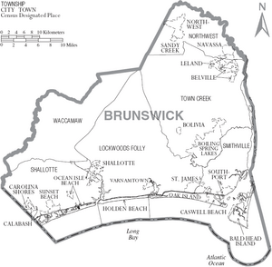
Brunswick County has 19 official towns and communities:
- Boiling Spring Lakes
- Northwest
- Southport
- Belville
- Bolivia (county seat)
- Calabash
- Carolina Shores
- Caswell Beach
- Holden Beach
- Leland (largest community)
- Navassa
- Oak Island
- Ocean Isle Beach
- Sandy Creek
- Shallotte
- St. James
- Sunset Beach
- Varnamtown
- Bald Head Island
Townships
These are larger areas within the county:
- Lockwoods Folly
- Northwest
- Shalotte
- Smithville
- Town Creek
- Waccamaw
Unincorporated Communities
These are smaller places that are not officially towns:
- Antioch
- Ash
- Batarora
- Bell Swamp
- Bishop
- Biven
- Bonaparte Landing
- Boone's Neck
- Bowensville
- Brunswick Station
- Camp Branch
- Cedar Grove
- Civietown
- Clairmont
- Coolvale
- Doe Creek
- Eastbrook
- Easy Hill
- Fort Caswell
- Grissettown
- Half Hell
- Longwood
- Maco
- Old Town
- Piney Grove
- Red Bug
- Sunset Harbor
- Supply
- Thomasboro
- Town Creek
- Winnabow
See also
 In Spanish: Condado de Brunswick (Carolina del Norte) para niños
 | Claudette Colvin |
 | Myrlie Evers-Williams |
 | Alberta Odell Jones |


