Columbus County, North Carolina facts for kids
Quick facts for kids
Columbus County
|
|||
|---|---|---|---|

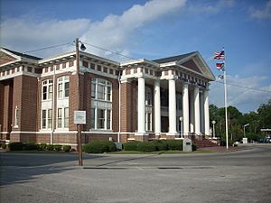
Columbus County Courthouse in Whiteville
|
|||
|
|||
| Motto(s):
"We are ready to grow with you."
|
|||

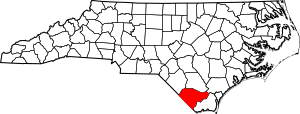
Location within the U.S. state of North Carolina
|
|||
 North Carolina's location within the U.S. |
|||
| Country | |||
| State | |||
| Founded | 1808 | ||
| Named for | Christopher Columbus | ||
| Seat | Whiteville | ||
| Largest community | Whiteville | ||
| Area | |||
| • Total | 955.00 sq mi (2,473.4 km2) | ||
| • Land | 938.12 sq mi (2,429.7 km2) | ||
| • Water | 16.88 sq mi (43.7 km2) 1.77% | ||
| Population
(2020)
|
|||
| • Total | 50,623 | ||
| • Estimate
(2023)
|
50,121 | ||
| • Density | 53.96/sq mi (20.83/km2) | ||
| Time zone | UTC−5 (Eastern) | ||
| • Summer (DST) | UTC−4 (EDT) | ||
| Congressional district | 7th | ||
Columbus County is a county in the southeastern part of North Carolina, a state in the United States. Its main town and county seat is Whiteville. In 2020, about 50,623 people lived here. This number was a bit lower than in 2010.
Contents
History
Early Times
Long ago, the Waccamaw people lived in the area that is now Columbus County. They were a Native American group. European explorers and settlers arrived in the 1500s.
Later, in the 1600s and 1700s, more English settlers came. Sadly, new diseases brought by Europeans caused many Native Americans to get sick. The Waccamaw and other tribes also faced conflicts like the Tuscarora War and Yamasee War. Many Tuscarora people moved north to New York. The Waccamaw people found safety in the Green Swamp area near Lake Waccamaw.
Colonial Days
When America was a British colony, Columbus County was part of a larger area called Bath Precinct. Over time, new counties like New Hanover and Bladen were formed. In 1764, Brunswick County was created. The area was mostly forests with few European settlers.
A botanist named William Bartram visited Lake Waccamaw in the 1730s. He wrote the first detailed descriptions of the plants and animals there. During the American Revolutionary War, some small battles happened in this area.
How the County Started
Columbus County was officially created on December 15, 1808. It was formed from parts of Bladen and Brunswick counties. This made it easier for people to do official business without traveling far. The county was named after Christopher Columbus.
In 1810, a town was planned on land owned by James B. White. This town became Whiteville in 1832 and was chosen as the county seat. The first courthouse and jail were built there in 1809.
Growth and Changes
When Columbus County was first formed, not many people lived there. A new brick courthouse was built in 1852. The county grew when a railroad was built in the 1860s. This railroad connected Whiteville to Wilmington. It helped the lumber and naval stores industries grow. Farmers also grew corn, wheat, cotton, and wool.
During the American Civil War, most white men from the county fought. The county did not see direct fighting. However, the war made it hard to find workers and food. After the war, the county's economy focused more on corn and cotton.
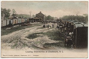
Later, in the late 1800s, tobacco became a new crop in Columbus County. By 1914, it was the main cash crop. Strawberries were also introduced in Chadbourn in 1895. By 1907, Chadbourn was a major strawberry producer worldwide. A new courthouse was built in 1914.
Recent Times
In the 1990s, the number of manufacturing jobs in Columbus County started to decrease. The county also lost many farming jobs. In 2018, Hurricane Florence caused a lot of damage to the area.
Geography
Columbus County is surrounded by other counties in North Carolina and South Carolina. It is the third-largest county in North Carolina by land area. The county has two main rivers: the Lumber River and the Waccamaw River. There are also several large lakes, including Lake Tabor and Lake Waccamaw.
A very special place in the county is the Green Swamp. This large area is home to unique and endangered plants, like the venus flytrap. It also has parts of the giant longleaf pine forest that used to cover the southeastern U.S.
Protected Areas
- Columbus County Game Land (part)
- Green Swamp Preserve (part)
- Honey Hill Hunting Preserve
- Juniper Creek Game Land (part)
- Lake Waccamaw State Park
- Lumber River State Park (part)
- North Carolina Museum of Natural Sciences at Whiteville
Major Water Bodies
- Cape Fear River
- Juniper Creek
- Lake Waccamaw
- Lumber River
- Waccamaw River
- White Marsh
Demographics
Population in 2020
In 2020, about 50,623 people lived in Columbus County. Most residents were white (59.3%), followed by black (28.6%). About 5.8% were Hispanic, and 3.4% were American Indian. Whiteville is the biggest town in the county.
Population Changes
|
||||||||||||||||||||||||||||||||||||||||||||||||||||||||||||||||||||||||||||||||||||||||||||||||||||||||
Between 2010 and 2020, the number of people living in Columbus County went down by about 7,475. This was a drop of 12.9%. Experts think the population might keep going down in the future.
Economy
The economy of Columbus County mainly relies on farming and manufacturing. Farmers grow crops like pecans, peanuts, soybeans, potatoes, and corn. They also raise cattle, poultry, and catfish. Factories in the county make things like textiles, tools, and plywood. They also produce household items such as doors, furniture, and windows.
International Paper is the biggest employer in the county. Many residents travel to other counties for work. The county is sometimes called "economically distressed" because it often has a higher unemployment rate than the rest of North Carolina.
Transportation
For air travel, Columbus County has the Columbus County Municipal Airport in Whiteville. A company called R.J. Corman Railroad Group operates a local train line in the county.
Major Highways

 Future I-74
 US 74
US 74
 US 74 Bus.
 US 76
US 76 US 701


 US 701 Bus. (Clarkton)


 US 701 Bus. (Tabor City)


 US 701 Bus. (Whiteville)
 NC 11
NC 11 NC 87
NC 87 NC 130
 NC 131
 NC 211
 NC 214
 NC 242
 NC 410
 NC 904
 NC 905
Education
Columbus County has two public school systems. One serves the rural areas of the county, and the other serves the city of Whiteville. Both are managed by elected school boards. The county also has six libraries. Southeastern Community College is located here too. In 2021, about 14.1% of adults in the county had a college degree or higher education.
Healthcare
Columbus County has one hospital, the Columbus Regional Healthcare System, in Whiteville. In 2022, a study ranked Columbus County 91st out of North Carolina's 100 counties for health outcomes. This was an improvement, as it had been ranked last from 2010 to 2015.
Communities
Cities
- Whiteville (the county seat and largest community)
Towns
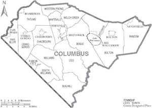
Townships
- Bogue
- Bolton
- Bug Hill
- Cerro Gordo
- Chadbourn
- Fair Bluff
- Lees
- Ransom
- South Williams
- Tatums
- Waccamaw
- Welch Creek
- Western Prong
- Williams
- Whiteville
Census-designated places
Unincorporated communities
- Acme
- Cherry Grove
- Evergreen
- Nakina
- Olyphic
- Pireway
- Riverview
- Sellerstown
- Williamson's Crossroads
See also
 In Spanish: Condado de Columbus para niños
 | Misty Copeland |
 | Raven Wilkinson |
 | Debra Austin |
 | Aesha Ash |


