Lumber River facts for kids
Quick facts for kids Lumber River |
|
|---|---|

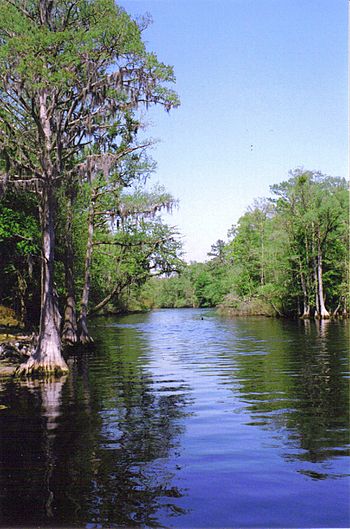
The Lumber River as seen from the boat launch at Princess Ann near Orrum
|
|

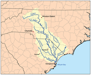
Map of the Pee Dee River watershed showing the Lumber River.
|
|
| Native name | Boise River |
| Other name(s) | Tributary to Little Pee Dee River |
| Country | United States |
| State | North Carolina South Carolina |
| County (South Carolina) | Dillon Horry Marion |
| County (North Carolina) | Columbus Hoke Robeson Scotland |
| City | Lumberton |
| Physical characteristics | |
| Main source | confluence of Buffalo Creek and Drowning Creek about 1 mile east of Oak Hill, North Carolina 225 ft (69 m) 34°57′43″N 079°21′58″W / 34.96194°N 79.36611°W |
| River mouth | Little Pee Dee River about 1 mile southwest of Nichols, South Carolina 39 ft (12 m) 34°11′44″N 079°09′56″W / 34.19556°N 79.16556°W |
| Length | 123.71 mi (199.09 km) |
| Basin features | |
| Progression | southeast then southwest |
| River system | Pee Dee River |
| Basin size | 1,749.86 square miles (4,532.1 km2) |
| Tributaries |
|
| Bridges | US 401, McGirt Gin Road, Red Springs Road (NC 71), Old Red Springs Road, Alma Road, Recreation Center Road, NC 711, Three Bridges Road, N Chicken Road, Lowe Road, Caton Road, US 301, W 5th Street, NC 41 + 72, S Chestnut Street, Hestertown Road, NC 72, Matthew's Bluff Road, Willoughby Road, NC 904, S Nichols Street (US 76-SC 9) |
| Type: | Scenic, Recreational |
| Designated: | September 25, 1998 |
The Lumber River is a 133-mile-long (214 km) river in North Carolina. It flows through the flat Coastal Plain region. Early European settlers called it "Drowning Creek." This name is still used for the river's starting point, called its headwater. The Lumber River officially begins at the border of Scotland and Hoke counties. It then flows all the way to the North Carolina-South Carolina border.
Once it crosses into South Carolina, the Lumber River joins the Little Pee Dee River. This river then flows into the larger Pee Dee River, also known as the Great Pee Dee River. Finally, all these combined waters flow into Winyah Bay and then into the Atlantic Ocean.
In 1989, the state of North Carolina recognized the Lumber River as a "Natural and Scenic River." It is also special because it's the only blackwater river in North Carolina to be named a National Wild and Scenic River by the Department of the Interior. Blackwater rivers get their dark color from decaying plants in the water. In 2010, people voted the Lumber River one of North Carolina's Ten Natural Wonders. This was part of an online contest to support protecting North Carolina's land and water.
Contents
River History
Ancient People Along the River
Scientists have found proof that different groups of Native Americans lived along the Lumber River for thousands of years. They found many old sites on high ground near the river. Even though farming has changed many of these places, lots of artifacts (old tools and items) and some fossils have been discovered. One amazing find was a dugout canoe made by ancient people. It is thought to be over 1,025 years old. You can see this ancient canoe at the Native American Resource Center at the University of North Carolina at Pembroke.
Most of the archaeological work in this area has happened in Robeson County. So far, 429 archaeological sites have been found there. These sites show signs of different time periods, from the very first people (Paleo-Indian) to more recent times after Europeans arrived.
Before Europeans came, tribes like the Iroquoian, Siouan, and Carolina Algonquian-speaking peoples lived in this region. Experts have found 47 important sites. Twenty of these are special enough to be added to the National Register of Historic Places.
The River's Name Changes
When English surveyors first explored the area, they called the river "Drowning Creek." In 1749, British records showed the river as a part of the Little Pee Dee River. But in 1809, the state of North Carolina decided to change the river's name to "Lumber River." They likely did this to celebrate the busy lumber industry in the area. The river was very important for moving logs. They wanted a name that sounded more positive than "Drowning Creek."
Lumber Industry in the 1800s
In the late 1700s and throughout the 1800s, the lumber and naval stores industries were very important. Naval stores are products like turpentine and tar, used for building and maintaining ships. The Lumber River became a key route for floating long, 100-foot logs downstream. These logs went to the seaport of Georgetown, South Carolina. The town of Lumberton, North Carolina was a major center for cutting timber and making turpentine. You can still see old bridge parts and dock supports along the river. These remind us how vital the lumber industry was to this whole region.
River Recreation
Today, the Lumber River is a popular place for outdoor fun in North Carolina. Many people enjoy active outdoor activities and festivals here. Some popular things to do include:
- Canoeing and boating
- Fishing and hunting
- Picnicking and camping
- Studying nature and swimming
- Biking and jogging
- Looking for fossils and old artifacts
Lumber River State Park
A large part of the Lumber River and its nearby land is protected as Lumber River State Park. This park covers 9,874 acres of land and 115 miles of the river. You can access the park for fun activities at two main spots: Princess Ann Access in the south and Chalk Banks Access in the north. Chalk Banks is near the town of Wagram.
There are 24 places along the Lumber River where you can launch a boat to explore the park. The entire river is open for fishing. You can often catch fish like black crappie, largemouth bass, catfish, and redbreast sunfish. Remember, all anglers (people who fish) need a valid fishing license. They must also follow the rules set by the North Carolina Wildlife Resources Commission.
Nine simple camping spots are available at the Princess Ann section of the park. These are located between Orrum and Fair Bluff. Each campsite is designed for up to 6 people. They have a picnic table, a grill, a lantern holder, a trash can, and a fire ring. Princess Ann also has several hiking trails and picnic areas. Many towns and counties also have parks along the Lumber River.
At the Chalk Banks Access Area in Scotland County, there are fourteen individual campsites for families. Each site has a table, a lantern holder, a trash can, and a fire pit. You can also find special campsites that you can only reach by canoe.
Local Wildlife
The Lumber River is home to many different animals and plants. One unique fish found here is the Semotilus lumbee. This fish, also known as the sandhills chub, lives only in the sandhills region where the Lumber River flows.
Other special creatures live around the Lumber River too. These include the Megathymus yuccae, which is a type of giant yucca skipper butterfly. Also, the Leuconotopicus borealis, or red-cockaded woodpecker, lives in the habitats around the Lumber River. These species are found only in certain areas, making the Lumber River a very important place for them.
 | Sharif Bey |
 | Hale Woodruff |
 | Richmond Barthé |
 | Purvis Young |

