
Georgetown, South Carolina facts for kids
Quick facts for kids
Georgetown, South Carolina
|
||
|---|---|---|

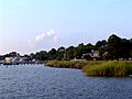
Georgetown harbor
|
||
|
||

Location in Georgetown County and the state of South Carolina.
|
||
| Country | United States | |
| State | South Carolina | |
| County | Georgetown | |
| Incorporated | 1729 | |
| Area | ||
| • Total | 7.59 sq mi (19.65 km2) | |
| • Land | 6.99 sq mi (18.11 km2) | |
| • Water | 0.59 sq mi (1.54 km2) | |
| Elevation | 18 ft (5 m) | |
| Population
(2020)
|
||
| • Total | 8,403 | |
| • Density | 1,201.80/sq mi (464.02/km2) | |
| Time zone | UTC−5 (EST) | |
| • Summer (DST) | UTC−4 (EDT) | |
| ZIP codes |
29440, 29442
|
|
| Area code(s) | 843, 854 | |
| FIPS code | 45-28870 | |
| GNIS feature ID | 1247888 | |


Georgetown is a historic city in the state of South Carolina, USA. It is the third oldest city in the state. Georgetown is also the main town of Georgetown County.
The city is located in the South Carolina Lowcountry, a coastal region. It sits on Winyah Bay, where four rivers meet: the Black, Great Pee Dee, Waccamaw, and Sampit rivers. Because of its location, Georgetown is the second largest seaport in South Carolina. It handles a lot of materials each year.
Long ago, Georgetown was a busy center for growing indigo and rice. Later, the timber industry also became very important.
Contents
Georgetown's Location and Landscape

Georgetown is found at 33°22′3″N 79°17′38″W / 33.36750°N 79.29389°W.
The city covers about 7.5 square miles (19.5 square kilometers). Most of this area is land, but about 0.6 square miles (1.6 square kilometers) is water.
Winyah Bay was formed when the coastline sank or the ocean rose. This created a "drowned coastline." The river valleys were flooded, which made a great spot for a harbor. This might have happened when glaciers melted at the end of the last ice age.
Several main roads meet in the center of Georgetown. These include U.S. Routes 17, 17A, 521, and 701. For example, US 17 goes southwest to Charleston and northeast to Myrtle Beach.
People of Georgetown
| Historical population | |||
|---|---|---|---|
| Census | Pop. | %± | |
| 1850 | 1,628 | — | |
| 1860 | 1,720 | 5.7% | |
| 1870 | 2,080 | 20.9% | |
| 1880 | 2,557 | 22.9% | |
| 1890 | 2,895 | 13.2% | |
| 1900 | 4,138 | 42.9% | |
| 1910 | 5,530 | 33.6% | |
| 1920 | 4,579 | −17.2% | |
| 1930 | 5,082 | 11.0% | |
| 1940 | 5,559 | 9.4% | |
| 1950 | 6,004 | 8.0% | |
| 1960 | 12,261 | 104.2% | |
| 1970 | 10,449 | −14.8% | |
| 1980 | 10,144 | −2.9% | |
| 1990 | 9,517 | −6.2% | |
| 2000 | 8,950 | −6.0% | |
| 2010 | 9,163 | 2.4% | |
| 2020 | 8,403 | −8.3% | |
| U.S. Decennial Census | |||
Population in 2020
In 2020, there were 8,403 people living in Georgetown. There were 3,649 households and 2,256 families in the city.
The people living in Georgetown in 2020 included:
| Race | Number of People | Percentage |
|---|---|---|
| White (not Hispanic) | 3,387 | 40.31% |
| Black or African American (not Hispanic) | 4,342 | 51.67% |
| Native American | 9 | 0.11% |
| Asian | 57 | 0.68% |
| Pacific Islander | 8 | 0.1% |
| Other/Mixed | 191 | 2.27% |
| Hispanic or Latino | 409 | 4.87% |
Population in 2010 and 2000
In 2010, Georgetown had 9,163 people. This was a small increase from the 8,950 people in 2000.
In 2000, about 33% of households had children under 18. About 38% were married couples. The average household had 2.55 people.
The median age in the city was 35 years old. About 28.6% of the population was under 18.
Georgetown's History

Early Settlements and Beginnings
Some historians believe that American history started here in 1526. The Spanish tried to create a colony called San Miguel de Gualdape. They brought enslaved people from Africa. This colony failed because of sickness and because the enslaved people sought freedom by joining the local Cofitachiqui Indians.
After the English settled Charles Town in 1670, they began trading with Indians. These trading posts soon grew into settlements.
In 1721, English residents asked to create a new church area, Prince George, Winyah. In 1734, this area was divided. The new town of Georgetown was then part of Prince George Parish, Winyah.
In 1729, Elisha Screven designed the layout for Georgetown. He planned the city in a grid pattern of four by eight blocks. This original grid is now a historic district. It still has the first street names and many old homes.
The Indian trade later slowed down. Planters then started growing indigo and rice as main crops. They used enslaved labor, mostly people brought from Africa. Growing these crops made a lot of money. In 1757, the Winyah Indigo Society opened the first public school for white children in the area.
During the American Revolution, two Georgetown planters, Thomas Lynch Sr. and Thomas Lynch Jr., signed the Declaration of Independence. Georgetown was an important port for supplying General Nathanael Greene's army. Francis Marion, known as the "Swamp Fox," led many guerrilla attacks nearby.

The Antebellum Period and Rice Plantations

After the American Revolution, rice became the most important crop. It was grown in the swampy areas along the rivers. Enslaved people built large earthworks, like dams and canals, to water and drain the rice fields. Many large rice plantations were built around Georgetown.
By 1840, Georgetown District produced almost half of all the rice in the United States. It became the world's largest port for exporting rice. The money from rice made some European-American planters very rich. They built grand homes and lived a comfortable life. This lifestyle, built on the labor of thousands of enslaved people, lasted until 1860.
Joshua John Ward, who owned over 1,000 enslaved people, lived in Georgetown. Many old plantations are still standing today, like Mansfield Plantation. Joshua Ward's main plantation, Brookgreen Plantation, is now part of the Brookgreen Gardens park.
Civil War and After
During the Civil War, a Confederate fort and two camps were near Georgetown. Fort Ward was used in 1861 but was later left empty.
After the Civil War, during the Reconstruction Era, Georgetown and its county faced hard times. The rice crops failed for several years. This was due to a lack of money, bad weather, and changes in how labor was managed after slavery ended. Many formerly enslaved people wanted to farm for themselves. Rice continued to be grown until about 1910, but not as much as before.
By 1900, the area's economy shifted to wood products. Several lumber mills opened on the Sampit River. The Atlantic Coast Lumber Company had the largest lumber mill on the East Coast in Georgetown.
Georgetown in the 20th Century

Around 1905, Georgetown was at its busiest as a lumber port.
In the early 1900s, Georgetown began to modernize. The city added electricity, telephone service, and sewer systems. Some streets were paved, and new banks and a public school were built. The US government also built a nice post office and customs house.
Like many cities, Georgetown struggled during the Great Depression. The Atlantic Coast Lumber Company went out of business, leaving many people without jobs. In 1936, the Southern Kraft Division of International Paper opened a large mill. By 1944, it was the biggest paper mill in the world.
In September 1989, Hurricane Hugo caused major damage to Georgetown. The city experienced very strong winds and a powerful storm surge.
Georgetown Today
In recent years, Georgetown's economy has become more varied. A steel mill was built here in 1973. It closed in 2003 but later reopened under ArcelorMittal. However, it closed permanently in 2015.
Now, Heritage tourism is a growing business. Many people also choose to retire in this area because of its beaches, old plantations, and pleasant weather.
Historic Places to Visit
The Georgetown Historic District has over fifty homes, public buildings, and sites listed on the National Register of Historic Places.
Other historic sites in the area include:
- Annandale Plantation
- Arcadia Plantation
- Battery White
- Belle Isle Rice Mill Chimney
- Beneventum Plantation House
- Black River Plantation House
- Brookgreen Gardens
- Chicora Wood Plantation
- Fairfield Rice Mill Chimney
- Friendfield Plantation
- Georgetown Light
- Hobcaw Barony
- Hopsewee
- Keithfield Plantation
- Mansfield Plantation
- Milldam Rice Mill and Rice Barn
- Minim Island Shell Midden (38GE46)
- Nightingale Hall Rice Mill Chimney
- Old Market Building
- Pee Dee River Rice Planters Historic District
- Prince George Winyah Episcopal Church
- Joseph H. Rainey House
- Rural Hall Plantation House
- Weehaw Rice Mill Chimney
- Wicklow Hall Plantation
- Winyah Indigo School

Education
Georgetown High School is located in Georgetown. The city also has a public library, which is part of the Georgetown County Library system.
Famous People from Georgetown
- Anna Peyre Dinnies (1807–1886), a poet and writer.
- Jumpy Geathers, a football player who won two Super Bowls.
- Robert ”Dab” Geathers Sr., an NFL football player and Jumpy's older brother.
- Robert Geathers Jr., NFL football player (Cincinnati Bengals), son of Robert Geathers Sr.
- Clifton Geathers, NFL football player for various teams, son of Robert Geathers Sr.
- Kwame Geathers, NFL football player for various teams, son of Robert Geathers Sr.
- Clayton Geathers, NFL football player (Indianapolis Colts), nephew of Robert and Jumpy Geathers.
- Donovan Richard, NFL football player (Jacksonville Jaguars).
- Tyrell Richard, US track runner and medalist, younger brother of Donovan Richard.
- Melissa Jefferson, a sprinter and 2024 Summer Olympics gold and bronze medalist.
- Marley Canteen, singer, songwriter, social media star, photographer, and LGBTQ activist.
- Dasean Jones (born 1978), a United States district judge.
- Ruston Kelly, a singer-songwriter.
- Joseph Rainey (1832–1887), a politician and the first African-American member of the U.S. House of Representatives.
Images for kids
-
Looking at Georgetown from the point in East Bay Park
See also
 In Spanish: Georgetown (Carolina del Sur) para niños
