Marion County, South Carolina facts for kids
Quick facts for kids
Marion County
|
|||
|---|---|---|---|

|
|||
|
|||
| Motto(s):
"It's just right!"
|
|||

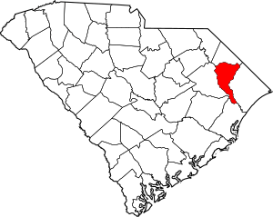
Location within the U.S. state of South Carolina
|
|||
 South Carolina's location within the U.S. |
|||
| Country | |||
| State | |||
| Founded | 1798 | ||
| Named for | Francis Marion | ||
| Seat | Marion | ||
| Largest community | Marion | ||
| Area | |||
| • Total | 494.17 sq mi (1,279.9 km2) | ||
| • Land | 489.37 sq mi (1,267.5 km2) | ||
| • Water | 4.80 sq mi (12.4 km2) 0.97% | ||
| Population
(2020)
|
|||
| • Total | 29,183 | ||
| • Estimate
(2023)
|
28,508 |
||
| • Density | 59.0546/sq mi (22.8011/km2) | ||
| Time zone | UTC−5 (Eastern) | ||
| • Summer (DST) | UTC−4 (EDT) | ||
| Congressional district | 7th | ||
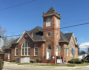
Marion County is a county located in the coastal plain of South Carolina, a state in the United States. In 2020, about 29,183 people lived here. The main town and county seat (where the county government is) is Marion. Many different groups of people live in Marion County, making it a very diverse place.
Contents
History of Marion County
Long ago, in the 1600s, European traders came to the Carolinas. They settled along the Pee Dee River, including a quiet area called Sandy Bluff. They traded with Native American tribes like the Choctaw and Chickasaw.
After the American Revolutionary War, in 1785, this area was organized by European Americans. It was first called Liberty County. But just four years later, it got a new name: Marion County. This name honors Brigadier General Francis Marion, a famous hero from the Revolutionary War. He was known as the "Swamp Fox" because he was very clever in battle.
In 1910, a part of Marion County was separated to form a new county called Dillon County.
Geography of Marion County
Marion County covers about 494 square miles. Most of this area, about 489 square miles, is land. The rest, about 5 square miles, is water.
Protected Natural Areas
Marion County has special places that are protected to keep nature safe.
- Waccamaw National Wildlife Refuge (part of it is in Marion County)
- Little Pee Dee Heritage Preserve/Wildlife Management Area
- Marsh Wildlife Management Area
- Woodbury Wildlife Management Area
Major Rivers and Swamps
Several important water bodies flow through Marion County:
- Cud Swamp
- Great Pee Dee River
- Lumber River
- Maidendown Swamp
- Waccamaw River
Neighboring Counties
Marion County shares its borders with several other counties:
- Dillon County to the north
- Horry County to the east
- Georgetown County to the south
- Williamsburg County to the southwest
- Florence County to the west
Main Roads and Highways
Many important roads help people travel through Marion County:
 Future I-73
 US 76
US 76 US 301
 US 378
 US 501


 US 501 Bus.
 SC 9
SC 9 SC 38
SC 38 SC 41
SC 41


 SC 41 Alt.
 SC 57
SC 57 SC 576
 SC 908
 SC 917
Population of Marion County
| Historical population | |||
|---|---|---|---|
| Census | Pop. | %± | |
| 1800 | 6,914 | — | |
| 1810 | 8,884 | 28.5% | |
| 1820 | 10,201 | 14.8% | |
| 1830 | 11,208 | 9.9% | |
| 1840 | 13,932 | 24.3% | |
| 1850 | 17,407 | 24.9% | |
| 1860 | 21,190 | 21.7% | |
| 1870 | 22,160 | 4.6% | |
| 1880 | 34,107 | 53.9% | |
| 1890 | 29,976 | −12.1% | |
| 1900 | 35,181 | 17.4% | |
| 1910 | 20,596 | −41.5% | |
| 1920 | 23,721 | 15.2% | |
| 1930 | 27,221 | 14.8% | |
| 1940 | 30,107 | 10.6% | |
| 1950 | 33,110 | 10.0% | |
| 1960 | 32,014 | −3.3% | |
| 1970 | 30,270 | −5.4% | |
| 1980 | 34,179 | 12.9% | |
| 1990 | 33,899 | −0.8% | |
| 2000 | 35,466 | 4.6% | |
| 2010 | 33,062 | −6.8% | |
| 2020 | 29,183 | −11.7% | |
| 2023 (est.) | 28,508 | −13.8% | |
| U.S. Decennial Census 1790–1960 1900–1990 1990–2000 2010 2020 |
|||
In 2020, the census showed that 29,183 people lived in Marion County. There were 11,600 households and 7,532 families.
Most people in the county are African American (about 56%). White people make up about 38% of the population. Other groups include Native American, Asian, and people of mixed backgrounds. About 2.4% of the population is Hispanic or Latino.
In 2010, the average household had about 2.5 people. The average family had about 3 people. The median age of people living in the county was about 39.9 years old.
Economy of Marion County
In 2022, the total value of all goods and services produced in Marion County was about $728.2 million. This is like the county's total income.
Some of the biggest employers in Marion County include well-known companies. These are Coca-Cola Consolidated, the city of Mullins, Domtar (a paper company), Goodyear Tire and Rubber Company, and Walmart. These businesses provide many jobs for the people living in the county.
Many people in Marion County work in healthcare, social assistance, retail, and transportation. The average yearly wage across all jobs in the county was about $42,496 in late 2023.
Communities in Marion County
Marion County has several towns and communities where people live.
Cities
Towns
Census-designated places
These are areas that are like towns but are not officially incorporated as cities or towns.
Other Unincorporated Communities
These are smaller communities that are not officially part of a city or town.
- Ariel Crossroad
- Brittons Neck
- Friendship
- Gresham
- Temperance Hill
See also
 In Spanish: Condado de Marion (Carolina del Sur) para niños
 | DeHart Hubbard |
 | Wilma Rudolph |
 | Jesse Owens |
 | Jackie Joyner-Kersee |
 | Major Taylor |


