Marion, South Carolina facts for kids
Quick facts for kids
Marion, South Carolina
|
|||
|---|---|---|---|
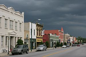
Main street, Marion SC
|
|||
|
|||
| Nickname(s):
"The Swamp Fox City"
|
|||
| Motto(s):
"Where History and Hospitality Greets You"
|
|||
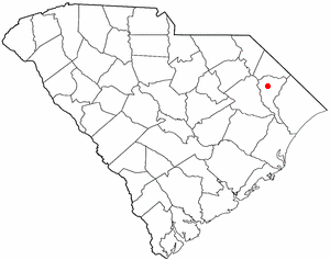
Location of Marion in South Carolina
|
|||
| Country | United States | ||
| State | South Carolina | ||
| County | Marion | ||
| Area | |||
| • Total | 4.48 sq mi (11.59 km2) | ||
| • Land | 4.48 sq mi (11.59 km2) | ||
| • Water | 0.00 sq mi (0.00 km2) | ||
| Elevation | 72 ft (22 m) | ||
| Population
(2020)
|
|||
| • Total | 6,448 | ||
| • Density | 1,440.25/sq mi (556.11/km2) | ||
| Time zone | UTC−5 (EST) | ||
| • Summer (DST) | UTC−4 (EDT) | ||
| ZIP code |
29571
|
||
| Area code(s) | 843, 854 | ||
| FIPS code | 45-44575 | ||
| GNIS feature ID | 1246533 | ||
| Website | www.marionsc.gov | ||
Marion is a city in Marion County, South Carolina, United States. It is also the county seat, which means it's where the local government offices are located. The city is named after Francis Marion, a famous general from South Carolina who fought in the American Revolutionary War. In 2010, about 6,939 people lived in Marion.
Contents
History of Marion
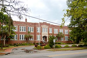
Many important places in Marion are listed on the National Register of Historic Places. These include the Marion High School, the Marion County Court House, the Marion County Library, the Marion County Museum, and the Marion Historic District.
Early Settlements
About 60 years after the first people settled in South Carolina, some English settlers arrived in Georgetown. They traveled up the Pee Dee River to a spot near where the Little Pee Dee River joins it. This was about halfway between Georgetown and the current city of Marion. Families like the Brittons, Davis, Flaglers, Giles, Graves, and Tyler were among these early settlers.
Around the same time, Captain John Godbold, a retired English sea captain, settled further up the Big Pee Dee River. He chose a spot on Catfish Creek, which is very close to what is now Marion.
Naming the City
In its early days, the area was part of a larger region called Craven County. Later, this land became part of the Georgetown District. For a while, it was known as Gilesboro, named after Colonel Hugh Giles. He was a hero who fought under General Francis Marion in the American Revolutionary War. For a short time in 1785, the area was even called "Liberty."
On December 17, 1847, the South Carolina Legislature officially named the town "Marion." This name was chosen to honor General Francis Marion, often called the "Swamp Fox," who was a great hero of the Revolutionary War.
The Court House and Wars
A special group was chosen to find a good spot for a court house. In March 1800, court was held in a log building on Colonel Hugh Giles's land. The area was known as Gilesboro Court House for some time. The group chose four acres of land from Thomas Godbold for the court house. The current court house was built in 1854. It is the third court house built on or near the same spot.
During the Revolutionary War, people in Marion County had different ideas about who to support. Some were strong Patriots, like Colonel Hugh Giles and Captain John Dozier. Others were Loyalists, who supported the British. However, General Francis Marion's actions in the area convinced most Loyalists to join the colonists. Some battles fought in the county during this war were Port's Ferry, Blue Savannah, and Bowling Green.
During the American Civil War, Marion County was lucky. General Sherman's troops could not cross the Big Pee Dee River because it was flooded. This saved the county from being damaged by the war. After the war, the county worked to rebuild. The mascot for Marion High School is the Swamp Fox, honoring General Francis Marion.
Railroad and Growth
Marion County grew a lot when the Wilmington to Manchester Railroad was completed in 1854. This made business and transportation much better. General W.W. Harllee was the first president of this railroad. The town of Florence was named after his daughter. Colonel William S. Mullins was the second president, and the town of Mullins was named after him.
County Changes
Over time, parts of Marion County were separated to form new counties. In 1888, a western part became Florence County. In 1910, the northern part became Dillon County.
Geography and Climate
Marion is located at 34°10′48″N 79°23′50″W / 34.18000°N 79.39722°W. The city covers about 4.3 square miles (11.1 square kilometers), and all of it is land.
Weather in Marion
| Climate data for Marion, South Carolina (1991–2020 normals, extremes 1893, 1898, 1927–1994, 2006–present) | |||||||||||||
|---|---|---|---|---|---|---|---|---|---|---|---|---|---|
| Month | Jan | Feb | Mar | Apr | May | Jun | Jul | Aug | Sep | Oct | Nov | Dec | Year |
| Record high °F (°C) | 84 (29) |
85 (29) |
93 (34) |
96 (36) |
101 (38) |
108 (42) |
108 (42) |
106 (41) |
102 (39) |
101 (38) |
88 (31) |
83 (28) |
108 (42) |
| Mean daily maximum °F (°C) | 56.1 (13.4) |
59.8 (15.4) |
66.9 (19.4) |
75.4 (24.1) |
82.1 (27.8) |
87.6 (30.9) |
90.5 (32.5) |
88.9 (31.6) |
84.2 (29.0) |
75.8 (24.3) |
66.1 (18.9) |
59.4 (15.2) |
74.4 (23.6) |
| Daily mean °F (°C) | 45.0 (7.2) |
48.1 (8.9) |
54.6 (12.6) |
62.3 (16.8) |
70.5 (21.4) |
77.5 (25.3) |
80.8 (27.1) |
79.3 (26.3) |
74.0 (23.3) |
63.7 (17.6) |
54.2 (12.3) |
48.0 (8.9) |
63.2 (17.3) |
| Mean daily minimum °F (°C) | 33.9 (1.1) |
36.5 (2.5) |
42.4 (5.8) |
49.3 (9.6) |
59.0 (15.0) |
67.4 (19.7) |
71.0 (21.7) |
69.6 (20.9) |
63.8 (17.7) |
51.6 (10.9) |
42.2 (5.7) |
36.6 (2.6) |
51.9 (11.1) |
| Record low °F (°C) | 0 (−18) |
11 (−12) |
10 (−12) |
24 (−4) |
31 (−1) |
42 (6) |
49 (9) |
46 (8) |
39 (4) |
22 (−6) |
15 (−9) |
0 (−18) |
0 (−18) |
| Average precipitation inches (mm) | 3.51 (89) |
3.22 (82) |
3.51 (89) |
3.43 (87) |
3.62 (92) |
4.96 (126) |
5.23 (133) |
5.54 (141) |
5.97 (152) |
3.26 (83) |
3.33 (85) |
3.69 (94) |
49.27 (1,251) |
| Source: NOAA | |||||||||||||
Population of Marion
| Historical population | |||
|---|---|---|---|
| Census | Pop. | %± | |
| 1850 | 214 | — | |
| 1870 | 968 | — | |
| 1880 | 824 | −14.9% | |
| 1890 | 1,640 | 99.0% | |
| 1900 | 1,831 | 11.6% | |
| 1910 | 3,844 | 109.9% | |
| 1920 | 3,892 | 1.2% | |
| 1930 | 4,921 | 26.4% | |
| 1940 | 5,746 | 16.8% | |
| 1950 | 6,834 | 18.9% | |
| 1960 | 7,174 | 5.0% | |
| 1970 | 7,435 | 3.6% | |
| 1980 | 7,700 | 3.6% | |
| 1990 | 7,658 | −0.5% | |
| 2000 | 7,042 | −8.0% | |
| 2010 | 6,939 | −1.5% | |
| 2020 | 6,448 | −7.1% | |
| U.S. Decennial Census | |||
People in Marion (2020 Census)
In 2020, there were 6,448 people living in Marion. These people lived in 2,345 households, which are like homes or families.
| Race | Num. | Perc. |
|---|---|---|
| White (non-Hispanic) | 1,592 | 24.69% |
| Black or African American (non-Hispanic) | 4,499 | 69.77% |
| Native American | 20 | 0.31% |
| Asian | 73 | 1.13% |
| Other/Mixed | 188 | 2.92% |
| Hispanic or Latino | 76 | 1.18% |
Education in Marion
The Marion County School District manages the public schools in the area. This school system also has an alternative school for middle and high school students. There is a vocational career center where students can learn job skills. An adult learning center helps grown-ups continue their education.
Pee Dee Academy is a private school in Marion. The city also has a technical center called the Academy for Careers and Technology. For those wanting to go to college, there are several nearby options. These include Francis Marion University, Florence–Darlington Technical College, Coker College, and Coastal Carolina University.
Marion also has a public library, which is part of the Marion County Library System.
Neighborhoods
Marion has several neighborhoods where people live. Some of these include:
- Fox Hollow
- Williams Park
- West Marion
- Rogers Park
- North Main Street
- South Main Street
- Highland
- East Marion
Notable People from Marion
Many interesting people have come from Marion, South Carolina. Here are a few:
- Levern Tart – An American basketball player.
- M. Warley Platzek – A lawyer and judge for the New York Supreme Court.
- Armstrong Williams – A well-known owner of broadcast TV stations in the United States.
Transportation
Getting around Marion and to other places is easy with several transportation options.
Airports
- Myrtle Beach International Airport (MYR) – This airport is about 43 miles southeast of Marion.
- Marion County Airport (MAO) – A local airport for smaller planes.
- Florence Regional Airport (FLO) – Another regional airport nearby.
Highways
Major highways that pass through or near Marion include:
 US 76
US 76 US 501
- SC 576
- SC 41
Industry
Marion is home to several businesses and industries. These companies provide jobs and help the local economy.
- Coca-Cola – Has a distribution plant in Marion.
- Marion Industrial Park – An area with many different businesses.
- Sunbelt Roofing Service Inc.
- Commercial Glass and Metal – A company that designs and makes architectural glass.
- Normont Motion Technology
See also
 In Spanish: Marion (Carolina del Sur) para niños
 | Calvin Brent |
 | Walter T. Bailey |
 | Martha Cassell Thompson |
 | Alberta Jeannette Cassell |


