Dillon County, South Carolina facts for kids
Quick facts for kids
Dillon County
|
|||
|---|---|---|---|

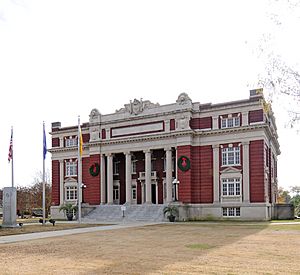
Dillon County Courthouse
|
|||
|
|||
| Nickname(s):
The Golden Land
|
|||

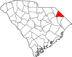
Location within the U.S. state of South Carolina
|
|||
 South Carolina's location within the U.S. |
|||
| Country | |||
| State | |||
| Founded | 1910 | ||
| Named for | James W. Dillon | ||
| Seat | Dillon | ||
| Largest community | Dillon | ||
| Area | |||
| • Total | 406.82 sq mi (1,053.7 km2) | ||
| • Land | 405.07 sq mi (1,049.1 km2) | ||
| • Water | 1.75 sq mi (4.5 km2) 0.43% | ||
| Population
(2020)
|
|||
| • Total | 28,292 | ||
| • Estimate
(2023)
|
27,698 | ||
| • Density | 69.84/sq mi (26.97/km2) | ||
| Time zone | UTC−5 (Eastern) | ||
| • Summer (DST) | UTC−4 (EDT) | ||
| Congressional district | 7th | ||
Dillon County is a county found in the northeastern part of South Carolina. It's a great place to learn about history and nature. In 2020, about 28,292 people lived here. The main town and county seat is Dillon.
Contents
History of Dillon County
Dillon County was created in 1910. It was formed from a part of Marion County. Both the county and the city of Dillon are named after a very important person. His name was James W. Dillon (1826–1913).
James W. Dillon was an Irishman who settled in the area. He worked hard to bring the railroad to the community. This effort led to the building of the Wilson Short Cut Railroad. This railroad later became part of the Atlantic Coast Line Railroad. The railroad helped Dillon County connect to other places. It also brought more growth and success to the area.
Geography of Dillon County
Dillon County covers about 407 square miles (1,054 square kilometers). Most of this area is land. Only a small part, about 1.75 square miles (4.5 square kilometers), is water. This makes Dillon County the fifth-smallest county in South Carolina.
Parks and Historic Sites
Dillon County has some special places to visit. These include parks and historic sites.
- Bass Community Park
- Dillon County Museum
- Little Pee Dee State Park
- Little Pee Dee State Park Bay Heritage Preserve
Rivers and Swamps
Many important water bodies flow through Dillon County.
- Cud Swamp
- Great Pee Dee River
- Little Pee Dee River
- Lumber River
- Maidendown Swamp
- Reedy Creek
Neighboring Counties
Dillon County shares its borders with several other counties. Some are in North Carolina, and some are in South Carolina.
- Robeson County, North Carolina – to the north
- Columbus County, North Carolina – to the north
- Horry County – to the east
- Marion County – to the south
- Florence County – to the southwest
- Marlboro County – to the west
Main Roads and Transportation
Many major highways run through Dillon County. These roads help people travel and transport goods.
 Future I-73
 I-95
I-95 US 301
 US 501
 SC 9
SC 9


 SC 9 Conn.
 SC 34
SC 34 SC 38
SC 38 SC 41
SC 41


 SC 41 Alt.
 SC 57
SC 57 SC 917
Dillon County also has important transportation hubs.
- Dillon County Airport
- Dillon Station (a train station)
- Inland Port Dillon (a big rail depot for shipping goods)
People of Dillon County (Demographics)
| Historical population | |||
|---|---|---|---|
| Census | Pop. | %± | |
| 1910 | 22,615 | — | |
| 1920 | 25,278 | 11.8% | |
| 1930 | 25,733 | 1.8% | |
| 1940 | 29,625 | 15.1% | |
| 1950 | 30,930 | 4.4% | |
| 1960 | 30,584 | −1.1% | |
| 1970 | 28,838 | −5.7% | |
| 1980 | 31,083 | 7.8% | |
| 1990 | 29,114 | −6.3% | |
| 2000 | 30,722 | 5.5% | |
| 2010 | 32,062 | 4.4% | |
| 2020 | 28,292 | −11.8% | |
| 2023 (est.) | 27,698 | −13.6% | |
| U.S. Decennial Census 1790–1960 1900–1990 1990–2000 2010 2020 |
|||
2020 Census Information
In 2020, the county had 28,292 people living in it. There were 11,029 households and 7,016 families.
The people living in Dillon County come from different backgrounds.
| Race | Num. | Perc. |
|---|---|---|
| White (not Hispanic) | 12,987 | 45.9% |
| Black or African American (not Hispanic) | 12,709 | 44.92% |
| Native American | 603 | 2.13% |
| Asian | 63 | 0.22% |
| Pacific Islander | 1 | 0.0% |
| Other/Mixed | 1,073 | 3.79% |
| Hispanic or Latino | 856 | 3.03% |
Life in Dillon County
In 2010, the average household had about 2.65 people. The average family had about 3.20 people. The median age of people in the county was 36.7 years old.
The average income for a household was about $26,818 per year. For families, it was about $34,693 per year. About 30.5% of the people in the county lived below the poverty line. This included many young people and seniors.
Economy of Dillon County
The economy of Dillon County is growing. In 2022, the total value of goods and services produced was about $887.9 million. This is called the GDP. The unemployment rate in the county has changed between 3.6% and 5.7% from 2022 to 2024.
Some of the biggest employers in Dillon County are:
- Food Lion (a grocery store)
- Harbor Freight Tools (a tool store)
- McLeod Health (a healthcare provider)
- Perdue Farms (a food company)
- Walmart (a large retail store)
These businesses provide many jobs for the people living in the county.
Fun Places to Visit (Attractions)
Dillon County has several interesting places to visit.
- Dillon County Museum (learn about local history)
- Dillon Motor Speedway (for racing fans)
- Little Pee Dee State Park (enjoy nature and outdoor activities)
- South of the Border (a famous roadside attraction)
Communities in Dillon County
Dillon County is made up of several cities, towns, and smaller communities.
Cities
- Dillon (This is the main town and the largest community.)
Towns
Census-designated places
These are areas that are like towns but are not officially incorporated as cities or towns.
- Floydale
- Hamer
- Little Rock
- Newtown
Other Communities
Many other smaller communities are located throughout Dillon County.
- Bass Crossroads
- Berrys Crossroads
- Bingham
- Bronson Crossroads
- Bunker Hill
- Carmichael Crossroads
- Carolina
- Carter Landing
- Centerville
- Cotton Valley
- Dalcho
- Dothan
- Dunbarton
- Five Forks
- Fork
- Forrest Hills
- Gaddys Crossroads
- Gaddys Mill
- Galavon
- Hayestown
- High Hill Crossroads
- Jacksonville
- Judson
- Kemper
- Kentyre
- Linkside
- Mallory
- Mallory Beach
- Manning Crossroads
- May Hilltop
- McCormick Crossroads
- Minturn
- Mount Calvary
- Newtown
- Oak Grove
- Oakland Crossroads
- Oliver Crossroads
- Pittman Corner
- Riverdale
- Selma
- Sinclair Crossroads
- South of the Border
- Squires
- Squires Curve
- Temperance Hill
See also
 In Spanish: Condado de Dillon para niños
 | DeHart Hubbard |
 | Wilma Rudolph |
 | Jesse Owens |
 | Jackie Joyner-Kersee |
 | Major Taylor |


