Dunbarton, South Carolina facts for kids
Dunbarton was a small town in Barnwell County, South Carolina, USA. People first settled here around the year 1800. The town grew bigger when a train stop was built on a new railway line. However, in 1951, the United States government bought the land. It became part of a large area called the Savannah River Site. This site was built for important national defense work. The closest town to where Dunbarton used to be is Snelling.
Contents
The Story of Dunbarton
How Dunbarton Started
The town of Dunbarton began to grow around 1899. This was when the Atlantic Coast Line Railroad built a new train track. This track connected Denmark, South Carolina, to a place called Robins. Robins was also on another important railway line.
The town of Dunbarton officially became a town in 1910. It was named after the Dunbar family. Dunbarton was a busy place. It was known for farming, trading goods, and sawmills.
By the early 1950s, about 300 people lived in Dunbarton. The town had around 35 homes and 15 shops. There was one church and two schools, including Dunbarton High School. There were also two cotton gins and a train station. Four Mile High School, a school for African-American students, was just outside town. It had dorms for students who lived far away.
Why the Town Disappeared
On November 28, 1950, a big announcement was made. The U.S. Atomic Energy Commission and the DuPont Company shared their plans. They would build the Savannah River Plant in South Carolina. This huge site would cover about 300 square miles. It would be in Aiken, Barnwell, and Allendale counties.
The Savannah River Plant was built to make special materials. These materials, like plutonium and tritium, were needed for national defense. To build this plant, the government needed a lot of land.
About 6,000 people had to move from their homes. This included everyone living in Dunbarton and another town called Ellenton. Several smaller communities also had to move. Many of those who moved were farmers.
The government bought the land or took it for public use. Many residents moved their families and even their houses. They went to nearby towns like Barnwell, Williston, and Aiken. Some people moved to other states. Eventually, almost everything in Dunbarton was gone. Only the streets, sidewalks, and driveways remained.
Where Dunbarton Was Located
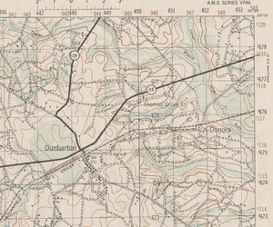
Dunbarton was located at about 33°12'40" North and 81°33' West. It was found where South Carolina highways 39 and 64 crossed. The railroad also ran through this spot. Today, parts of these old highways are known as SRS "B" and SRS "F" within the Savannah River Site.
Remembering Dunbarton
Even though the town is gone, the spirit of Dunbarton lives on. Former residents and their families have an annual reunion. This tradition started in 1952 and continues to this day. It helps them remember their old home and stay connected.
 | Bayard Rustin |
 | Jeannette Carter |
 | Jeremiah A. Brown |


