
Allendale County, South Carolina facts for kids
Quick facts for kids
Allendale County
|
||
|---|---|---|

Allendale County Courthouse
|
||
|
||

Location within the U.S. state of South Carolina
|
||
 South Carolina's location within the U.S. |
||
| Country | ||
| State | ||
| Founded | 1919 | |
| Named for | Paul H. Allen | |
| Seat | Allendale | |
| Largest community | Allendale | |
| Area | ||
| • Total | 412.42 sq mi (1,068.2 km2) | |
| • Land | 408.10 sq mi (1,057.0 km2) | |
| • Water | 4.32 sq mi (11.2 km2) 1.05% | |
| Population
(2020)
|
||
| • Total | 8,039 | |
| • Estimate
(2023)
|
7,369 | |
| • Density | 19.70/sq mi (7.61/km2) | |
| Time zone | UTC−5 (Eastern) | |
| • Summer (DST) | UTC−4 (EDT) | |
| Congressional district | 6th | |

Allendale County is a county in South Carolina, a state in the United States. It was created in 1919. In 2020, about 8,039 people lived there. This makes it the county with the smallest population in South Carolina. The main town and county seat is Allendale.
Contents
History of Allendale County
Allendale County was formed in 1919. It was made from parts of Barnwell County and Hampton County. People wanted a new county so they wouldn't have to travel far to the courthouse.
One very old and important place in Allendale County is the Topper Site. This is an archaeological dig site. Scientists have found tools and other things there that might be 50,000 years old! This would mean people lived there long before the well-known Clovis culture. The site is near a special type of rock called chert. Archeologists from the University of South Carolina have been studying the Topper Site since 1999.
The original Allendale County Courthouse burned down in 1998. It was rebuilt a few years later. During the Civil Rights Movement, people in the county worked for fair voting rights. African-American citizens wanted to make sure everyone could register to vote without delays.
Geography of Allendale County
Allendale County covers about 412 square miles. Most of this is land, with a small part being water. The Savannah River forms the western border of the county, separating it from Georgia.
Allendale is not far from several major cities. It is about 62 miles from Augusta, Georgia, and 73 miles from Savannah, Georgia. It is also about 87 miles from Columbia, the capital of South Carolina. Before big highways were built, many travelers used to stop in Allendale.
Rivers and Waterways
- Coosawhatchie River
- Salkehatchie River
- Savannah River
Neighboring Counties
Allendale County shares borders with several other counties:
- Bamberg County (to the northeast)
- Colleton County (to the east)
- Hampton County (to the southeast)
- Screven County, Georgia (to the southwest)
- Burke County, Georgia (to the west)
- Barnwell County (to the northwest)
Main Roads
Several important highways pass through Allendale County:
 US 278
 US 301
 US 321
 SC 3
SC 3 SC 47
SC 47 SC 125
 SC 300
 SC 641
Other Important Sites
- Savannah River Site (a part of this large federal site is in Allendale County)
People of Allendale County (Demographics)
| Historical population | |||
|---|---|---|---|
| Census | Pop. | %± | |
| 1920 | 16,098 | — | |
| 1930 | 13,294 | −17.4% | |
| 1940 | 13,040 | −1.9% | |
| 1950 | 11,773 | −9.7% | |
| 1960 | 11,362 | −3.5% | |
| 1970 | 9,692 | −14.7% | |
| 1980 | 10,700 | 10.4% | |
| 1990 | 11,722 | 9.6% | |
| 2000 | 11,211 | −4.4% | |
| 2010 | 10,419 | −7.1% | |
| 2020 | 8,039 | −22.8% | |
| 2023 (est.) | 7,369 | −29.3% | |
| U.S. Decennial Census 1790–1960 1900–1990 1990–2000 2010 2020 |
|||
Every ten years, the U.S. government counts how many people live in each area. This is called a census.
2020 Census Information
In 2020, the census showed that 8,039 people lived in Allendale County. There were 3,281 households, which are groups of people living together. About 23.7% of these households had children. Many homes in the county are rented (35.6%). The county has more housing available than households. The average household size was 2 people.
Most people in Allendale County are Black or African American (70.23%). White people make up 24.69% of the population. Other groups, like Native American, Asian, and people of mixed races, also live there. About 2.41% of the population is of Hispanic or Latino origin.

2010 Census Information
In 2010, there were 10,419 people living in the county. The population density was about 25.5 people per square mile. Most people were Black or African American (73.6%). White people made up 23.7% of the population. The median age was 38.8 years.
The median household income was $20,081. This means half of the households earned more than this, and half earned less. About 42.4% of the population lived below the poverty line.
Economy of Allendale County
Allendale County is mostly a rural area with a focus on farming. The main crops grown here are cotton, soybeans, watermelon, and cantaloupe. Timbering, which is cutting down trees for wood, is also important. The wood is often used to make paper pulp.
In 2022, the total value of all goods and services produced in Allendale County was about $317.5 million. This is called the GDP. The unemployment rate in the county has changed over the years, usually staying between 4% and 8%.
Some of the largest employers in Allendale County include:
- Atlantic Power Corporation
- AZ Electronic Materials
- Georgia-Pacific
- South Carolina Department of Corrections (SCDC)
- The University of South Carolina (through its local campus)
Education in Allendale County
Colleges and Universities
- USC-Salkahatchie: This is a two-year college campus. It is located in the town of Allendale.
- Denmark Tech: This college is part of the state's technical college system. It serves Allendale County from its location in Bamberg County, about 25 miles away.
Allendale County also has WEBA, Channel 14. This is a TV station that is part of the South Carolina Educational Television Network. Even though Allendale is one of the smallest counties in the state, it has both a state-supported college and an educational TV station.
K-12 Schools
Allendale County has one school district called the Allendale County School District. This district includes Allendale-Fairfax High School. In the past, there were separate schools for African-American students, like the former C. V. Bing High School, before schools became desegregated.
Media in Allendale County
Allendale County is considered a "news desert." This means there are no longer any local newspapers. The last local papers, The Citizen-Leader and The Allendale Sun, stopped printing in 2014 and 2015.
Communities in Allendale County
Towns
Unincorporated Communities
These are smaller communities that are not officially organized as towns.
- Appleton
- Martin
Images for kids
-

Seal of Allendale County
-
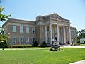
The Allendale County Courthouse
See also
 In Spanish: Condado de Allendale para niños
