
Hampton County, South Carolina facts for kids
Quick facts for kids
Hampton County
|
||
|---|---|---|

Hampton County Courthouse
|
||
|
||
| Motto(s): | ||

Location within the U.S. state of South Carolina
|
||
 South Carolina's location within the U.S. |
||
| Country | ||
| State | ||
| Founded | 1878 | |
| Named for | Wade Hampton III | |
| Seat | Hampton | |
| Largest community | Hampton | |
| Area | ||
| • Total | 562.71 sq mi (1,457.4 km2) | |
| • Land | 559.98 sq mi (1,450.3 km2) | |
| • Water | 2.73 sq mi (7.1 km2) 0.49% | |
| Population
(2020)
|
||
| • Total | 18,561 | |
| • Estimate
(2023)
|
18,122 | |
| • Density | 33.15/sq mi (12.80/km2) | |
| Time zone | UTC−5 (Eastern) | |
| • Summer (DST) | UTC−4 (EDT) | |
| Congressional district | 6th | |

Hampton County is a rural area in the state of South Carolina, United States. It is home to about 18,561 people, based on the 2020 census. The main town and government center is Hampton. The county is named after Wade Hampton III. He was a general during the American Civil War and later became the governor of South Carolina.
Contents
History
Hampton County gets its name from Wade Hampton III. He was a very important person in South Carolina's history. He was a Lieutenant General for the Confederacy during the American Civil War. After the war, he worked to bring back Democratic rule in South Carolina. He led groups like the Redeemers and Red Shirts. These groups aimed to change things back to how they were before the war. After the Reconstruction era ended, he became the Governor of South Carolina. Later, he served as a U.S. Senator.
The county's population was highest around 1910. At that time, farming was the main way people made a living. Many African Americans later moved away from the county. They went to cities, especially in the North, during the Great Migration. This happened because farming became more mechanized. This meant fewer jobs were available on farms.
Geography
Hampton County covers a total area of about 562.71 square miles. Most of this area, about 559.98 square miles, is land. Only a small part, about 2.73 square miles, is water.
Protected Natural Areas
Hampton County has several important natural areas. These places help protect wildlife and nature.
National Protected Area
- Ernest F. Hollings ACE Basin National Wildlife Refuge (part of it is in Hampton County)
State and Local Protected Areas
- Hamilton Ridge Wildlife Management Area
- James W Webb Wildlife Center and Game Management Area
- Lake Warren State Park
- Palachucola Wildlife Management Area
- Webb Wildlife Center
Rivers and Lakes
Several important rivers and a lake are found in Hampton County:
- Coosawhatchie River
- Lake George Warren
- Little Salkehatchie River
- Salkehatchie River
- Savannah River
Neighboring Counties
Hampton County shares borders with several other counties:
- Bamberg County – to the north
- Colleton County – to the east
- Beaufort County – to the southeast
- Jasper County – to the south
- Effingham County, Georgia – to the southwest
- Screven County, Georgia – to the west
- Allendale County – to the northwest
Main Roads
Many important highways pass through Hampton County:
 I-95
I-95 US 21
US 21
 US 17 Alt.
 US 278
 US 321
 US 601
 SC 3
SC 3 SC 63
SC 63 SC 68
SC 68 SC 333
 SC 363
Key Transportation Hubs
- Yemassee Station
People of Hampton County (Demographics)
| Historical population | |||
|---|---|---|---|
| Census | Pop. | %± | |
| 1880 | 18,741 | — | |
| 1890 | 20,544 | 9.6% | |
| 1900 | 23,738 | 15.5% | |
| 1910 | 25,126 | 5.8% | |
| 1920 | 19,550 | −22.2% | |
| 1930 | 17,243 | −11.8% | |
| 1940 | 17,465 | 1.3% | |
| 1950 | 18,027 | 3.2% | |
| 1960 | 17,425 | −3.3% | |
| 1970 | 15,878 | −8.9% | |
| 1980 | 18,159 | 14.4% | |
| 1990 | 18,191 | 0.2% | |
| 2000 | 21,386 | 17.6% | |
| 2010 | 21,090 | −1.4% | |
| 2020 | 18,561 | −12.0% | |
| 2023 (est.) | 18,122 | −14.1% | |
| U.S. Decennial Census 1790–1960 1900–1990 1990–2000 2010 2020 |
|||
The population of Hampton County has changed over the years. It reached its highest point in 1910. By 2020, the population was 18,561 people.
Population in 2020
| Race | Num. | Perc. |
|---|---|---|
| White (non-Hispanic) | 7,802 | 42.03% |
| Black or African American (non-Hispanic) | 9,536 | 51.38% |
| Native American | 41 | 0.22% |
| Asian | 100 | 0.54% |
| Pacific Islander | 17 | 0.09% |
| Other/Mixed | 399 | 2.15% |
| Hispanic or Latino | 666 | 3.59% |
In 2020, there were 18,561 people living in Hampton County. These people lived in 6,993 households. About 4,148 of these households were families.
Population in 2010
In 2010, Hampton County had 21,090 people. The population density was about 37.7 people per square mile. Most people were Black or African American (53.9%). White people made up 42.7% of the population. Other groups included Asian, American Indian, and people of mixed races. About 3.5% of the population was Hispanic or Latino.
There were 7,598 households in 2010. About 35.8% of these households had children under 18. The average household had 2.57 people. The average family had 3.15 people. The average age of people in the county was 38.4 years.
Economy
The economy of Hampton County involves different types of jobs and businesses. In 2022, the total value of all goods and services produced in the county was about $542.4 million. This is called the GDP. The unemployment rate, which is the percentage of people looking for jobs who don't have one, was low. It was around 2.8-2.9% in 2022 and 2023.
Some of the biggest employers in Hampton County are:
- The United States Department of Justice
- Food Lion (a grocery store)
- The Habit Burger Grill (a restaurant)
- Hampton Regional Medical Center (a hospital)
- Le Creuset (a company that makes kitchenware)
Towns and Communities
Hampton County has several towns and smaller communities where people live.
Towns
Unincorporated Communities
These are smaller communities that are not officially towns:
- Crocketville
- Lena
- McPhersonville
- Nixville
Images for kids
-
The official seal of Hampton County.
-
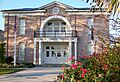
The Hampton County Courthouse building.
See also
 In Spanish: Condado de Hampton para niños
