Colleton County, South Carolina facts for kids
Quick facts for kids
Colleton County
|
||
|---|---|---|

|
||
|
||

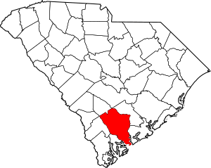
Location within the U.S. state of South Carolina
|
||
 South Carolina's location within the U.S. |
||
| Country | ||
| State | ||
| Founded | 1800 | |
| Named for | Sir John Colleton, 1st Baronet | |
| Seat | Walterboro | |
| Largest community | Walterboro | |
| Area | ||
| • Total | 1,133.28 sq mi (2,935.2 km2) | |
| • Land | 1,056.50 sq mi (2,736.3 km2) | |
| • Water | 76.78 sq mi (198.9 km2) 6.78% | |
| Population
(2020)
|
||
| • Total | 38,604 | |
| • Estimate
(2023)
|
38,874 | |
| • Density | 36.54/sq mi (14.11/km2) | |
| Time zone | UTC−5 (Eastern) | |
| • Summer (DST) | UTC−4 (EDT) | |
| Congressional districts | 1st, 6th | |
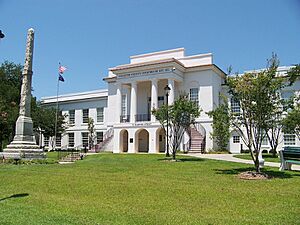
Colleton County is a county in the Lowcountry area of South Carolina, a state in the United States. In 2020, about 38,604 people lived there. The main town and county seat is Walterboro.
The county is named after Sir John Colleton, 1st Baronet. He was one of the eight Lords Proprietor who owned the land of the Province of Carolina a long time ago. Colleton County was officially created in 1800, after a couple of earlier versions.
Contents
History of Colleton County
In 1682, Colleton was one of the first three counties made in the new South Carolina Colony. It was located in the southwestern part of the coast, near the Combahee River.
Around 1706, the county was split into two new areas called Saint Bartholomew and Saint Paul parishes. This region became known for large farms that grew crops like rice and indigo. These farms relied on the work of many people, including enslaved Africans who were brought to Charleston. By 1708, there were more enslaved people than white colonists in the coastal areas.
Later, in 1734, a part of Saint Paul's Parish became Saint John's Colleton Parish. By 1769, these areas became part of the Charleston Judicial District.
In 1800, the western half of the Charleston District was used to create the new Colleton District. In 1816, a small piece of the Charleston District was added to it.
After the American Civil War, in 1868, South Carolina changed its districts into counties. This change meant that local people could vote for their leaders, making the government more democratic.
Over the years, parts of Colleton County were used to create new counties or were added to existing ones. For example, in 1897, Dorchester County was formed from the northeastern part of Colleton County.
In 1911, the part of the county east of the Edisto River was added to Charleston County. Small parts were also added to Bamberg County in 1919 and 1920.
Finally, in March 1975, the town of Edisto Beach became part of Colleton County. This brought the county to its current size.
Geography of Colleton County
Colleton County covers a total area of about 1,133 square miles (2,935 square kilometers). About 1,056 square miles (2,735 square kilometers) is land, and 76 square miles (197 square kilometers) is water. It is one of the largest counties in South Carolina by land area.
Protected Natural Areas
Colleton County is home to several important natural areas that are protected. These include:
- Ashepoo-Combahee-Edisto (ACE) Basin National Estuarine Research Reserve (part)
- Ernest F. Hollings ACE Basin National Wildlife Refuge (part)
State and Local Sites
You can also find these interesting places in the county:
- Bear Island Wildlife Management Area
- Colleton State Park
- Crosby Oxypolis Heritage Preserve
- Donnelley Wildlife Management Area
- Givhans Ferry State Park (part)
- Lowcountry Raptors
- Old Walterboro Train Depot
- Pon-Pon Chapel of Ease
- South Fenwick Island
- St. Helena Sound Heritage Preserve/Wildlife Management Area
- Tuskegee Airmen Memorial
- Walterboro Historic District
Major Rivers and Ocean
Important water bodies in Colleton County include:
- Ashepoo River
- Atlantic Ocean (North Atlantic Ocean)
- Edisto River
- Intracoastal Waterway
- Salkehatchie River
Neighboring Counties
Colleton County shares its borders with these counties:
- Orangeburg County – to the north
- Dorchester County – to the northeast
- Charleston County – to the east
- Beaufort County – to the south
- Hampton County – to the west
- Allendale County – to the west
- Bamberg County – to the northwest
Main Roads
Several major highways pass through Colleton County, connecting it to other parts of the state and country:
 I-95
I-95 US 15
US 15 US 17
US 17
 US 17 Alt.
 US 21
US 21 US 601
 SC 61
SC 61 SC 63
SC 63 SC 64
SC 64


 SC 64 Bus.
 SC 174
 SC 212


 SC 212 Conn.
 SC 217
 SC 303
 SC 362
 SC 641
 SC 651
Important Facilities
- Lowcountry Regional Airport
People in Colleton County
| Historical population | |||
|---|---|---|---|
| Census | Pop. | %± | |
| 1800 | 24,903 | — | |
| 1810 | 26,359 | 5.8% | |
| 1820 | 26,404 | 0.2% | |
| 1830 | 27,256 | 3.2% | |
| 1840 | 25,548 | −6.3% | |
| 1850 | 39,505 | 54.6% | |
| 1860 | 41,916 | 6.1% | |
| 1870 | 25,410 | −39.4% | |
| 1880 | 38,386 | 51.1% | |
| 1890 | 40,293 | 5.0% | |
| 1900 | 33,452 | −17.0% | |
| 1910 | 35,390 | 5.8% | |
| 1920 | 29,897 | −15.5% | |
| 1930 | 25,821 | −13.6% | |
| 1940 | 26,268 | 1.7% | |
| 1950 | 28,242 | 7.5% | |
| 1960 | 27,816 | −1.5% | |
| 1970 | 27,622 | −0.7% | |
| 1980 | 31,776 | 15.0% | |
| 1990 | 34,377 | 8.2% | |
| 2000 | 38,264 | 11.3% | |
| 2010 | 38,892 | 1.6% | |
| 2020 | 38,604 | −0.7% | |
| 2023 (est.) | 38,874 | 0.0% | |
| U.S. Decennial Census 1790–1960 1900–1990 1990–2000 2010 2020 |
|||
2020 Census Information
In 2020, the census showed that 38,604 people lived in Colleton County. There were about 15,075 households, which are groups of people living together.
Here's a look at the different groups of people living in Colleton County in 2020:
| Race | Number of People | Percentage |
|---|---|---|
| White (not Hispanic) | 21,816 | 56.51% |
| Black or African American (not Hispanic) | 13,401 | 34.71% |
| Native American | 302 | 0.78% |
| Asian | 186 | 0.48% |
| Pacific Islander | 16 | 0.04% |
| Other/Mixed | 1,503 | 3.89% |
| Hispanic or Latino | 1,380 | 3.57% |
2010 Census Information
According to the 2010 census, there were 38,892 people living in the county. About 57% of the people were white, and 39% were black or African American. People of Hispanic or Latino background made up about 2.8% of the population.
The average age of people in Colleton County was about 40.7 years old.
Ancestry and Backgrounds
In 2019, the largest groups of people based on their family history were:
| Ancestry/ethnicity | Percent (2019) |
|---|---|
| African-American |
39.0% |
| English |
32.3% |
| German |
6.5% |
| Irish |
5.2% |
Economy in Colleton County
In 2022, the total value of all goods and services produced in Colleton County was about $1.1 billion. This is known as the Gross Domestic Product (GDP).
The number of people looking for jobs but not finding them (the unemployment rate) has been between 2.6% and 4.3% from 2022 to 2024.
Some of the biggest employers in Colleton County include the Colleton County School District, Cracker Barrel, Food Lion, and Walmart. These businesses provide many jobs for the people living in the county.
Education in Colleton County
Public Schools
- The Colleton County School District runs the public schools in the area.
- This includes Colleton County High School.
Higher Education
- If you want to go to college, you can earn degrees at the University of South Carolina Salkehatchie in Walterboro.
Communities in Colleton County
Colleton County has several towns and communities where people live.
Cities
- Walterboro (This is the county seat and the largest community.)
Towns
Census-Designated Places
These are areas that are like towns but are not officially incorporated as one:
Unincorporated Communities
These are smaller communities that are not part of any official city or town:
- Ashepoo
- Green Pond
- Hendersonville
- Neyles
- Round O
- Ruffin
- Canadys
See also
 In Spanish: Condado de Colleton para niños
 | John T. Biggers |
 | Thomas Blackshear |
 | Mark Bradford |
 | Beverly Buchanan |


