
Walterboro, South Carolina facts for kids
Quick facts for kids
Walterboro, South Carolina
|
||
|---|---|---|

East Washington Street in downtown Walterboro
|
||
|
||
| Motto(s):
The Front Porch of the Lowcountry
|
||

Location of Walterboro, South Carolina
|
||
| Country | United States | |
| State | South Carolina | |
| County | Colleton | |
| Area | ||
| • Total | 6.84 sq mi (17.72 km2) | |
| • Land | 6.84 sq mi (17.72 km2) | |
| • Water | 0.00 sq mi (0.00 km2) | |
| Elevation | 59 ft (18 m) | |
| Population
(2020)
|
||
| • Total | 5,544 | |
| • Density | 810.05/sq mi (312.78/km2) | |
| Time zone | UTC−5 (Eastern (EST)) | |
| • Summer (DST) | UTC−4 (EDT) | |
| ZIP code |
29488
|
|
| Area code(s) | 843, 854 | |
| FIPS code | 45-74275 | |
| GNIS feature ID | 1251318 | |

Walterboro is a city in Colleton County, South Carolina, United States. It is the main city of Colleton County. In 2020, about 5,544 people lived there. Walterboro is about 48 miles west of Charleston. It is also close to the ACE Basin area in the South Carolina Lowcountry.
Contents
History of Walterboro
How Walterboro Started
Walterboro was founded in 1783. It began as a summer getaway for local plantation owners. They wanted to escape the hot, wet areas of the Lowcountry where diseases like malaria were common. The first settlement was on a hilly spot with many pine and hickory trees. It was called Hickory Valley.
Two brothers, Paul and Jacob Walter, were among the first settlers. They owned large plantations nearby. Paul's young daughter, Mary, got sick with malaria. To help her, the brothers looked for a healthier place to live in the summer. They settled this new town, and it was later named in their honor.
Becoming the County Seat
In 1817, Walterboro became the third county seat of Colleton County. This means it became the main city for the county's government. A county courthouse and a county jail were built in 1821. A famous architect named Robert Mills designed the courthouse.
The town grew quickly after becoming the county seat. Its population also increased when a railroad line was built in the 1880s. This railroad connected Walterboro to Columbia and Charleston.
A Special Community: Catholic Hill
In 1832, an Irish Catholic community started a church in rural Walterboro. It was called St. James the Greater Catholic Church. This area later became known as Catholic Hill. After the church burned down in 1856, and slavery ended, many white families left. However, the Black Catholic community kept their faith strong for decades without a priest. A new church was built for them in the 1890s. This community became well-known, and a documentary about them was made in 2020.
Walterboro During World War II
An airfield was built in the 1930s. In 1942, Walterboro became home to the Walterboro Army Airfield. This was a big training base during World War II. It helped train fighter and bomber pilots for air combat. The base also had the largest camouflage school in the U.S. and a camp for 250 prisoners of war.
From 1944 to 1945, the airfield became a special training base for individual fighter pilots. Many of these were black trainees from Tuskegee Army Airfield in Tuskegee, Alabama. Over 500 of the famous Tuskegee Airmen trained here. This included pilots for the 332nd Fighter-Interceptor Squadron and the entire 447th Bombardment Group. The base closed in October 1945 and went back to being a local airfield.
Walterboro Today
In the 1960s, Interstate 95 was built. This highway made Walterboro a popular stop for travelers going to Florida or New York. Today, Walterboro has many historic homes from the 1820s. Its downtown area still has many old buildings. The city is now known as a great place for antiquing. It's a popular day trip from Charleston and Beaufort.
Geography and Climate
Where is Walterboro?
Walterboro is located slightly north of the center of Colleton County. You can find it at coordinates 32.904289 degrees North and -80.666238 degrees West. Interstate 95 runs west of the city. It goes northeast 110 miles to Florence and southwest 67 miles to Savannah, Georgia.
The end of U.S. Route 15 is in the center of Walterboro. This road goes north, parallel to I-95, reaching St. George in 21 miles. U.S. Route 17 Alt goes east from US 15, 32 miles to Summerville, near Charleston. It also goes southwest 21 miles to Yemassee. South Carolina Highway 64 goes northwest past I-95, 25 miles to Ehrhardt. It also goes southeast 16 miles to Jacksonboro.
The United States Census Bureau says Walterboro has a total area of about 6.84 square miles (17.72 square kilometers). All of this area is land.
Walterboro's Weather
Walterboro has a warm climate. Summers are hot and humid, while winters are mild. The highest temperature ever recorded was 107°F (42°C) in August. The lowest was 0°F (-18°C) in January. The city gets a good amount of rain throughout the year, especially in summer.
| Climate data for Walterboro, South Carolina (1991–2020 normals, extremes 1903–1920 and 1936–present) | |||||||||||||
|---|---|---|---|---|---|---|---|---|---|---|---|---|---|
| Month | Jan | Feb | Mar | Apr | May | Jun | Jul | Aug | Sep | Oct | Nov | Dec | Year |
| Record high °F (°C) | 85 (29) |
88 (31) |
98 (37) |
95 (35) |
103 (39) |
106 (41) |
106 (41) |
107 (42) |
105 (41) |
100 (38) |
91 (33) |
85 (29) |
107 (42) |
| Mean maximum °F (°C) | 75.3 (24.1) |
78.0 (25.6) |
83.9 (28.8) |
87.6 (30.9) |
93.0 (33.9) |
96.7 (35.9) |
98.2 (36.8) |
97.0 (36.1) |
93.2 (34.0) |
87.5 (30.8) |
81.8 (27.7) |
76.7 (24.8) |
99.3 (37.4) |
| Mean daily maximum °F (°C) | 58.1 (14.5) |
62.0 (16.7) |
68.7 (20.4) |
76.1 (24.5) |
82.8 (28.2) |
87.4 (30.8) |
90.5 (32.5) |
88.9 (31.6) |
84.2 (29.0) |
76.4 (24.7) |
67.7 (19.8) |
61.1 (16.2) |
75.3 (24.1) |
| Daily mean °F (°C) | 46.7 (8.2) |
49.8 (9.9) |
56.5 (13.6) |
63.3 (17.4) |
71.2 (21.8) |
77.5 (25.3) |
80.8 (27.1) |
79.5 (26.4) |
74.6 (23.7) |
64.7 (18.2) |
55.0 (12.8) |
49.5 (9.7) |
64.1 (17.8) |
| Mean daily minimum °F (°C) | 35.2 (1.8) |
37.6 (3.1) |
44.2 (6.8) |
50.4 (10.2) |
59.6 (15.3) |
67.6 (19.8) |
71.1 (21.7) |
70.1 (21.2) |
65.0 (18.3) |
53.1 (11.7) |
42.3 (5.7) |
37.9 (3.3) |
52.8 (11.6) |
| Mean minimum °F (°C) | 20.8 (−6.2) |
24.3 (−4.3) |
28.5 (−1.9) |
35.9 (2.2) |
46.6 (8.1) |
59.2 (15.1) |
64.9 (18.3) |
64.2 (17.9) |
54.0 (12.2) |
38.2 (3.4) |
28.3 (−2.1) |
24.5 (−4.2) |
19.2 (−7.1) |
| Record low °F (°C) | 0 (−18) |
9 (−13) |
15 (−9) |
26 (−3) |
31 (−1) |
44 (7) |
54 (12) |
55 (13) |
37 (3) |
24 (−4) |
11 (−12) |
5 (−15) |
0 (−18) |
| Average precipitation inches (mm) | 4.01 (102) |
3.74 (95) |
3.50 (89) |
3.56 (90) |
3.59 (91) |
5.63 (143) |
5.21 (132) |
7.17 (182) |
4.60 (117) |
3.68 (93) |
3.08 (78) |
3.65 (93) |
51.42 (1,306) |
| Average precipitation days | 8.4 | 7.9 | 8.0 | 6.9 | 7.0 | 10.1 | 10.5 | 11.8 | 8.1 | 6.1 | 6.2 | 7.9 | 98.9 |
| Source: NOAA | |||||||||||||
People of Walterboro
Population Changes Over Time
The population of Walterboro has changed over many years. Here's how it has grown and shrunk since 1870:
| Historical population | |||
|---|---|---|---|
| Census | Pop. | %± | |
| 1870 | 636 | — | |
| 1880 | 691 | 8.6% | |
| 1890 | 1,171 | 69.5% | |
| 1900 | 1,491 | 27.3% | |
| 1910 | 1,677 | 12.5% | |
| 1920 | 1,853 | 10.5% | |
| 1930 | 2,592 | 39.9% | |
| 1940 | 3,373 | 30.1% | |
| 1950 | 4,616 | 36.9% | |
| 1960 | 5,417 | 17.4% | |
| 1970 | 6,257 | 15.5% | |
| 1980 | 6,209 | −0.8% | |
| 1990 | 5,492 | −11.5% | |
| 2000 | 5,153 | −6.2% | |
| 2010 | 5,398 | 4.8% | |
| 2020 | 5,544 | 2.7% | |
| U.S. Decennial Census | |||
Who Lives in Walterboro? (2020 Census)
In 2020, there were 5,544 people living in Walterboro. There were 2,569 households and 1,265 families. The people living in Walterboro come from different backgrounds:
| Race | Num. | Perc. |
|---|---|---|
| White (non-Hispanic) | 2,354 | 42.46% |
| Black or African American (non-Hispanic) | 2,664 | 48.05% |
| Native American | 16 | 0.29% |
| Asian | 97 | 1.75% |
| Pacific Islander | 1 | 0.02% |
| Other/Mixed | 201 | 3.63% |
| Hispanic or Latino | 211 | 3.81% |
More About the People (2010 Census)
In 2010, there were 5,401 people in the city. About 44.1% were White, and 50.5% were African American. Other groups included Native American, Asian, and people of two or more races. About 2.9% of the population was Hispanic or Latino.
There were 2,231 households. About 28.2% of these had children under 18. The average household had 2.32 people. The average family had 2.90 people.
The population was spread out by age. About 25.8% were under 18 years old. About 17.9% were 65 years or older. The average age was 39 years.
Education in Walterboro
Walterboro is part of the Colleton County School District. The city has several schools:
- Public Elementary Schools: Bells Elementary, Cottageville Elementary, Hendersonville Elementary, Forest Hills Elementary, and Northside Elementary.
- Public Middle School: Colleton County Middle School.
- Public High School: Colleton County High School.
- Private K-12 Schools: Colleton Preparatory Academy and North Walterboro Christian Academy.
For higher education, University of South Carolina Salkehatchie is the local university. Clemson University also has an office in the city. Walterboro has a public library branch that is part of the Colleton County Library System.
Transportation and Travel
Walterboro is easy to reach from Interstate 95. Travelers often stop here because of the hotels, restaurants, and gas stations at exits 53 and 57. Other important roads include U.S. Highway 15 and Alternate U.S. Highway 17. The Lowcountry Regional Airport serves Walterboro and Colleton County for general aviation.
Notable People from Walterboro
Many interesting people have come from Walterboro, including:
- William Jones Boone, a bishop
- Bonnie Lynn Fields, an actress
- Nick Grant, a rapper
- Norman Hand, an American football player
- Brother Stair, a minister
- Craig Mack, a rapper
- Peden McLeod, an attorney and politician
- Dean Meminger, a basketball player and coach
- John Peurifoy, a diplomat
- Mary Shaffer, an artist
- Young Scooter, a rapper
- Marvin Herman Shoob, a judge
- Darwin Walker, an American football player
- Bill Workman, a politician
Images for kids
-
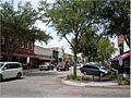
East Washington Street in downtown Walterboro
-
Seal of Walterboro, South Carolina
-
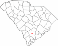
Location of Walterboro, South Carolina
See also
 In Spanish: Walterboro (Carolina del Sur) para niños
