
Summerville, South Carolina facts for kids
Quick facts for kids
Summerville
|
||
|---|---|---|

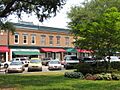
Downtown Summerville
|
||
|
||
| Nickname(s):
Flowertown
|
||
| Motto(s): | ||

Summerville
Location in South Carolina

Summerville
Location in the United States
|
||
| Country | ||
| State | ||
| Counties | Dorchester, Berkeley, Charleston | |
| Incorporated | December 17, 1847 | |
| Named for | New Summerville | |
| Government | ||
| • Type | Council–manager | |
| • Body | Summerville Town Council | |
| Area | ||
| • Total | 22.67 sq mi (58.72 km2) | |
| • Land | 22.54 sq mi (58.37 km2) | |
| • Water | 0.14 sq mi (0.35 km2) 5.24% | |
| Elevation | 89 ft (27 m) | |
| Population
(2020)
|
||
| • Total | 50,915 | |
| • Estimate
(2023)
|
51,884 | |
| • Density | 2,259.27/sq mi (872.30/km2) | |
| Time zone | UTC−5 (Eastern (EST)) | |
| • Summer (DST) | UTC−4 (EDT) | |
| ZIP codes |
29483-29486
|
|
| Area code(s) | 843, 854 | |
| FIPS code | 45-70270 | |
| GNIS feature ID | 1251073 | |

Summerville is a town in the U.S. state of South Carolina. Most of the town is in Dorchester County. Smaller parts are in Berkeley and Charleston counties. Summerville is the seventh largest city in South Carolina.
The town is about five miles from the Ashley River. It is part of the larger Charleston-North Charleston-Summerville, SC Metropolitan Statistical Area. In 2020, Summerville had a population of 50,915 people.
Contents
History of Summerville
How Summerville Started
The first settlement in the Summerville area began after the American Revolutionary War. It was called Pineland Village in 1785. Plantation owners from the Charleston area came to Summerville. They wanted to escape seasonal insects and illnesses from the swampy areas.
Summerville officially became a town on December 17, 1847. That same year, the town made a special law. It was the first law in the nation against cutting down trees without permission. If someone cut down a tree without permission, they had to pay a $25 fine. The town's official seal says "Sacra Pinus Esto", which means "The Pine is Sacred" in Latin.
Earthquake and Recovery
In 1886, a big earthquake hit Charleston. Summerville was also affected. A fire started that destroyed many buildings in the town square. The Old White Meeting House Ruins and Cemetery, which is near Summerville, was also ruined. Today, Summerville is in the Middleton Place-Summerville Seismic Zone. This is the most active earthquake area in South Carolina.
In 1899, a group of doctors called the International Congress of Physicians met. They said Summerville was one of the two best places in the world for treating lung and throat problems. This was because of its dry, sandy ground and the many pine trees. The pine trees release helpful scents into the air. This news helped Summerville grow with more homes and businesses.
Art and Development
The old Summerville post office was built in 1938. It has a painting inside called Train Time – Summerville. This painting was made by Bernadine Custer in 1939. The U.S. government paid artists to create murals like this one across the country.
In 2019, Dorchester County announced plans to rebuild a large area in Downtown Summerville. This area is 500 N. Main Street.
Several important places near Summerville are listed on the National Register of Historic Places. These include the Ashley River Road, Middleton Place, Colonial Dorchester State Historic Site, Old White Meeting House Ruins and Cemetery, and the Summerville Historic District.
Geography of Summerville
Where is Summerville Located?
The main part of Summerville is in southeastern Dorchester County. The town also reaches into Berkeley and Charleston counties. To the east, Summerville is next to the town of Lincolnville. To the southeast, it borders the city of North Charleston. Summerville's southern border goes as far as the Ashley River, near Old Fort Dorchester State Historical Park.
Highways and Roads
U.S. Route 78 passes close to the center of Summerville. It goes southeast 24 miles to downtown Charleston. It also goes northwest 29 miles to Interstate 95 at St. George. Interstate 26 runs through the northeast part of Summerville. You can get on I-26 from Exit 199. This highway goes southeast to Charleston and northwest 90 miles to Columbia.
Town Size
The United States Census Bureau says that Summerville covers a total area of 22.67 square miles. About 22.54 square miles of this is land. The remaining 0.14 square miles (5.24%) is water.
Population and People
| Historical population | |||
|---|---|---|---|
| Census | Pop. | %± | |
| 1880 | 1,371 | — | |
| 1890 | 2,219 | 61.9% | |
| 1900 | 2,420 | 9.1% | |
| 1910 | 2,355 | −2.7% | |
| 1920 | 2,550 | 8.3% | |
| 1930 | 2,579 | 1.1% | |
| 1940 | 3,023 | 17.2% | |
| 1950 | 3,312 | 9.6% | |
| 1960 | 3,633 | 9.7% | |
| 1970 | 3,839 | 5.7% | |
| 1980 | 6,492 | 69.1% | |
| 1990 | 22,519 | 246.9% | |
| 2000 | 27,752 | 23.2% | |
| 2010 | 43,392 | 56.4% | |
| 2020 | 50,915 | 17.3% | |
| 2023 (est.) | 51,884 | 19.6% | |
| U.S. Decennial Census 2020 |
|||
Population in 2020
| Race | Num. | Perc. |
|---|---|---|
| White (non-Hispanic) | 33,259 | 65.32% |
| Black or African American (non-Hispanic) | 10,460 | 20.54% |
| Native American | 204 | 0.4% |
| Asian | 800 | 1.57% |
| Pacific Islander | 67 | 0.13% |
| Other/Mixed | 2,942 | 5.78% |
| Hispanic or Latino | 3,183 | 6.25% |
According to the 2020 census, 50,915 people lived in Summerville. There were 19,374 households and 13,130 families.
In 2023, Summerville had about 70,270 people. Most of them (about 42,960) lived in Dorchester County. About 5,405 lived in Berkeley County, and 2,550 lived in Charleston County.
Population in 2010
| Race | Num. | Perc. |
|---|---|---|
| White (non-Hispanic) | 30,101 | 69.37% |
| Black or African American (non-Hispanic) | 9,158 | 21.11% |
| Native American | 161 | 0.37% |
| Asian | 647 | 1.49% |
| Pacific Islander | 38 | 0.09% |
| Other/Mixed | 1,122 | 2.59% |
| Hispanic or Latino | 2,165 | 4.99% |
At the 2010 census, 43,392 people lived in Summerville. There were 16,181 households. The town's population density was about 2,405 people per square mile.
Out of 16,181 households, 38.6% had children under 18 living there. About 48.9% were married couples living together. About 15.4% had a female head of household with no husband. And 31.0% were not families. About 25.3% of all households were single people. About 8.8% had someone living alone who was 65 or older. The average household size was 2.55 people.
In the town, 27.0% of the people were under 18. About 10.5% were 65 or older. The average age was 34.7 years.
The average income for a household in Summerville was $54,677. About 11.2% of the people lived below the poverty line. The average value of a home owned by its resident was $182,000.
Culture and Events
Flowertown Festival
Since 1972, Summerville has hosted the annual Flowertown Festival. The Summerville Family YMCA organizes this event to support health and wellness programs. It is the largest arts and crafts festival in South Carolina. The festival takes place in Summerville Azalea Park. It is usually held on the last weekend of March or the first weekend of April. It often happens at the same time as the annual Cooper River Bridge Run in Charleston.
About 200,000 visitors come to Summerville during the three days of the Flowertown Festival. Entry and parking are free for everyone. No alcohol or pets are allowed at the festival. About 200 artists from all over the country show and sell their artwork. Local restaurants offer food in the festival's "Taste" section. You can buy tickets to try their food. Kids can have fun at the carnival in the Children's Jubilee/Kids Fest area.
In 1925, because of all the beautiful flowers, Summerville's Chamber of Commerce chose the slogan "Flower Town in the Pines."
Sweet Tea Claim
Summerville says it is "The Birthplace of Sweet Tea." However, a recipe for sweet iced tea was published in 1879. It was in a cookbook called Housekeeping in Old Virginia by Marion Cabell. This recipe is sometimes used to question Summerville's claim.
Education in Summerville
Public Schools
Public schools in the Dorchester County parts of Summerville are managed by Dorchester School District Two. This district runs Summerville High School. Summerville's Memorial Stadium can hold about 6,500 people. It is used for American football games.
Schools in Berkeley County are part of the Berkeley County School District. Schools in Charleston County are part of the Charleston County School District.
Libraries and Private Schools
Summerville has a public library. It is a branch of the Dorchester County Library.
Private schools in the area include Pinewood Preparatory School and others.
Notable People from Summerville
Many interesting people have connections to Summerville:
- Jonathan Amon, a soccer player
- Christopher Celiz, an army ranger and Medal of Honor recipient
- Jenn Colella, a comedian, actress, and singer
- Janet Cone, a college athletic director at UNC Asheville
- Chuck Eidson, a professional basketball player
- Sam Esmail, a film and television producer known for Mr. Robot and Homecoming
- Brett Gardner, a professional baseball player
- A. J. Green, a professional football player
- Charles Green, known as Angry Grandpa on YouTube
- Shanola Hampton, an actress
- De'Angelo Henderson, a professional football player
- Keith Jennings, a professional football player
- Stanford Jennings, a professional football player
- Milton Jennings, a professional basketball player
- Dro Kenji, a rapper and singer
- Annie Virginia McCracken, an author
- John McKissick, a high school football coach
- Fern Michaels, an author
- Johnny Wactor, an actor
Transportation in Summerville
Major Highways
Interstate 26 is a very important highway that goes through Summerville. It has four exits in the town: Jedburg Road, Nexton Parkway, US Route 17A, and College Park Road.
Other important roads that pass through Summerville include US 78, US 176, SC 165, SC 642, and SC 61.
Images for kids
-
Downtown Summerville
-

Summerville Town Seal
See also
 In Spanish: Summerville para niños
