Charleston County, South Carolina facts for kids
Quick facts for kids
Charleston County
|
|||
|---|---|---|---|
|
|
|||
|
|||

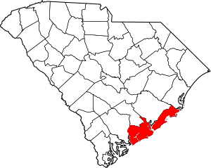
Location within the U.S. state of South Carolina
|
|||
 South Carolina's location within the U.S. |
|||
| Country | |||
| State | |||
| Founded | January 1, 1800 | ||
| Named for | King Charles II | ||
| Seat | Charleston | ||
| Largest community | Charleston | ||
| Area | |||
| • Total | 1,357.99 sq mi (3,517.2 km2) | ||
| • Land | 917.98 sq mi (2,377.6 km2) | ||
| • Water | 440.01 sq mi (1,139.6 km2) 32.40% | ||
| Population
(2020)
|
|||
| • Total | 408,235 | ||
| • Estimate
(2023)
|
424,367 | ||
| • Density | 444.71/sq mi (171.70/km2) | ||
| Time zone | UTC−5 (Eastern) | ||
| • Summer (DST) | UTC−4 (EDT) | ||
| Congressional districts | 1st, 6th | ||
Charleston County is a county in the U.S. state of South Carolina. It is located along the Atlantic coast. In 2020, about 408,235 people lived there. This makes it the third-most populated county in South Carolina.
The main city and county seat is Charleston. Charleston County is the largest county in South Carolina by total area. It was created in 1800. The county is part of the Charleston-North Charleston Metropolitan Area. It is also in the Lowcountry region of South Carolina.
Contents
History of Charleston County
Charleston County was first set up in 1785. But it was quickly closed down because people disagreed about how to run it. The county's borders were redrawn in 1798. These new borders officially started on January 1, 1800.
The county seat and largest city is Charleston. Both the county and the city are named after King Charles II of England.
Geography and Nature
Charleston County covers about 1,358 square miles. About 918 square miles are land, and 440 square miles are water. It is the largest county in South Carolina by its total land and water area.
Protected Natural Areas
Charleston County has many special places that are protected. These areas help keep nature safe.
- Cape Romain National Wildlife Refuge
- Charles Pinckney National Historic Site
- Ernest F. Hollings ACE Basin National Wildlife Refuge (part)
- Fort Sumter and Fort Moultrie National Historical Park
- Francis Marion National Forest (part)
- Little Wambaw Swamp Wilderness
- Wambaw Creek Wilderness (part)
- Wambaw Swamp Wilderness
Local Parks and Sites
There are also many state and local protected areas:
- Angel Oak Tree
- Bird Key - Stono Seabird Sanctuary
- Boone Hall Plantation & Gardens
- Botany Bay Plantation Heritage Preserve/Wildlife Management Area
- Buzzard Island Heritage Preserve
- Capers Island Heritage Preserve
- Crab Bank Seabird Sanctuary
- Charles Towne Landing State Historic Site
- Deveaux Bank Seabird Sanctuary
- Dungannon Plantation Heritage Preserve/Wildlife Management Area
- Edisto Beach State Park
- Folly Beach County Park
- Fort Lamar Heritage Preserve
- Hampton Plantation State Historic Site
- James Island County Park
- Lighthouse Inlet Heritage Preserve
- Magnolia Plantation and Gardens
- Morris Island Lighthouse
- North Charleston Wannamaker County Park
- Santee Coastal Reserve Wildlife Management Area
- Stono River County Park
- Waterfront Park
Rivers and Waterways
Many important rivers and water bodies are in Charleston County:
- Ashley River
- Atlantic Ocean
- Cooper River
- Intracoastal Waterway
- Kiawah River
- South Edisto River
- South Santee River
- Stono River
- Wando River
Neighboring Counties
Charleston County shares borders with these counties:
- Berkeley County – to the north
- Georgetown County – to the northeast
- Colleton County – to the west
- Dorchester County – to the northwest
Main Roads and Transport
Major highways that go through the county include:
Important transportation hubs are:
- Charleston International Airport (used by both civilians and the military)
- North Charleston Station (for trains)
- Port of Charleston (a major shipping port)
People of Charleston County
| Historical population | |||
|---|---|---|---|
| Census | Pop. | %± | |
| 1790 | 66,985 | — | |
| 1800 | 57,480 | −14.2% | |
| 1810 | 63,179 | 9.9% | |
| 1820 | 80,212 | 27.0% | |
| 1830 | 86,338 | 7.6% | |
| 1840 | 82,661 | −4.3% | |
| 1850 | 72,805 | −11.9% | |
| 1860 | 70,100 | −3.7% | |
| 1870 | 88,863 | 26.8% | |
| 1880 | 102,800 | 15.7% | |
| 1890 | 59,903 | −41.7% | |
| 1900 | 88,006 | 46.9% | |
| 1910 | 88,594 | 0.7% | |
| 1920 | 108,450 | 22.4% | |
| 1930 | 101,050 | −6.8% | |
| 1940 | 121,105 | 19.8% | |
| 1950 | 164,856 | 36.1% | |
| 1960 | 216,382 | 31.3% | |
| 1970 | 247,650 | 14.5% | |
| 1980 | 276,974 | 11.8% | |
| 1990 | 295,039 | 6.5% | |
| 2000 | 309,969 | 5.1% | |
| 2010 | 350,209 | 13.0% | |
| 2020 | 408,235 | 16.6% | |
| 2023 (est.) | 424,367 | 21.2% | |
| U.S. Decennial Census 1790–1960 1900–1990 1990–2000 2010 2020 |
|||
In 2020, there were 408,235 people living in Charleston County. There were over 165,000 households.
Population Makeup (2020)
The people living in Charleston County come from many different backgrounds.
| Race | Num. | Perc. |
|---|---|---|
| White (non-Hispanic) | 263,560 | 65.2% |
| Black or African American (non-Hispanic) | 91,746 | 26.3% |
| Native American | 857 | 0.4% |
| Asian | 7,461 | 1.83% |
| Pacific Islander | 319 | 0.08% |
| Other/Mixed | 15,012 | 3.68% |
| Hispanic or Latino | 29,280 | 5.3% |
Emergency Services
Charleston County has important services to help people in emergencies.
Volunteer Rescue Squad
The Volunteer Rescue Squad has over 50 members and a doctor. These members are trained in many emergency skills. Many are also first responders.
Hospitals and Medical Care
Emergency medical services (EMS) are provided by Charleston County and Berkeley County. Charleston is a major medical center for the eastern part of South Carolina.
There are several large hospitals in the downtown area:
- Medical University of South Carolina Medical Center (MUSC)
- Ralph H. Johnson VA Medical Center
- Roper Hospital
MUSC was the first medical school in South Carolina. It is also the largest medical university in the state. The downtown medical area is growing quickly. New biotechnology and medical research businesses are opening. Hospitals are also expanding. Other hospitals serving the area include Bon Secours-St Francis Xavier Hospital, Trident Medical Center, and East Cooper Medical Center.
Economy
In 2022, the total value of goods and services produced in Charleston County was about $41 billion. This means a lot of economic activity happens here. The unemployment rate has been low, usually between 2% and 3.3%.
Some of the biggest employers in the county include:
- Boeing (makes airplanes)
- Booz Allen Hamilton (consulting)
- Charleston County School District (schools)
- College of Charleston (university)
- CVS Pharmacy (drugstore)
- Harris Teeter (grocery store)
- Medical University of South Carolina (hospital and university)
- Mercedes-Benz Group (car manufacturing)
- Publix (grocery store)
- United States Department of Defense (military)
- United States Department of Veterans Affairs (veterans' services)
- Walmart (retail store)
Education
The Charleston County School District manages all the public schools in the county.
Fun and Recreation
The Charleston County Park and Recreation Commission (CCPRC) runs many fun places in the county.
Beach Parks
- Kiawah Beachwalker County Park, Kiawah Island, South Carolina
- Isle of Palms County Park, Isle of Palms, South Carolina
- Folly Beach County Park, Folly Beach, South Carolina
Fishing Piers
- Folly Beach Fishing Pier, Folly Beach, South Carolina
- Mt. Pleasant Pier, Mount Pleasant, South Carolina
Marinas and Boat Landings
- Cooper River Marina
- Many other boat landings around the county
Day Parks
- Palmetto Islands County Park, Mount Pleasant, South Carolina
- Caw Caw Nature and History Interpretive Center, Ravenel, South Carolina
- North Charleston Wannamaker County Park, North Charleston, South Carolina
- Mullet Hall Equestrian Center, Johns Island, South Carolina
- James Island County Park, Charleston, South Carolina
- Old Towne Creek County Park, West Ashley, Charleston, South Carolina
Water Parks
- Splash Island at Palmetto Islands County Park
- Splash Zone at James Island County Park
- Whirlin' Waters at North Charleston Wannamaker County Park
Many parks also have special areas where dogs can run off-leash. These are at James Island, Palmetto Islands, and North Charleston Wannamaker County Park.
James Island County Park is a big park near downtown Charleston. It has a 50-foot climbing wall and a bouldering cave. You can also camp there in cabins, RVs, or tents. The park offers kayaking, summer camps, and paved trails. It also hosts fun events like the Holiday Festival of Lights.
Communities
Charleston County has several cities, towns, and other communities.
Cities
- Charleston (the county seat and largest city)
- Folly Beach
- Isle of Palms
- North Charleston
Towns
- Awendaw
- Hollywood
- James Island
- Kiawah Island
- Lincolnville
- McClellanville
- Meggett
- Mount Pleasant
- Ravenel
- Rockville
- Seabrook Island
- Sullivan's Island
- Summerville
Census-Designated Places (CDPs)
These are areas that are like towns but are not officially incorporated.
Unincorporated Communities
These are areas that are not part of any city or town.
- Barrelville
- Edisto Island
- Johns Island
Population Ranking of Communities (2020 Census)
This table shows the largest communities in Charleston County by population. † = county seat
| Rank | Name | Type | Population (2020 census) |
|---|---|---|---|
| 1 | † Charleston | City | 150,227 |
| 2 | North Charleston | City | 114,852 |
| 3 | Mount Pleasant | Town | 90,801 |
| 4 | Summerville | Town | 50,915 |
| 5 | Ladson | CDP | 15,550 |
| 6 | James Island | Town | 11,621 |
| 7 | Hollywood | Town | 5,339 |
| 8 | Isle of Palms | City | 4,347 |
| 9 | Ravenel | Town | 2,542 |
| 10 | Folly Beach | City | 2,078 |
| 11 | Seabrook Island | Town | 2,050 |
| 12 | Kiawah Island | Town | 2,013 |
| 13 | Sullivan's Island | Town | 1,891 |
| 14 | Awendaw | Town | 1,399 |
| 15 | Meggett | Town | 1,390 |
| 16 | Lincolnville | Town | 1,147 |
| 17 | McClellanville | Town | 605 |
| 18 | Adams Run | CDP | 421 |
| 19 | Rockville | Town | 141 |
Notable People
- Pernessa C. Seele (born 1954), an immunologist who started the Balm in Gilead, Inc., an international organization.
See also
 In Spanish: Condado de Charleston para niños
 | Delilah Pierce |
 | Gordon Parks |
 | Augusta Savage |
 | Charles Ethan Porter |


