Seabrook Island, South Carolina facts for kids
Quick facts for kids
Seabrook Island, South Carolina
|
|
|---|---|
 |
|

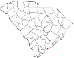
Location of Seabrook Island in South Carolina
|
|
| Country | United States |
| State | South Carolina |
| County | Charleston |
| Government | |
| • Type | Mayor-Council |
| Area | |
| • Total | 7.06 sq mi (18.29 km2) |
| • Land | 5.94 sq mi (15.38 km2) |
| • Water | 1.12 sq mi (2.91 km2) |
| Elevation | 5 ft (2 m) |
| Population
(2020)
|
|
| • Total | 2,050 |
| • Density | 345.23/sq mi (133.30/km2) |
| Time zone | UTC-5 (EST) |
| • Summer (DST) | UTC-4 (EDT) |
| ZIP code |
29455
|
| Area code(s) | 843, 854 |
| FIPS code | 45-64712 |
| GNIS feature ID | 1253570 |
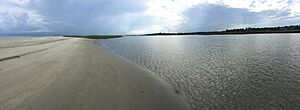
Seabrook Island, once called Simmons Island, is a special type of island known as a barrier island. It is located in Charleston County, South Carolina, in the United States. In 2020, about 2,050 people lived there.
Seabrook Island is part of the larger Charleston-North Charleston-Summerville metropolitan area. This means it's connected to the bigger cities nearby.
Contents
Exploring Seabrook Island's Location
Seabrook Island is in the southwestern part of Charleston County. It has the Atlantic Ocean to its south and the North Edisto River to its west. To the north, you'll find Bohicket Creek.
Just east of Seabrook Island, across the Kiawah River, is another town called Kiawah Island. Most of Seabrook's eastern side is next to undeveloped land. The big city of Charleston is about 25 miles (40 km) to the northeast.
The town of Seabrook Island covers a total area of about 7 square miles (18.1 square kilometers). Most of this area, about 6 square miles (15.5 square kilometers), is land. The rest, about 1.1 square miles (2.7 square kilometers), is water.
Seabrook Island's Weather and Climate
| Weather chart for Seabrook Island | |||||||||||||||||||||||||||||||||||||||||||||||
|---|---|---|---|---|---|---|---|---|---|---|---|---|---|---|---|---|---|---|---|---|---|---|---|---|---|---|---|---|---|---|---|---|---|---|---|---|---|---|---|---|---|---|---|---|---|---|---|
| J | F | M | A | M | J | J | A | S | O | N | D | ||||||||||||||||||||||||||||||||||||
|
2.9
57
43
|
2.5
60
46
|
3.3
65
52
|
2.5
72
59
|
2.2
79
67
|
4.7
85
74
|
5.4
88
77
|
6.7
86
76
|
5.8
82
72
|
3.7
75
63
|
2.2
67
54
|
2.6
60
46
|
||||||||||||||||||||||||||||||||||||
| temperatures in °F precipitation totals in inches source: NOAA |
|||||||||||||||||||||||||||||||||||||||||||||||
|
Metric conversion
|
|||||||||||||||||||||||||||||||||||||||||||||||
Seabrook Island has a humid subtropical climate. This means it has hot, humid summers and mild winters. Ocean breezes help keep the island's weather a bit milder than the nearby mainland.
In winter, daytime temperatures usually range from 55 to 60°F (13 to 16°C). Nighttime temperatures average 43 to 50°F (6 to 10°C). In summer, daytime highs are typically 85 to 88°F (29 to 31°C), with lows around 74 to 76°F (23 to 24°C).
The island gets about 48 inches (122 cm) of rain each year. It rarely snows or gets icy.
A Look Back: Seabrook Island's History
Early Explorers and Land Ownership
In 1666, a British explorer named Lt. Col. Robert Sanford arrived on Seabrook Island. He was working for King Charles II. By 1684, the local Stono Indians agreed to give their lands to the government. The government then sold the land to English settlers.
During the American Revolution, the island was a gathering spot for British troops. In 1816, William Seabrook bought the island. He was from nearby Edisto Island, and that's how Seabrook Island got its current name. Under his ownership, the island was used to grow cotton.
During the American Civil War, William Seabrook sold the island to William Gregg. Gregg then rented the land to Charles Andell.
The Kiawato Club and Later Changes
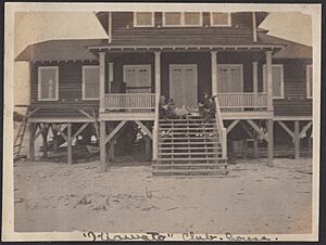
In 1917, the island was sold to a group of people who loved hunting, fishing, and other outdoor activities. They formed a club called the Kiawato Club. This name was a mix of Kiawah and Edisto, the two islands nearby. Their clubhouse was finished in 1918. It was a wooden building with bedrooms and a large dormitory.
In 1936, Victor Morawetz bought the club's land. He also bought more land from the Andell family in 1938.
In 1939, the Episcopal Diocese of South Carolina rented land on Seabrook. They used it to create a summer camp for children who needed help. In 1951, Mrs. Morawetz gave about 1,408 acres (5.7 square kilometers) of land, including the old Kiawato Clubhouse, to the church.
Modern Development and Community Life
In 1970, the church sold about 1,100 acres (4.5 square kilometers) to private developers. These developers planned the private, residential community that Seabrook Island is today. Seventeen years later, in 1987, the town of Seabrook was officially formed.
In 2005, it became a rule that new property owners on Seabrook Island had to become members of the Seabrook Island Club. This helped the island's economy grow. In 2010, the island finished a big project called the Horizon Plan. This project rebuilt many of the island's facilities.
Today, Seabrook Island has many great features for its residents and visitors. These include two championship golf courses and a racquet club with 15 tennis courts and two pickleball courts. There's also an equestrian center for horse riding, oceanfront restaurants, swimming pools, and a fitness center.
Who Lives on Seabrook Island?
| Historical population | |||
|---|---|---|---|
| Census | Pop. | %± | |
| 1880 | 50 | — | |
| 1990 | 948 | — | |
| 2000 | 1,250 | 31.9% | |
| 2010 | 1,714 | 37.1% | |
| 2020 | 2,050 | 19.6% | |
| U.S. Decennial Census | |||
The population of Seabrook Island has grown over the years. In 2000, there were 1,250 people. By 2010, it had grown to 1,714 people. In 2020, the population reached 2,050 people.
2020 Census Information
| Race | Num. | Perc. |
|---|---|---|
| White (non-Hispanic) | 1,983 | 96.73% |
| Black or African American (non-Hispanic) | 10 | 0.49% |
| Native American | 2 | 0.1% |
| Asian | 9 | 0.44% |
| Other/Mixed | 25 | 1.22% |
| Hispanic or Latino | 21 | 1.02% |
According to the 2020 United States census, there were 2,050 people living in Seabrook Island. These people made up 951 households and 703 families.
Schools on Seabrook Island
Seabrook Island is part of the Charleston County School District. Students living on the island typically attend Mount Zion Elementary School, Haut Gap Middle School, and St. John's High School.
See also
 In Spanish: Seabrook Island para niños
 | Precious Adams |
 | Lauren Anderson |
 | Janet Collins |


