Cooper River (South Carolina) facts for kids
Quick facts for kids Cooper River |
|
|---|---|

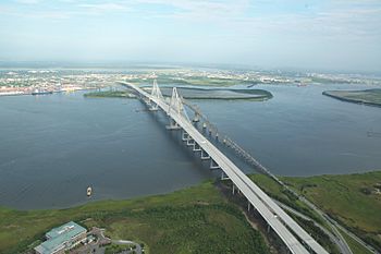
The Arthur Ravenel Jr. Bridge over the Cooper River in Charleston, South Carolina
|
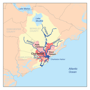
The Cooper River is a very important tidal river in the state of South Carolina, United States. A tidal river means its water levels go up and down with the ocean's tides. Many cities are located along this river, including Charleston, Mount Pleasant, and North Charleston.
The Cooper River is wide and not very long. It joins with the blackwater East Branch and then the Wando River. Soon after, the Cooper River gets even wider, forming an estuary (where fresh river water mixes with salty ocean water). It then meets the Ashley River to create the famous Charleston Harbor.
Contents
The Cooper River: A South Carolina Waterway
Where the River Flows
The Cooper River starts as a blackwater swamp in Berkeley County. Blackwater rivers get their dark color from decaying plants. The river's main water source now comes from Lake Moultrie. Lake Moultrie gets its water from Lake Marion through a special canal. This means the Cooper River and the Santee River systems are now connected.
A River with History
The Cooper River was named after Anthony Ashley Cooper, 1st Earl of Shaftesbury. He was a main owner of the Carolina Colony long ago. The city of Charleston was first started near the Ashley River in 1670. Ten years later, it moved to its current spot between the Ashley and Cooper rivers.
For a long time, people grew crops like rice and indigo on plantations along the Cooper River. Indigo is a plant used to make blue dye. Some of these old plantations are now historic sites. These include Lewisfield, Mulberry, and Middleburg. One plantation, Mepkin, is now Mepkin Abbey, a peaceful monastery. You can also visit Cypress Gardens and the Old Santee Canal Park nearby.
What You Can Find Along the River
Two islands, Daniel Island and Drum Island, are next to the river. Drum Island is not inhabited. Along the river's edge, you can see cargo terminals and a paper mill. The former Charleston Naval Base was also here.
At the mouth of the river is Patriot's Point. This is a naval and maritime museum. You can visit several museum ships there. The most famous is the USS Yorktown, a huge aircraft carrier from World War II.
A smaller river called Goose Creek flows into the Cooper River. This was once home to a U.S. Navy submarine base. It was used for submarines until the late 1990s.
Crossing the Cooper River
For many years, people crossed the Cooper River mainly by ferries. Then, bridges were built to make travel easier.
- The John P. Grace Memorial Bridge opened in 1929. It was built for cars and trucks.
- The Silas N. Pearman Bridge opened in 1966, right next to the Grace Bridge.
- The Don Holt Bridge was finished in 1992. It is a few miles upriver and is part of the I-526 highway.
Today, the main way to cross the river in the Charleston area is the Arthur Ravenel, Jr. Bridge. This amazing cable-stayed bridge opened in 2005. It replaced the older Grace and Pearman bridges, which were taken down. Every spring, a popular 10-kilometer running race called the Cooper River Bridge Run takes place across this bridge.
Further north, other bridges cross the river and its canals. The Dennis C. Bishop Bridge carries US 52 and US 17 Alternate traffic. There are also CSX railroad bridges that cross the river.
 | Chris Smalls |
 | Fred Hampton |
 | Ralph Abernathy |


