Ashley River (South Carolina) facts for kids

The Ashley River is a special river in South Carolina. It's a "blackwater" river, meaning its water looks dark like tea because of plants decaying in it. It's also a "tidal" river, which means its water level changes with the ocean tides.
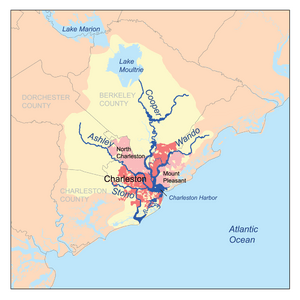
The river starts in swamps in western Berkeley County. It flows about 17 miles, passing by North Charleston. Near Charleston, it joins the Cooper River. Together, they form Charleston Harbor and then flow into the Atlantic Ocean.
Contents
History of the Ashley River
The Ashley River was named after Anthony Ashley Cooper, 1st Earl of Shaftesbury. He was a main owner of the Carolina Colony. Explorer Robert Sandford gave the river its name.
In 1670, the first permanent European settlement in South Carolina was built along this river. It was called Albemarle Point. Today, this spot is known as Charles Towne Landing. Ten years later, the settlement moved across the river to where Charleston is now.
Plantations and Crops
During the 1700s, wealthy landowners built large farms called plantations along the river. From 1780 to 1782, British soldiers took over these plantations during the American Revolutionary War.
Farmers on these plantations grew important crops. These included rice, indigo (a plant used to make blue dye), and cotton. After the American Civil War, many areas along the river became popular for hunting and tourism.
Exploring the Ashley River Today
The Ashley River area is full of history and natural beauty. About 22 miles of the river are a "State Scenic River." This means it's a special place protected for its beauty. This scenic part stretches from Summerville to Charleston.
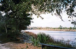
Along this section, you can see different environments. You can experience a blackwater swamp. You can also see the river's tides, which are influenced by the Atlantic Ocean.
Historic Sites to Visit
The Ashley River area has many historic places. There are 26 sites listed on the National Register of Historic Places. These are important places recognized for their history.
Some famous historic sites along the river include:
These sites offer a look into South Carolina's past.
 | Roy Wilkins |
 | John Lewis |
 | Linda Carol Brown |


