
Berkeley County, South Carolina facts for kids
Quick facts for kids
Berkeley County
|
|||
|---|---|---|---|

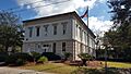
Old Berkeley County Courthouse
|
|||
|
|||
| Motto(s):
"One Berkeley"
"Rich History. Bright Future." |
|||

Location within the U.S. state of South Carolina
|
|||
 South Carolina's location within the U.S. |
|||
| Country | |||
| State | |||
| Founded | 1882 | ||
| Named for | Sir William Berkeley | ||
| Seat | Moncks Corner | ||
| Largest community | Goose Creek | ||
| Area | |||
| • Total | 1,233.88 sq mi (3,195.7 km2) | ||
| • Land | 1,103.62 sq mi (2,858.4 km2) | ||
| • Water | 130.26 sq mi (337.4 km2) 10.56% | ||
| Population
(2020)
|
|||
| • Total | 229,861 | ||
| • Estimate
(2023)
|
255,217 | ||
| • Density | 208.28/sq mi (80.42/km2) | ||
| Time zone | UTC−5 (Eastern) | ||
| • Summer (DST) | UTC−4 (EDT) | ||
| Congressional district | 1st | ||

Berkeley County is a county in the state of South Carolina. A county is like a smaller region within a state. In 2020, about 229,861 people lived here.
The main town, or county seat, is Moncks Corner. The biggest community is Goose Creek. Berkeley County was officially created in 1882. It is part of the larger Charleston area.
Contents
History of Berkeley County
Berkeley County was first set up in 1682. It was named after two important people, John and William Berkeley. They were part-owners of the Province of Carolina, which was a large area back then.
In 1769, the county became part of the Charleston District. For much of the 1800s, it didn't exist as a separate county. It was mostly known as part of the Low Country region.
After the Reconstruction era, the county was created again in 1882. Its first county seat was Mount Pleasant. Then, in 1895, the county seat moved to Moncks Corner. Berkeley County also has important ties to the American Revolutionary War.
The Old Berkeley County Courthouse is a historic building. It was added to the National Register of Historic Places in 1971.
Exploring Berkeley County's Geography
Berkeley County covers a total area of about 1,234 square miles. Most of this area, about 1,104 square miles, is land. The rest, about 130 square miles, is water. This means about 10.56% of the county is covered by water.
Protected Natural Areas
Berkeley County is home to several important natural spaces. These areas help protect wildlife and nature.
National Protected Lands
- Francis Marion National Forest (part)
- Hell Hole Bay Wilderness
- Wambaw Creek Wilderness (part)
State and Local Protected Sites
- Bonneau Ferry Wildlife Management Area
- Canal Wildlife Management Area
- Childsbury Towne Heritage Preserve
- Cypress Gardens
- Hatchery Wildlife Management Area
- Moultrie Hunt Unit Wildlife Management Area
- Old Santee Canal Park
- Site of Francis Marion Tomb
- Wee Tee Wildlife Management Area (part)
Major Waterways of Berkeley County
The county has many important rivers and lakes. These are great for nature and recreation.
- Cooper River
- Goose Creek Reservoir
- Lake Marion
- Lake Moultrie
- Santee River
- South Santee River
- Wambaw Creek
- Wando River
Neighboring Counties
Berkeley County shares borders with several other counties.
- Georgetown County – to the east
- Williamsburg County – to the northeast
- Clarendon County – to the north
- Orangeburg County – to the northwest
- Dorchester County – to the west
- Charleston County – to the south
Main Roads and Highways
Many important roads run through Berkeley County. These help people travel and transport goods.
 I-26
I-26 I-526
I-526
 US 17 Alt.
- Invalid type: US-Alt-Truck
 US 52
US 52 US 176
 SC 6
SC 6


SC 6 Truck SC 16
SC 16 SC 27
SC 27 SC 41
SC 41 SC 45
SC 45 SC 165
 SC 311
 SC 402
Key Infrastructure
- Seed Orchard Helibase
People of Berkeley County (Demographics)
| Historical population | |||
|---|---|---|---|
| Census | Pop. | %± | |
| 1890 | 55,428 | — | |
| 1900 | 30,454 | −45.1% | |
| 1910 | 23,487 | −22.9% | |
| 1920 | 22,558 | −4.0% | |
| 1930 | 22,236 | −1.4% | |
| 1940 | 27,128 | 22.0% | |
| 1950 | 30,251 | 11.5% | |
| 1960 | 38,196 | 26.3% | |
| 1970 | 56,199 | 47.1% | |
| 1980 | 94,727 | 68.6% | |
| 1990 | 128,776 | 35.9% | |
| 2000 | 142,651 | 10.8% | |
| 2010 | 177,843 | 24.7% | |
| 2020 | 229,861 | 29.2% | |
| 2023 (est.) | 255,217 | 43.5% | |
| U.S. Decennial Census 1790–1960 1900–1990 1990–2000 2010 2020 |
|||
Demographics tell us about the people living in a place. This includes how many people there are and their backgrounds.
2020 Census Information
| Race | Num. | Perc. |
|---|---|---|
| White (non-Hispanic) | 137,840 | 59.97% |
| Black or African American (non-Hispanic) | 51,784 | 22.53% |
| Native American | 1,035 | 0.45% |
| Asian | 5,353 | 2.33% |
| Pacific Islander | 173 | 0.08% |
| Other/Mixed | 13,348 | 5.81% |
| Hispanic or Latino | 20,328 | 8.84% |
In 2020, the county had 229,861 people. There were 80,640 households, which are groups of people living together. About 57,117 of these were families.
2010 Census Information
In 2010, there were 177,843 people living in Berkeley County. The population density was about 162 people per square mile. There were 65,419 households.
About 38% of households had children under 18. The average household had 2.66 people. The average age of people in the county was 34.5 years.
Berkeley County's Economy
The economy of Berkeley County is growing. In 2022, the total value of goods and services produced was about $10.6 billion. This is called the GDP. The unemployment rate has been around 3% from 2022 to 2024. This means most people who want jobs can find them.
Major Employers in Berkeley County
Many large companies have offices or factories here. These companies provide many jobs for the community.
Jobs and Wages by Industry
The table below shows how many people work in different types of jobs in Berkeley County. It also shows the average yearly pay for those jobs.
| Industry | Number of Jobs | Job Percentage (%) | Average Yearly Wage ($) |
|---|---|---|---|
| Hotels and Restaurants | 6,306 | 10.6 | 23,088 |
| Office Support and Waste Services | 2,507 | 4.2 | 41,756 |
| Farming, Fishing, and Hunting | 96 | 0.2 | 62,504 |
| Arts, Entertainment, and Fun | 1,031 | 1.7 | 28,808 |
| Building and Construction | 3,757 | 6.3 | 72,072 |
| Money and Insurance | 1,519 | 2.6 | 79,092 |
| Health Care and Social Help | 4,243 | 7.1 | 57,096 |
| Information Technology | 1,886 | 3.2 | 124,384 |
| Company Management | 376 | 0.6 | 95,680 |
| Manufacturing (Making Goods) | 9,406 | 15.8 | 79,976 |
| Mining and Quarrying | 132 | 0.2 | 78,156 |
| Other Services | 2,238 | 3.8 | 56,888 |
| Science and Technical Services | 5,911 | 9.9 | 91,988 |
| Government Jobs | 2,964 | 5.0 | 51,636 |
| Real Estate and Rentals | 889 | 1.5 | 75,556 |
| Retail Stores | 8,271 | 13.9 | 36,036 |
| Transportation and Storage | 3,881 | 6.5 | 59,956 |
| Utilities (Power, Water) | 1,517 | 2.6 | 92,560 |
| Wholesale Trade | 2,487 | 4.2 | 70,824 |
| Total | 59,417 | 100.0% | 62,118 |
Education in Berkeley County
All schools in Berkeley County are part of the Berkeley County School District. This district manages public education for students in the area.
Fun Places to Visit (Attractions)
Berkeley County has several interesting places to visit.
- Cypress Gardens
- Mepkin Abbey
- Berkeley County Museum and Heritage Center
Communities in Berkeley County
The county has different types of communities where people live.
Cities in Berkeley County
- Charleston (mostly in Charleston County)
- Goose Creek (This is the largest community in Berkeley County)
- Hanahan
- North Charleston (partly in Dorchester County and Charleston County)
Towns in Berkeley County
- Bonneau
- Jamestown
- Moncks Corner (This is the county seat, where the main county offices are)
- St. Stephen
- Summerville (partly in Dorchester County and Charleston County)
Census-Designated Places (CDPs)
These are areas that are like towns but are not officially incorporated as cities or towns.
- Bonneau Beach
- Ladson (partly in Charleston County and Dorchester County)
- Pimlico
- Pinopolis
- Russellville
- Sangaree
Unincorporated Communities
These are smaller areas that are not part of any city or town.
Images for kids
-
Old Berkeley County Courthouse
See also
 In Spanish: Condado de Berkeley (Carolina del Sur) para niños
