
Orangeburg County, South Carolina facts for kids
Quick facts for kids
Orangeburg County
|
|||
|---|---|---|---|

Old Orangeburg County Jail
|
|||
|
|||
| Motto(s):
"Community & Character"
|
|||

Location within the U.S. state of South Carolina
|
|||
 South Carolina's location within the U.S. |
|||
| Country | |||
| State | |||
| Founded | March 12, 1785 | ||
| Named for | William of Orange | ||
| Seat | Orangeburg | ||
| Largest community | Orangeburg | ||
| Area | |||
| • Total | 1,127.89 sq mi (2,921.2 km2) | ||
| • Land | 1,106.38 sq mi (2,865.5 km2) | ||
| • Water | 21.51 sq mi (55.7 km2) 1.91% | ||
| Population
(2020)
|
|||
| • Total | 84,223 | ||
| • Estimate
(2023)
|
82,820 | ||
| • Density | 76.12/sq mi (29.39/km2) | ||
| Time zone | UTC−5 (Eastern) | ||
| • Summer (DST) | UTC−4 (EDT) | ||
| Congressional districts | 2nd, 6th | ||


Orangeburg County is a county in the state of South Carolina. In 2020, about 84,223 people lived there. Its main town, or county seat, is Orangeburg. The county was first created in 1769.
Orangeburg County is part of a larger area called the Orangeburg, South Carolina Micropolitan Statistical Area. It is also included in the Columbia-Sumter-Orangeburg Combined Statistical Area. The county is located in the central part of South Carolina, known as the Midlands.
This county is home to two important universities. South Carolina State University is the only public four-year historically Black university in the state. Claflin University is the oldest historically Black college or university (HBCU) in South Carolina.
Contents
History of Orangeburg County
For thousands of years, Native American tribes lived in this area. When Europeans arrived, tribes like the Cheraw, Catawba, and Pedee lived in the Piedmont region.
European settlers officially created the Orangeburg Judicial District in 1769. This area was mostly undeveloped land between the Congaree and Savannah rivers. After the American Revolutionary War, a county named Orange was formed but later dissolved in 1791.
Over time, parts of Orangeburg District were separated to form new counties. In 1800, the southwest part became Barnwell District. In 1804, the northern part became Lexington District. A smaller piece was added to Lexington District in 1832.
During the 19th century, the county became known for growing cotton on large farms called plantations. This happened after the cotton gin was invented, which made it easier to process cotton. Many enslaved Black people were brought to the county to work on these plantations. They came from coastal areas and other parts of the South.
After the American Civil War, during the Reconstruction era, South Carolina changed its laws. In 1868, districts became counties, and people could vote for their state representatives. This allowed more male residents, including newly freed Black men, to vote. However, by the end of the century, white politicians passed new laws that stopped most Black people from voting. This unfair situation lasted until the 1965 Voting Rights Act was passed.
More changes to the county's borders happened later. In 1871, a small western part of Orangeburg County was added to the new Aiken County. In 1908, the northern part along the Congaree River became part of Calhoun County. Finally, in 1910, a small piece of Berkeley County was added to Orangeburg County, making it the size it is today.
Geography of Orangeburg County

Orangeburg County is quite large. It covers about 1,128 square miles. This makes it the second-largest county in South Carolina by land area. It stretches about 60 miles from its western to its eastern side.
The county is located in three different regions of South Carolina. The western part is in the "Central Savannah River Area" (CSRA). The middle part is in the "Midlands" region. The eastern and southeastern parts are in the "Lowcountry" region.
National Protected Areas
State and Local Protected Areas
- Santee Cooper Wildlife Management Area
- Indian Bluff Recreation Park
- Santee State Park
Major Water Bodies
- Congaree River
- Cooper River
- Edisto River
- Four Hole Swamp
- Lake Marion
- North Fork Edisto River
- South Fork Edisto River
Adjacent Counties
- Calhoun County – north
- Clarendon County – northeast
- Dorchester County – southeast
- Berkeley County – southeast
- Bamberg County – south
- Colleton County – south
- Aiken County – west
- Barnwell County – west
- Lexington County – northwest
Population of Orangeburg County
| Historical population | |||
|---|---|---|---|
| Census | Pop. | %± | |
| 1790 | 18,513 | — | |
| 1800 | 15,766 | −14.8% | |
| 1810 | 13,229 | −16.1% | |
| 1820 | 15,653 | 18.3% | |
| 1830 | 18,453 | 17.9% | |
| 1840 | 18,519 | 0.4% | |
| 1850 | 23,582 | 27.3% | |
| 1860 | 24,896 | 5.6% | |
| 1870 | 16,865 | −32.3% | |
| 1880 | 41,395 | 145.4% | |
| 1890 | 49,393 | 19.3% | |
| 1900 | 59,663 | 20.8% | |
| 1910 | 55,893 | −6.3% | |
| 1920 | 64,907 | 16.1% | |
| 1930 | 63,864 | −1.6% | |
| 1940 | 63,707 | −0.2% | |
| 1950 | 68,726 | 7.9% | |
| 1960 | 68,559 | −0.2% | |
| 1970 | 69,789 | 1.8% | |
| 1980 | 82,276 | 17.9% | |
| 1990 | 84,803 | 3.1% | |
| 2000 | 91,582 | 8.0% | |
| 2010 | 92,501 | 1.0% | |
| 2020 | 84,223 | −8.9% | |
| 2023 (est.) | 82,820 | −10.5% | |
| U.S. Decennial Census 1790–1960 1900–1990 1990–2000 2010 2020 |
|||
What the 2020 Census Shows
| Race | Num. | Perc. |
|---|---|---|
| White (non-Hispanic) | 27,787 | 32.99% |
| Black or African American (non-Hispanic) | 50,802 | 60.32% |
| Native American | 467 | 0.55% |
| Asian | 892 | 1.06% |
| Pacific Islander | 37 | 0.04% |
| Other/Mixed | 2,271 | 2.7% |
| Hispanic or Latino | 1,967 | 2.34% |
In 2020, the county had 84,223 people. There were 32,129 households and 20,620 families living there.
What the 2010 Census Showed
In 2010, there were 92,501 people in Orangeburg County. About 62.2% of the people were Black or African American. About 34.3% were White. Other groups made up smaller parts of the population. About 1.9% of the people were of Hispanic or Latino background.
Economy of Orangeburg County
Orangeburg County is one of the biggest farming counties in South Carolina. The land is good for growing crops. Main crops include cotton, soybeans, corn, turf grass, and watermelons.
-
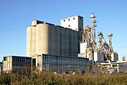
Grain elevator in the county
-
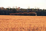
Soybeans ready for harvest, with center pivot irrigation setup
-
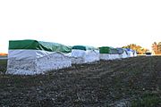
Harvested cotton in modules ready for pickup


In 2022, the total value of all goods and services produced in the county was about $3.4 billion. This shows how much economic activity happens there.
Some of the largest employers in Orangeburg County include:
- Claflin University
- GPM Investments
- Husqvarna Group
- Love's
- Medical University of South Carolina
- Orangeburg–Calhoun Technical College
- South Carolina State University
- Okonite
- Walmart
The table below shows how many people work in different industries in Orangeburg County and what their average yearly wages are. This data is from late 2023.
| Industry | Employment Counts | Employment Percentage (%) | Average Annual Wage ($) |
|---|---|---|---|
| Accommodation and Food Services | 3,146 | 11.2 | 19,968 |
| Administrative and Support and Waste Management and Remediation Services | 860 | 3.1 | 29,224 |
| Agriculture, Forestry, Fishing and Hunting | 479 | 1.7 | 46,072 |
| Arts, Entertainment, and Recreation | 308 | 1.1 | 19,292 |
| Construction | 740 | 2.6 | 64,272 |
| Educational Services | 3,228 | 11.5 | 48,464 |
| Finance and Insurance | 460 | 1.6 | 55,068 |
| Health Care and Social Assistance | 3,973 | 14.2 | 35,516 |
| Information | 119 | 0.4 | 61,880 |
| Manufacturing | 4,839 | 17.3 | 63,960 |
| Other Services (except Public Administration) | 446 | 1.6 | 37,336 |
| Professional, Scientific, and Technical Services | 508 | 1.8 | 53,768 |
| Public Administration | 1,520 | 5.4 | 49,712 |
| Real Estate and Rental and Leasing | 176 | 0.6 | 43,524 |
| Retail Trade | 4,074 | 14.6 | 29,796 |
| Transportation and Warehousing | 1,910 | 6.8 | 56,472 |
| Utilities | 321 | 1.1 | 72,436 |
| Wholesale Trade | 890 | 3.2 | 49,920 |
| Total | 27,997 | 100.0% | 43,840 |
Transportation in Orangeburg County
Major Highways
Railroads
Several train lines cross Orangeburg County. These include a former Southern Railway line and three CSX lines.
Major Infrastructure
- North Air Force Auxiliary Field
- Orangeburg Municipal Airport
Communities in Orangeburg County
City
- Orangeburg (This is the county seat and the largest community.)
Towns
Census-Designated Places
- Brookdale
- Edisto
- Wilkinson Heights
State-Recognized Tribes
Orangeburg County is home to two Native American tribes that are recognized by the state of South Carolina.
- The Beaver Creek Indian Tribe is based in Salley. They are a non-profit organization and were recognized by South Carolina in 2006. Most of their members live in Aiken County. This tribe is not recognized by the U.S. federal government.
- The Santee Indian Organization is based in Holly Hill. They are also a non-profit organization and were recognized by South Carolina in 2006. They say they are descendants of the historic Santee people. This tribe is not recognized by the U.S. federal government.
See also
 In Spanish: Condado de Orangeburg para niños
