Aiken County, South Carolina facts for kids
Quick facts for kids
Aiken County
|
||
|---|---|---|

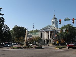
Aiken County Courthouse and Confederate Monument
|
||
|
||

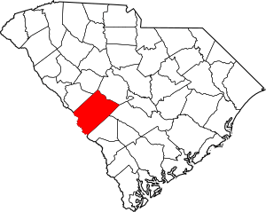
Location within the U.S. state of South Carolina
|
||
 South Carolina's location within the U.S. |
||
| Country | ||
| State | ||
| Founded | 1871 | |
| Named for | William Aiken | |
| Seat | Aiken | |
| Largest community | Aiken | |
| Area | ||
| • Total | 1,080.17 sq mi (2,797.6 km2) | |
| • Land | 1,070.69 sq mi (2,773.1 km2) | |
| • Water | 9.48 sq mi (24.6 km2) 0.88% | |
| Population
(2020)
|
||
| • Total | 168,808 | |
| • Estimate
(2023)
|
177,130 | |
| • Density | 157.66/sq mi (60.87/km2) | |
| Time zone | UTC−5 (Eastern) | |
| • Summer (DST) | UTC−4 (EDT) | |
| Congressional district | 2nd | |
Aiken County is a county in the state of South Carolina. In 2020, about 168,808 people lived here. The main town and largest community is Aiken. Aiken County is part of the larger Augusta, Georgia-South Carolina area. Most of the county is in the Sandhills region. Some northern parts reach into the Piedmont, and southern parts extend into the Coastal Plain.
History
How Aiken County Began
Aiken County was formed in 1871 during a time called the Reconstruction era. This was after the Civil War. It was created from parts of four other counties: Barnwell, Edgefield, Lexington, and Orangeburg.
The county and its main town, Aiken, are named after William Aiken (1779–1831). He was the first president of the South Carolina Railroad Company.
Early Settlers
In the early days, many farmers moved to this area from England. They came from places like Lincolnshire, Nottinghamshire, and Derbyshire. Most arrived as indentured servants, meaning they worked for a period to pay for their travel. After that, they often started their own small farms.
Some Scottish-Irish families also settled here. They came from Ireland in the 1740s. Many of these early settlers fought for the American side in the Revolutionary War.
Important Leaders
Several important people helped create Aiken County. Prince Rivers, a formerly enslaved person and state legislator, led the group that drew the county's borders. He also helped choose where the courthouse would be built.
Other key figures included Samuel J. Lee, who was the first Black lawyer allowed to practice in South Carolina. Charles D. Hayne, a free man of color from a well-known family, also played a role.
Challenges and Changes
The 1870s were a time of tension in South Carolina. Before the 1876 elections, there was violence in Aiken County. Groups like the "Red Shirts" attacked Black Republicans to stop them from voting. Sadly, many Black men were killed during this time.
Later, in the late 1800s, Aiken County became a popular winter spot. Wealthy people from the North built fancy homes here. It's still a favorite place for horse trainers and riders today because of its mild winters.
The Savannah River Site
In the 1950s, Aiken County was chosen for a big project called the Savannah River Site. This site was used to store and produce nuclear materials during the Cold War. A town called Ellenton was moved to make way for this facility. Its residents moved to new towns like New Ellenton and Jackson. Parts of the site are now being cleaned up and closed down.
Geography
Aiken County covers about 1,080 square miles. Most of this (about 1,070 square miles) is land, and a small part (about 9.5 square miles) is water. It is the fourth-largest county in South Carolina by land area.
Protected Areas and Sites
Aiken County has many natural and historic places, including:
- Aiken Gopher Tortoise Heritage Preserve/Wildlife Management Area
- Aiken State Park
- Audubon's Silver Bluff Center and Sanctuary
- Redcliffe Plantation State Historic Site
Major Water Bodies
Important rivers and creeks in the county include:
Neighboring Counties
Aiken County shares borders with these counties:
- Saluda County – north
- Lexington County – northeast
- Orangeburg County – east
- Barnwell County – south
- Burke County, Georgia – southwest
- Edgefield County – west
- Richmond County, Georgia – west
Major Roads
 I-20
I-20 I-520
I-520 US 1
US 1 US 25
US 25 US 78
US 78 US 278
 SC 4
SC 4 SC 19
SC 19 SC 34
SC 34 SC 39
SC 39 SC 121
 SC 125
 SC 302
Major Infrastructure
- Aiken Regional Airport
- Savannah River Site (part)
Demographics
| Historical population | |||
|---|---|---|---|
| Census | Pop. | %± | |
| 1880 | 28,112 | — | |
| 1890 | 31,822 | 13.2% | |
| 1900 | 39,032 | 22.7% | |
| 1910 | 41,849 | 7.2% | |
| 1920 | 45,574 | 8.9% | |
| 1930 | 47,403 | 4.0% | |
| 1940 | 49,916 | 5.3% | |
| 1950 | 53,137 | 6.5% | |
| 1960 | 81,038 | 52.5% | |
| 1970 | 91,023 | 12.3% | |
| 1980 | 105,625 | 16.0% | |
| 1990 | 120,940 | 14.5% | |
| 2000 | 142,552 | 17.9% | |
| 2010 | 160,099 | 12.3% | |
| 2020 | 168,808 | 5.4% | |
| 2023 (est.) | 177,130 | 10.6% | |
| U.S. Decennial Census 1790–1960 1900–1990 1990–2000 2010 2020 |
|||
Population in 2020
| Race | Num. | Perc. |
|---|---|---|
| White (non-Hispanic) | 107,918 | 63.93% |
| Black or African American (non-Hispanic) | 39,465 | 23.38% |
| Native American | 530 | 0.31% |
| Asian | 1,773 | 1.05% |
| Pacific Islander | 96 | 0.06% |
| Other/Mixed | 7,500 | 4.44% |
| Hispanic or Latino | 11,526 | 6.83% |
In 2020, Aiken County had 168,808 people living in 67,889 households. About 43,932 of these were families. The county is home to a diverse population.
Population in 2010
In 2010, the county's population was 160,099 people. The population density was about 149.5 people per square mile. The racial makeup of the county included about 69.6% white people and 24.6% Black or African American people. About 4.9% of the population was of Hispanic or Latino origin.
The average age of people in Aiken County in 2010 was 40 years old. The median income for a household was about $44,468. For families, the median income was around $57,064.
Economy
In 2022, the total value of goods and services produced in Aiken County (called GDP) was about $8.6 billion. This means the county's economy is quite strong. The unemployment rate has been around 3% in recent years.
Some of the largest employers in Aiken County include:
- Aiken Regional Medical Center
- Bridgestone
- Hubbell Incorporated
- Kimberly-Clark
- Savanah River Nuclear Solutions (SRNS)
- Shaw Industries
- UPS
- Walmart
| Industry | Employment Counts | Employment Percentage (%) | Average Annual Wage ($) |
|---|---|---|---|
| Accommodation and Food Services | 6,332 | 9.9 | 19,136 |
| Administrative and Support and Waste Management and Remediation Services | 9,749 | 15.2 | 87,516 |
| Agriculture, Forestry, Fishing and Hunting | 246 | 0.4 | 53,404 |
| Arts, Entertainment, and Recreation | 1,115 | 1.7 | 21,424 |
| Construction | 5,781 | 9.0 | 82,316 |
| Educational Services | 4,313 | 6.7 | 52,572 |
| Finance and Insurance | 1,011 | 1.6 | 67,808 |
| Health Care and Social Assistance | 7,217 | 11.2 | 49,972 |
| Information | 458 | 0.7 | 62,400 |
| Management of Companies and Enterprises | 114 | 0.2 | 92,612 |
| Manufacturing | 8,739 | 13.6 | 71,448 |
| Mining, Quarrying, and Oil and Gas Extraction | 138 | 0.2 | 73,684 |
| Other Services (except Public Administration) | 1,693 | 2.6 | 46,436 |
| Professional, Scientific, and Technical Services | 3,388 | 5.3 | 102,908 |
| Public Administration | 2,564 | 4.0 | 63,024 |
| Real Estate and Rental and Leasing | 462 | 0.7 | 48,984 |
| Retail Trade | 7,320 | 11.4 | 31,824 |
| Transportation and Warehousing | 2,417 | 3.8 | 52,260 |
| Utilities | 374 | 0.6 | 86,372 |
| Wholesale Trade | 825 | 1.3 | 60,060 |
| Total | 64,256 | 100.0% | 60,220 |
Education
Aiken County has several educational institutions:
- Aiken County Public School District
- Aiken Technical College
- University of South Carolina Aiken
Communities
Cities
- Aiken (county seat and largest community)
- New Ellenton
- North Augusta (partly in Edgefield County)
Towns
Census-designated places
Unincorporated communities
- Bath
- Beech Island
- Eureka
- New Holland
- Seivern
- Spiderweb
- Talatha
- White Pond
- Vaucluse
Historic places
- Aiken Tennis Club
- Hamburg
- Whitehall
- Palmetto Golf Club
- Whitney Field, Polo, Oldest in United States
- Hitchcock Woods
See also
 In Spanish: Condado de Aiken para niños
 | Anna J. Cooper |
 | Mary McLeod Bethune |
 | Lillie Mae Bradford |


