Burnettown, South Carolina facts for kids
Quick facts for kids
Burnettown, South Carolina
|
|
|---|---|

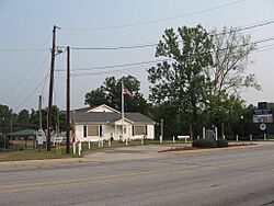
Former Burnettown Town Hall
|
|

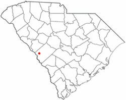
Location of Burnettown, South Carolina
|
|
| Country | |
| State | |
| County | |
| Area | |
| • Total | 6.05 sq mi (15.67 km2) |
| • Land | 5.51 sq mi (14.27 km2) |
| • Water | 0.54 sq mi (1.40 km2) |
| Elevation | 180 ft (50 m) |
| Population
(2020)
|
|
| • Total | 3,105 |
| • Density | 563.52/sq mi (217.59/km2) |
| Time zone | UTC-5 (Eastern (EST)) |
| • Summer (DST) | UTC-4 (EDT) |
| ZIP code |
29851
|
| Area code(s) | 803, 839 |
| FIPS code | 45-10270 |
| GNIS feature ID | 1231108 |
Burnettown is a small town in Aiken County, South Carolina, USA. In 2020, about 3,105 people lived there. It's part of the larger Augusta, Georgia metropolitan area, which includes nearby cities. Burnettown is found in the historic Horse Creek Valley.
Contents
Where is Burnettown Located?
Burnettown is in the western part of Aiken County. You can find its exact spot using these coordinates: 33°30′44″N 81°52′14″W / 33.51222°N 81.87056°W. It sits along two important roads, U.S. Route 1 and 78.
The town is about 7 miles (11 km) east of downtown Augusta, Georgia. It is also about 10 miles (16 km) west of Aiken. Burnettown is surrounded by other communities. These include Clearwater to the west and North Augusta to the northwest. To the east are Gloverville and Langley. The community of Bath is to the south.
The town covers a total area of about 6.0 square miles (15.6 square kilometers). Most of this area, about 5.5 square miles (14.2 sq km), is land. The rest, about 0.5 square miles (1.4 sq km), is water. This water mostly comes from Langley Pond, which is a reservoir on Horse Creek.
Who Lives in Burnettown?
This section looks at the number of people living in Burnettown over the years. It also shows different groups of people who make up the town's population.
Population Changes Over Time
| Historical population | |||
|---|---|---|---|
| Census | Pop. | %± | |
| 1950 | 578 | — | |
| 1960 | 510 | −11.8% | |
| 1970 | 434 | −14.9% | |
| 1980 | 359 | −17.3% | |
| 1990 | 493 | 37.3% | |
| 2000 | 2,720 | 451.7% | |
| 2010 | 2,673 | −1.7% | |
| 2020 | 3,105 | 16.2% | |
| U.S. Decennial Census | |||
The population of Burnettown has changed quite a bit over the decades. In 1950, there were 578 people. The number went down for a while, reaching 359 in 1980. Then, it grew a lot, especially between 1990 and 2000. By 2020, the population was 3,105.
Burnettown in 2010
In 2010, the town had 2,673 residents. Most people, about 78%, were white. About 14% were African American. Smaller groups included Asian people (0.75%) and Native Americans (0.64%). About 6.4% of the population identified as Hispanic or Latino. The population was almost evenly split between males (50.17%) and females (49.83%).
The age groups were also recorded. About 6% of the people were under 5 years old. Around 17% were between 5 and 17 years old. The largest group, about 61%, was between 18 and 64 years old. About 16% of the residents were 65 years or older.
Burnettown in 2020
As of the 2020 United States census, Burnettown had 3,105 people. There were 1,080 households, which means 1,080 different homes where people lived. Out of these, 734 were families.
The table below shows the different racial groups in Burnettown in 2020:
| Race | Number of People | Percentage |
|---|---|---|
| White (not Hispanic or Latino) | 2,021 | 65.09% |
| Black or African American (not Hispanic or Latino) | 658 | 21.19% |
| Native American | 12 | 0.39% |
| Asian | 24 | 0.77% |
| Pacific Islander | 1 | 0.03% |
| Other/Mixed (two or more races) | 141 | 4.54% |
| Hispanic or Latino | 248 | 7.99% |
Schools in Burnettown
Students in Burnettown attend schools within the Aiken County Public School District. For younger students, parts of Burnettown are in the attendance zones for Clearwater, Gloverville, and Jefferson elementary schools.
Middle school students from Burnettown go to either LBC Middle School or Leavelle McCampbell Middle School. All high school students living in Burnettown attend Midland Valley High School.
See also
 In Spanish: Burnettown para niños
 | Sharif Bey |
 | Hale Woodruff |
 | Richmond Barthé |
 | Purvis Young |

