St. Stephen, South Carolina facts for kids
Quick facts for kids
St. Stephen, South Carolina
|
|
|---|---|

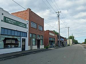
Downtown St. Stephen, SC
|
|
| Nickname(s):
Town across the way
|
|

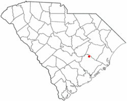
Location of St. Stephen, South Carolina
|
|
| Country | United States |
| State | South Carolina |
| County | Berkeley |
| Area | |
| • Total | 2.42 sq mi (6.27 km2) |
| • Land | 2.42 sq mi (6.27 km2) |
| • Water | 0.00 sq mi (0.00 km2) |
| Elevation | 79 ft (24 m) |
| Population
(2020)
|
|
| • Total | 1,571 |
| • Density | 649.44/sq mi (250.74/km2) |
| Time zone | UTC-5 (Eastern (EST)) |
| • Summer (DST) | UTC-4 (EDT) |
| ZIP code |
29479
|
| Area code(s) | 843 and 854 |
| FIPS code | 45-62755 |
| GNIS feature ID | 1250704 |
St. Stephen is a small town located in Berkeley County, South Carolina, in the United States. It's a friendly place with a population of about 1,571 people, according to the 2020 census. The town is part of the larger Charleston-North Charleston-Summerville metropolitan area, which means it's connected to bigger cities nearby.
Contents
History of St. Stephen
St. Stephen has a rich history, with some important places recognized for their past. Two of these, the Keller Site and St. Stephen's Episcopal Church, are listed on the National Register of Historic Places. This list includes buildings, sites, and objects that are important in American history.
Historic Places to See
- The Keller Site: This is an archaeological site that tells us about the people who lived in this area a very long time ago.
- St. Stephen's Episcopal Church: This church is a beautiful old building that has been a part of the community for many years. It shows us what architecture was like in the past.
Geography and Location
St. Stephen is found in the northern part of Berkeley County. It's located between two important water bodies: Lake Moultrie to its west and the Santee River to its northeast. The town also sits right next to the western edge of the Francis Marion National Forest. This forest is a huge natural area with lots of trees and wildlife.
Getting Around St. Stephen
The main road that goes through St. Stephen is U.S. Route 52. This road can take you north about 25 miles to Kingstree or south about 17 miles to Moncks Corner. Moncks Corner is important because it's the main town for Berkeley County. Another road, South Carolina Highway 45, crosses US 52 in the middle of town. This highway leads west to Eutawville and southeast towards McClellanville, which is close to the Atlantic Ocean.
Size of the Town
The town of St. Stephen covers a total area of about 2.42 square miles (6.2 square kilometers). All of this area is land, meaning there are no large lakes or rivers within the town limits.
Population and People
The population of St. Stephen has changed over the years. In 2020, there were 1,571 people living in the town. These people made up 648 households, with 397 of those being families.
Population Changes Over Time
Here's a quick look at how the population of St. Stephen has grown and changed through the years:
- 1880: 79 people
- 1900: 256 people
- 1920: 312 people
- 1940: 1,185 people
- 1960: 1,462 people
- 1980: 1,850 people
- 2000: 1,776 people
- 2010: 1,697 people
- 2020: 1,571 people
Who Lives in St. Stephen?
The people living in St. Stephen come from different backgrounds. Here's a look at the racial makeup of the town from the 2020 census:
- White (non-Hispanic): About 41.82%
- Black or African American (non-Hispanic): About 51.56%
- Native American: About 0.45%
- Asian: About 0.45%
- Pacific Islander: About 0.06%
- Other/Mixed races: About 4.52%
- Hispanic or Latino: About 1.15%
Education in St. Stephen
For students and residents, St. Stephen has a public library. This library is a part of the Berkeley County Library System. It offers books, resources, and a quiet place to learn for everyone in the community.
See also
 In Spanish: St. Stephen (Carolina del Sur) para niños
 | James B. Knighten |
 | Azellia White |
 | Willa Brown |

