
Waterfront Park (Charleston) facts for kids
Quick facts for kids Waterfront Park |
|
|---|---|
 |
|
| Location | Charleston, South Carolina |
| Area | 12 acres (4.9 ha) |
| Created | 1990 |
Waterfront Park is a beautiful eight-acre (about 5 hectares) park located along the Cooper River in Charleston, South Carolina. It stretches for about half a mile along the riverbank. In 2007, the park won a special award called the Landmark Award. This award celebrates older park designs that are still great and help the community.
Contents
Park History
For a long time, the area where Waterfront Park now stands was a busy place for ships and boats. It had many docks and shipping areas. Over the years, this area became less active and started to decline. In 1955, a big fire at a shipping terminal made things worse. By 1980, the site was mostly an overgrown area with old, burned pilings and gravel parking lots.
Bringing the Park to Life
Charleston's Mayor, Joseph P. Riley, Jr., started planning for a park here soon after he became mayor in 1975. The city began buying the land in 1979. After more than ten years of planning and raising money, construction finally began in 1988.
Work on the $13 million park continued into 1989. The park was set to open on May 4, 1990. However, in September 1989, Hurricane Hugo hit Charleston. The hurricane caused about $1 million in damage to the park. Even with the damage, the park still opened on May 11, 1990, just one week later than planned!
Park Design and Features
The park was designed by Stuart O. Dawson and his team. It has won many awards for its beautiful design. The park is made up of several different sections, each with its own special features.
Northern Entrance and Pier
At the northern entrance of the park, near Vendue Range street, there is a large fountain. This fountain marks the beginning of the park. From here, you can walk onto Vendue Wharf, which is a wide, wooden pier that extends into the Cooper River.
The pier has sheltered swings where you can relax and enjoy the view. At the very end of the pier, there is a floating dock. From this dock, you can see amazing sights like the Ravenel Bridge, Charleston Harbor, Castle Pinckney, the U.S.S. Yorktown at Patriot's Point, and Fort Sumter. You can still see some of the charred pilings from the 1955 fire in the river near the pier.
Central Park Area
The largest part of the park is located between Vendue Range and Exchange Street. This section has two main areas. One part runs along Concord Street and Prioleau Street. It has a thick canopy of oak trees, providing lots of shade and many benches for sitting.
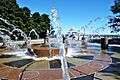
Next to this shady area, closer to the river, is a large open lawn with palmetto trees. A 1,200-foot walkway, called an esplanade, follows the natural edge of the water. This ensures everyone can easily access the riverfront. In the middle of the grassy lawn, you'll find the famous Pineapple Fountain. This large fountain is shaped like a pineapple and is located right in front of the City Gallery.
Southern End and Salt Marshes
At the southern end of the park, the walkway curves along the shore and then turns back toward Concord Street. Near Exchange Street, the park blends into restored salt marshes. These marshes are important natural areas that provide a home for many plants and animals that live in the water.
You can walk right up to the river's edge from Exchange Street to North Adger's Wharf. At the end of North Adger's Wharf, a 17th-century pier was rebuilt using its original design. The granite stones for the pier were even pulled out of the river and reused! This pier was built using strong native palmetto trees to make sure it lasts for many generations. This pier marks the southern edge of Waterfront Park.
Images for kids
-
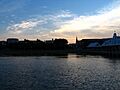
At sunset
-
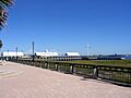
The pier and shelters
-
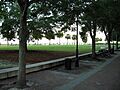
Looking south-southeast from the main fountain
-
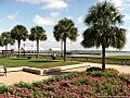
Looking toward the Cooper River
-
Waterfront Park


