
Sullivan's Island, South Carolina facts for kids
Quick facts for kids
Sullivan's Island, South Carolina
|
|
|---|---|

Sullivan's Island viewed from Fort Moultrie
|
|
| Country | United States |
| State | South Carolina |
| County | Charleston |
| Settled | 17th century (as O'Sullivan's Island) |
| Named for | Captain Florence O'Sullivan |
| Area | |
| • Total | 3.44 sq mi (8.91 km2) |
| • Land | 2.50 sq mi (6.47 km2) |
| • Water | 0.94 sq mi (2.44 km2) |
| Elevation | 9 ft (3 m) |
| Population
(2020)
|
|
| • Total | 1,891 |
| • Density | 757.01/sq mi (292.28/km2) |
| Time zone | UTC−5 (EST) |
| • Summer (DST) | UTC−4 (EDT) |
| ZIP code |
29482
|
| Area code(s) | 843, 854 |
| FIPS code | 45-70090 |
| GNIS feature ID | 1231842 |
Sullivan's Island is a small town and island in Charleston County, South Carolina, United States. It sits right at the entrance to Charleston Harbor. In 2020, about 1,891 people lived there. The town is part of the larger Charleston area.
Sullivan's Island has a very important, but sad, history. It was the main entry point for about 40 to 50 percent of the 400,000 enslaved Africans who were brought to Colonial America. This means that many African Americans today have ancestors who first arrived in America through this island. It's sometimes compared to Ellis Island, which was a major entry point for immigrants in New York City in the 1800s.
During the American Revolution, the island was the site of a big battle on June 28, 1776. This battle happened at a place called Fort Sullivan, which was later renamed Fort Moultrie. The new name honored the American commander, William Moultrie.
More recently, on September 23, 1989, Hurricane Hugo hit the island very hard. The center of the hurricane passed right over Sullivan's Island. The Ben Sawyer Bridge, which connects the island to the mainland, was badly damaged. One end of the bridge fell into the water, and the other pointed up to the sky. The police chief, Jack Lilien, was the last person to leave the island before the bridge broke.
Contents
History of Sullivan's Island

The island was first known as O'Sullivan's Island. It was named after Captain Florence O'Sullivan. He was a lighthouse keeper there in the late 1600s. Captain O'Sullivan was in charge of one of the ships that brought the first English and Irish settlers to Charleston. In 1671, he became a surveyor general, meaning he helped map out the land. He was one of the first Irish immigrants to arrive in the Carolinas.
Sullivan's Island became the main port where over 40% of the estimated 400,000 enslaved people from Africa were brought to the British colonies in North America. This makes it the largest slave port in North America. It's believed that almost half of all African Americans today have ancestors who came through Sullivan's Island. To remember this important history, the Toni Morrison Society placed a small bench on the island on July 26, 2008. This memorial was paid for by private donations.
An architect from Charleston named Albert Wheeler Todd designed the town hall for the island.
Several important places on Sullivan's Island are listed on the National Register of Historic Places. These include the Atlanticville Historic District, Battery Gadsden, Battery Thomson, Fort Moultrie Quartermaster and Support Facilities Historic District, Moultrieville Historic District, Dr. John B. Patrick House, Sullivan's Island Historic District, and the U.S. Coast Guard Historic District.
Fort Moultrie and the Battle of Sullivan's Island

On June 28, 1776, a fort that wasn't even finished yet was defended by American colonial soldiers. These soldiers were led by Colonel William Moultrie. They faced a strong attack from the British army, led by General Sir Henry Clinton, and British warships, led by Commodore Sir Peter Parker.
The British cannons fired at the fort, but their shots had little effect. The fort's walls were made of sand and palmetto logs, which were soft and absorbed the cannonballs. Only the shots that flew over the walls caused any harm.
During this battle, a special flag designed by Moultrie flew over the fort. It was dark blue with a crescent moon and the word "liberty" on it. When this flag was shot down, a brave soldier named Sergeant William Jasper reportedly picked it up and held it high. This act helped to encourage the troops until a new flag could be put up. Because this battle was so important, that flag became a symbol of liberty for South Carolina and the entire nation.
The Battle of Sullivan's Island is remembered on the flag of South Carolina. A white palmetto tree was added to the flag, inspired by the Moultrie Flag. The victory is celebrated every year on June 28, known as Carolina Day.
For a long time, the history of Sullivan's Island was closely tied to Fort Moultrie. The fort was the main command center for defending Charleston until it closed in the late 1940s. After World War II, the Department of Defense decided that these types of coastal forts were no longer needed because of new military technology.
Geography of Sullivan's Island
Sullivan's Island is located right on the Atlantic Ocean in the middle of Charleston County. To the west, it's next to the entrance of Charleston Harbor. To the north, it's bordered by the Intracoastal Waterway, which is a protected channel for boats. To the east, it's separated from other land by Breach Inlet and Swinton Creek.
The Ben Sawyer Bridge connects Sullivan's Island to Mount Pleasant to the north. Another bridge across Breach Inlet connects it to Isle of Palms to the east. By road, it's about 9 miles (14 km) north and then west to reach Charleston.
The town of Sullivan's Island covers a total area of about 3.4 square miles (8.9 square kilometers). About 2.5 square miles (6.5 square kilometers) of this is land, and 0.9 square miles (2.4 square kilometers) is water.
Climate on Sullivan's Island
Sullivan's Island has a humid subtropical climate. This means it has hot, humid summers and mild winters. The hottest temperature ever recorded on Sullivan's Island was 105 °F (41 °C) on June 26, 1952. The coldest temperature recorded was 9 °F (−13 °C) on January 21, 1985.
| Climate data for Sullivan's Island, South Carolina, 1991–2020 normals, extremes 1951–present | |||||||||||||
|---|---|---|---|---|---|---|---|---|---|---|---|---|---|
| Month | Jan | Feb | Mar | Apr | May | Jun | Jul | Aug | Sep | Oct | Nov | Dec | Year |
| Record high °F (°C) | 78 (26) |
83 (28) |
90 (32) |
93 (34) |
99 (37) |
105 (41) |
101 (38) |
103 (39) |
99 (37) |
94 (34) |
89 (32) |
84 (29) |
105 (41) |
| Mean maximum °F (°C) | 72.3 (22.4) |
74.3 (23.5) |
79.8 (26.6) |
85.0 (29.4) |
91.1 (32.8) |
95.5 (35.3) |
97.8 (36.6) |
95.9 (35.5) |
92.8 (33.8) |
87.8 (31.0) |
81.0 (27.2) |
74.3 (23.5) |
98.7 (37.1) |
| Mean daily maximum °F (°C) | 59.2 (15.1) |
61.4 (16.3) |
67.1 (19.5) |
74.8 (23.8) |
82.2 (27.9) |
87.9 (31.1) |
91.1 (32.8) |
90.0 (32.2) |
85.9 (29.9) |
78.3 (25.7) |
69.2 (20.7) |
62.1 (16.7) |
75.8 (24.3) |
| Daily mean °F (°C) | 47.8 (8.8) |
50.2 (10.1) |
55.9 (13.3) |
64.1 (17.8) |
72.7 (22.6) |
78.9 (26.1) |
82.0 (27.8) |
81.0 (27.2) |
76.8 (24.9) |
67.9 (19.9) |
58.1 (14.5) |
51.0 (10.6) |
65.5 (18.6) |
| Mean daily minimum °F (°C) | 36.5 (2.5) |
39.0 (3.9) |
44.7 (7.1) |
53.5 (11.9) |
63.2 (17.3) |
69.9 (21.1) |
73.0 (22.8) |
72.0 (22.2) |
67.7 (19.8) |
57.5 (14.2) |
47.0 (8.3) |
39.8 (4.3) |
55.3 (13.0) |
| Mean minimum °F (°C) | 23.2 (−4.9) |
27.7 (−2.4) |
31.6 (−0.2) |
41.5 (5.3) |
51.9 (11.1) |
61.8 (16.6) |
67.6 (19.8) |
65.6 (18.7) |
58.7 (14.8) |
44.2 (6.8) |
34.5 (1.4) |
27.9 (−2.3) |
21.1 (−6.1) |
| Record low °F (°C) | 9 (−13) |
12 (−11) |
18 (−8) |
23 (−5) |
37 (3) |
49 (9) |
59 (15) |
55 (13) |
46 (8) |
22 (−6) |
22 (−6) |
11 (−12) |
9 (−13) |
| Average precipitation inches (mm) | 3.81 (97) |
3.30 (84) |
3.49 (89) |
3.59 (91) |
3.33 (85) |
5.36 (136) |
5.97 (152) |
3.72 (94) |
5.47 (139) |
3.94 (100) |
3.00 (76) |
3.62 (92) |
51.60 (1,311) |
| Average precipitation days (≥ 0.01 in) | 10.4 | 8.6 | 8.2 | 7.0 | 6.1 | 9.0 | 10.5 | 10.5 | 7.9 | 7.8 | 8.0 | 9.8 | 103.8 |
| Source 1: NOAA (precip days 1981–2010) | |||||||||||||
| Source 2: National Weather Service | |||||||||||||
Airport Access
Sullivan's Island is served by the Charleston International Airport. This airport is located in North Charleston, about 12 miles (19 km) northwest of the island. It is the busiest passenger airport in South Carolina. The airport shares its runways with the nearby Charleston Air Force Base.
There is also a smaller airport called Charleston Executive Airport. It is located on John's Island and is used by private planes, not commercial flights. Both airports are managed by the Charleston County Aviation Authority.
Population and People
| Historical population | |||
|---|---|---|---|
| Census | Pop. | %± | |
| 1960 | 1,358 | — | |
| 1970 | 1,426 | 5.0% | |
| 1980 | 1,867 | 30.9% | |
| 1990 | 1,623 | −13.1% | |
| 2000 | 1,911 | 17.7% | |
| 2010 | 1,791 | −6.3% | |
| 2020 | 1,891 | 5.6% | |
| U.S. Decennial Census | |||

2020 Census Information
In 2020, the 2020 United States census counted 1,891 people living in Sullivan's Island. There were 821 households and 619 families.
| Race | Num. | Perc. |
|---|---|---|
| White (non-Hispanic) | 1,770 | 93.6% |
| Black or African American (non-Hispanic) | 7 | 0.37% |
| Asian | 16 | 0.85% |
| Other/Mixed | 51 | 2.7% |
| Hispanic or Latino | 47 | 2.49% |
Ancestry and Background
As of 2016, the largest groups of people based on their family background in Sullivan's Island were:
| Largest ancestries (2016) | Percent |
|---|---|
| English | 19.5% |
| German | 14.0% |
| Irish | 12.6% |
| "American" | 11.5% |
| French | 10.0% |
| Scottish | 6.0% |
| Italian | 3.4% |
| Russian | 2.8% |
| Polish | 2.0% |
| Dutch | 1.6% |
Education
The schools on Sullivan's Island are part of the Charleston County School District. Students living on the island typically attend Sullivan's Island Elementary School, Moultrie Middle School, and Wando High School.
Images for kids
-
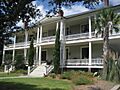
Circa 1900 building on Sullivan's Island, renovated for use as condominiums
-
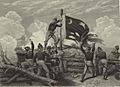
The Moultrie Flag (also known as the Liberty Flag) being raised over Fort Moultrie, after its successful defense against British invaders
-
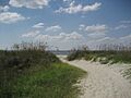
The beach at Sullivan's Island
See also
 In Spanish: Sullivan's Island para niños
