
Isle of Palms, South Carolina facts for kids
Quick facts for kids
Isle of Palms, South Carolina
|
||
|---|---|---|
|
City
|
||

Isle of Palms at sunrise
|
||
|
||

Location of Isle of Palms in South Carolina
|
||
| Country | United States | |
| State | South Carolina | |
| County | Charleston | |
| Incorporated | 1938 (town), 1957 (city) | |
| Area | ||
| • Total | 5.44 sq mi (14.08 km2) | |
| • Land | 4.44 sq mi (11.49 km2) | |
| • Water | 1.00 sq mi (2.59 km2) | |
| Elevation | 11 ft (3 m) | |
| Population
(2020)
|
||
| • Total | 4,347 | |
| • Density | 979.94/sq mi (378.36/km2) | |
| Time zone | UTC−5 (EST) | |
| • Summer (DST) | UTC−4 (EDT) | |
| ZIP code |
29451
|
|
| Area code | 843, 854 | |
| FIPS code | 45-36115 | |
| GNIS feature ID | 1227790 | |

Isle of Palms is a city in Charleston County, South Carolina, United States. In 2020, about 4,347 people lived there. Isle of Palms is a barrier island right on the coast of South Carolina. It's part of the larger Charleston area.
This city is on a narrow strip of land right next to the beach. It's separated from the mainland by a waterway called the Intracoastal Waterway. Many people live here all year, and others come for vacations. You'll find big beach houses, resorts, and tasty local restaurants. Beach volleyball is popular in the summer, and a club called "Windjammer" hosts many tournaments throughout the year.
Contents
Exploring Isle of Palms' Location
Isle of Palms is right on the Atlantic Ocean. It's about 15 miles (24 km) east of Charleston.
The city covers about 5.4 square miles (14.1 square kilometers) in total. Most of this area, about 4.4 square miles (11.5 square kilometers), is land. The rest, about 1 square mile (2.6 square kilometers), is water.
Who Lives in Isle of Palms?

The number of people living in Isle of Palms has changed over the years:
- 1960: 1,186 people
- 1970: 2,657 people
- 1980: 3,421 people
- 1990: 3,680 people
- 2000: 4,583 people
- 2010: 4,133 people
- 2020: 4,347 people
People in 2020
In 2020, there were 4,347 people living in Isle of Palms. There were about 1,799 households and 1,325 families. Most people living here were White (93.97%).
People in 2010
In 2010, there were 4,133 people in the city. Most people (97.65%) were White. About 20.1% of households had children under 18. Many families (62.4%) were married couples living together.
The average age of people in the city was 47 years old. About 17% of the population was under 18. The median income for a household was about $76,170. This means half of the households earned more than this, and half earned less.
A Look Back at Isle of Palms' History

The first people to live on the island were the Sewee tribe.
During the American Civil War, a famous Confederate submarine called the H.L. Hunley left from a spot between Isle of Palms and Sullivan's Island.
In the late 1800s, people started using the island as a vacation spot. Back then, you could only get there by ferry. In 1899, J.S. Lawrence bought the island and gave it its current name, "Isle of Palms." Before that, it was known as "Hunting Island" or "Long Island."
A 50-room hotel was built in 1906. In 1912, James Sottile built a beach pavilion and an amusement park. A trolley line was also built to connect the island to Mount Pleasant on the mainland. In 1929, the Grace Memorial Bridge was built, allowing cars to reach the island.
Big changes happened when J.C. Long bought most of the island. He built affordable homes for World War II veterans. Later, in 1975, a large development called the Wild Dunes Beach and Racquet Club was created.
E. Lee Spence, an expert in underwater archaeology, found many shipwrecks near Isle of Palms in the 1960s. He found Civil War blockade runners like the Rattlesnake and the Georgiana. These discoveries led to a law in South Carolina that helps protect and study shipwrecks.
In 1989, Hurricane Hugo hit the island. Much of it was flooded by the storm. Later, in 2008, the city worked on a project to add sand back to the beach. This helped protect buildings from erosion.
County Parks and Recreation
The Charleston County Park and Recreation Commission (CCPRC) manages many places in Charleston County, including the Isle of Palms County Park. They also run marinas and boat landings, like the Cooper River Marina.
Images for kids
-
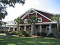
Isle of Palms Recreation Department
-
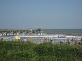
The beach at Isle of Palms
See also
 In Spanish: Isle of Palms para niños
