
James Island, South Carolina facts for kids
Quick facts for kids
Town of James Island
James Island, South Carolina
|
|
|---|---|
|
Town
|
|

The marshes of James Island, SC
|
|
| Country | United States |
| State | South Carolina |
| Counties | Charleston County |
| Incorporated first | January 8, 1993 |
| Incorporated second | 2002 |
| Incorporated third | June 2006 |
| Incorporated fourth | April 24, 2012 |
| Area | |
| • Total | 4.77 sq mi (12.35 km2) |
| • Land | 4.74 sq mi (12.29 km2) |
| • Water | 0.03 sq mi (0.07 km2) |
| Population
(2020)
|
|
| • Total | 11,621 |
| • Density | 2,449.62/sq mi (945.89/km2) |
| Time zone | UTC-5 (Eastern (EST)) |
| • Summer (DST) | UTC-4 (EDT) |
| Zip code |
29412
|
| Area code(s) | 843, 854 |
| FIPS code | 45-36430 |
| Website | http://jamesislandsc.us/ |
James Island is a town located in Charleston County, South Carolina, in the United States. It is found in the central and southern parts of the larger James Island. This town is part of the bigger Charleston-North Charleston-Summerville metropolitan area.
Contents
Exploring James Island's Past
Revolutionary War and Civil War History
James Island has a rich history, especially during important American wars. On November 14, 1782, near the end of the American Revolutionary War, Tadeusz Kościuszko, a Colonel in the Continental Army, led the last known armed action against the British here. He was almost killed in this battle. Later, the Continental Congress recognized his bravery and made him a Brigadier General.
During the American Civil War, a major battle called the Battle of Secessionville was fought on James Island. This shows how important the island was in both conflicts.
Becoming a Town: A Long Journey
For a long time, James Island was a quiet, mostly rural area. But as the nearby city of Charleston grew, the island started to become more urban.
Residents of the island decided they wanted their own town government. So, on January 8, 1993, they officially formed the Town of James Island. Joan Sooy became the first Mayor in March 1993.
However, the City of Charleston challenged this. They argued that parts of the new town were not connected, because salt marshes that Charleston had already taken over separated them. The South Carolina Supreme Court agreed with Charleston in 1997, and the town was closed.

The state legislature then changed the law to allow towns to include areas like salt marshes, even if they were already part of another city. So, James Island tried again and became a town for a second time in 2002. Mary Clark was elected Mayor.
But Charleston challenged the town again, saying the new law was unfair. The South Carolina Supreme Court once more ruled against the town, and it was closed for a second time.
After more changes to state laws in 2005, James Island made a third attempt to become a town in June 2006. About 3,000 people voted for it. The very next day, Charleston's mayor, Joseph P. Riley Jr., filed another lawsuit. Mary Clark was elected mayor for the third time in August 2006.
In November 2008, Charleston lost its lawsuit against the town. In 2010, Bill Woolsey became the new mayor.
Sadly, in June 2011, the South Carolina Supreme Court ruled against the town again. They said the law used was fine, but about 25% of the town's area wasn't connected properly. Instead of just removing that part, they ordered the whole town to close.
Finally, the town was incorporated for a fourth time after a vote on April 24, 2012. This time, the City of Charleston decided not to challenge it, and the deadline for a challenge passed. Former Mayor Bill Woolsey led this effort and was re-elected mayor multiple times.
Historical Sites and Landmarks
James Island is home to many important historical places. McLeod Plantation, a former cotton plantation, is now a park where you can learn about its past. Fort Johnson is believed to be where the first shot of the Civil War was fired. The remains of Fort Lamar are also nearby.
Several places on James Island are listed on the National Register of Historic Places, meaning they are very important to the nation's history. These include:
- Fort Johnson/Powder Magazine
- Fort Pemberton
- Lighthouse Point Shell Ring (38CH12)
- Marshlands Plantation House
- Seashore Farmers' Lodge No. 767
- Unnamed Battery No. 1
Getting Around: Airports Near James Island
James Island is served by the Charleston International Airport. This airport is located in North Charleston, about 12 miles (20 km) northwest of James Island. It is the busiest passenger airport in South Carolina. It shares its runways with the Charleston Air Force Base.
A smaller airport, Charleston Executive Airport, is on John's Island. It is used by private planes and non-commercial aircraft. Both airports are managed by the Charleston County Aviation Authority.
Who Lives on James Island?
| Historical population | |||
|---|---|---|---|
| Census | Pop. | %± | |
| 1870 | 1,808 | — | |
| 2020 | 11,621 | — | |
| U.S. Decennial Census | |||
According to the 2020 United States census, 11,621 people live in the town of James Island. There were 4,706 households and 3,028 families living here.
Famous People from James Island
Many notable people have connections to James Island:
- Stephen Colbert: A famous comedian and television host, he spent part of his childhood on James Island.
- Roddy White: A well-known wide receiver who played for the Atlanta Falcons in American football.
- Samuel Smalls: The real person who inspired the character "Porgy" in the famous novel Porgy and the opera Porgy and Bess. He is buried near James Island Presbyterian Church.
- Tony Elliott (American football coach): A football coach for the University of Virginia who graduated from James Island High School.
- Gorman Thomas: A former center fielder and designated hitter for the Milwaukee Brewers baseball team.
Neighborhoods to Explore
While some older neighborhoods like Riverland Terrace are not officially part of the Town of James Island, many wonderful neighborhoods are. These include White Point Estates, Stiles Point Plantation, Eastwood, Harbor Woods, Seaside Plantation, and Parrot Creek.
-
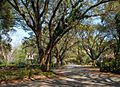
Oak trees over 100 years old line the entrance to Riverland Terrace
-
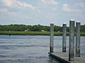
Boat landing in Riverland Terrace
-
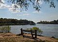
The Wappoo Cut which borders one side of neighborhood
-
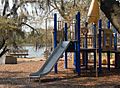
Plymouth Park
-
Recently remodeled Town Hall


See also
 In Spanish: James Island para niños
