Jacksonboro, South Carolina facts for kids
Quick facts for kids
Jacksonboro, South Carolina
|
|
|---|---|
 |
|
| Country | United States |
| State | South Carolina |
| County | Colleton |
| Area | |
| • Total | 14.47 sq mi (37.47 km2) |
| • Land | 14.47 sq mi (37.47 km2) |
| • Water | 0.00 sq mi (0.00 km2) |
| Elevation | 23 ft (7 m) |
| Population
(2020)
|
|
| • Total | 412 |
| • Density | 28.47/sq mi (10.99/km2) |
| Time zone | UTC-5 (Eastern (EST)) |
| • Summer (DST) | UTC-4 (EDT) |
| ZIP code |
29446
|
| Area code(s) | 843 and 854 |
| GNIS feature ID | 1246146 |
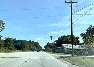
Jacksonboro is a small community in Colleton County, South Carolina, United States. It's not a city with its own government, but it's a recognized area where people live. It sits along the west side of the Edisto River.
Jacksonboro is an important stop along U.S. Highway 17. This highway connects it to bigger cities like Charleston, about 32 miles (51 km) to the east, and Beaufort, about 41 miles (66 km) to the southwest. Walterboro, which is the main town of Colleton County, is about 16 miles (26 km) away.
History of Jacksonboro
Jacksonboro was started way back in the 1730s. It was named after a man named John Jackson, who owned the land where the community began.
Pon Pon Chapel
One important historical building in Jacksonboro is the Pon Pon Chapel. This chapel is so important that it was added to the National Register of Historic Places in 1972. This list includes places that are special because of their history or architecture.
Population Facts
In 2020, about 412 people lived in Jacksonboro. This number helps us understand how many people call this community home.
See also
 In Spanish: Jacksonboro (Carolina del Sur) para niños
 | Shirley Ann Jackson |
 | Garett Morgan |
 | J. Ernest Wilkins Jr. |
 | Elijah McCoy |


