
Beaufort, South Carolina facts for kids
Quick facts for kids
Beaufort, South Carolina
|
||
|---|---|---|

Bay Street, Downtown Beaufort
|
||
|
||

Beaufort, South Carolina
Location in South Carolina

Beaufort, South Carolina
Location in the United States
|
||
| Country | United States | |
| State | South Carolina | |
| County | Beaufort | |
| Incorporated | 1711 | |
| Named for | Henry Somerset, 2nd Duke of Beaufort | |
| Area | ||
| • City | 25.32 sq mi (65.58 km2) | |
| • Land | 24.43 sq mi (63.28 km2) | |
| • Water | 0.89 sq mi (2.29 km2) | |
| Elevation | 10 ft (3 m) | |
| Population
(2020)
|
||
| • City | 13,607 | |
| • Density | 556.89/sq mi (215.01/km2) | |
| • Urban | 52,515 (US: 487th) | |
| • Urban density | 1,200.1/sq mi (463.3/km2) | |
| Time zone | UTC−5 (Eastern (EST)) | |
| • Summer (DST) | UTC−4 (EDT) | |
| ZIP codes |
29901-29907
|
|
| Area codes | 843, 854 | |
| FIPS code | 45-04690 | |
| GNIS feature ID | 1245003 | |

Beaufort (pronounced BEW-fərt) is a city in South Carolina, United States. It is the main city of Beaufort County. The city was started in 1711, making it the second-oldest city in South Carolina, after Charleston. Beaufort is often called the "Queen of the Carolina Sea Islands." In 2020, about 13,607 people lived there. It is part of the larger Hilton Head Island–Bluffton metropolitan area.
Beaufort is located on Port Royal Island, which is part of the Sea Islands and the South Carolina Lowcountry. The city is famous for its beautiful location and its many old, historic buildings. The area played a big role after the U.S. Civil War during the Reconstruction era. This history is remembered at the Reconstruction Era National Monument, which opened in 2017. Beaufort is also known for its military bases. It is close to Parris Island and a U.S. naval hospital. It is also home to the Marine Corps Air Station Beaufort.
Contents
History of Beaufort

The written history of this area began about 500 years ago. Spanish Captain Pedro de Salazar explored the area between 1514 and 1516. This means Beaufort County was one of the first places in North America where Europeans landed.
Before the British arrived, other European explorers tried to settle here but didn't succeed. British colonists finally founded Beaufort in 1711. The city was named after Henry Somerset, 2nd Duke of Beaufort. At first, it grew slowly because of attacks from Native American tribes and threats from the Spanish Empire.
Later, Beaufort became important for building ships. It also became a center for wealthy plantation owners before the American Civil War. During the Civil War, Union forces took over Beaufort after the Battle of Port Royal. Because of this early takeover, many people who had been enslaved came to the city seeking freedom. The Union declared them free and helped them get an education. They also helped them prepare for life as free people.
After the war, the city relied on mining a mineral called phosphate. But a terrible hurricane in 1893 and a fire in 1907 caused a lot of damage. These events slowed the city's growth for almost 50 years.
In the second half of the 1900s, Beaufort became a popular place for tourists. It also grew because more military bases were built nearby, creating many jobs. Local groups have worked hard to protect Beaufort's historic buildings and unique charm. These efforts have made the city famous for its beauty and good quality of life.
In 2022, Beaufort started a friendly connection with Ostroh, Ukraine. People in Beaufort raised money to help Ostroh during the Russian invasion.
Many historic places in Beaufort are listed on the National Register of Historic Places. These include The Anchorage, William Barnwell House, Barnwell-Gough House, Beaufort National Cemetery, John A. Cuthbert House, Fort Lyttelton Site, Hunting Island State Park Lighthouse, Laurel Bay Plantation, Marshlands, Seacoast Packing Company, Seaside Plantation, Robert Smalls House, Tabby Manse, and John Mark Verdier House.
Geography of Beaufort
Beaufort is located at 32°25′55″N 80°41′22″W / 32.43194°N 80.68944°W. Most of the city is on Port Royal Island. It shares this island with Port Royal and other parts of Beaufort County. The city has also grown to include land on Lady's Island, which is across the Beaufort River.
The city is in a marshy area near the water. According to the United States Census Bureau, Beaufort covers about 65.58 square kilometers (25.32 square miles). About 63.28 square kilometers (24.43 square miles) is land, and 2.29 square kilometers (0.89 square miles) is water.
Climate in Beaufort
Beaufort has a humid subtropical climate. This means it has warm winters compared to other parts of South Carolina.
| Climate data for Beaufort, South Carolina (Marine Corps Air Station Beaufort) 1991–2020 normals, extremes 1945–present | |||||||||||||
|---|---|---|---|---|---|---|---|---|---|---|---|---|---|
| Month | Jan | Feb | Mar | Apr | May | Jun | Jul | Aug | Sep | Oct | Nov | Dec | Year |
| Record high °F (°C) | 83 (28) |
87 (31) |
91 (33) |
94 (34) |
103 (39) |
106 (41) |
106 (41) |
103 (39) |
98 (37) |
94 (34) |
88 (31) |
82 (28) |
106 (41) |
| Mean maximum °F (°C) | 76 (24) |
79 (26) |
84 (29) |
88 (31) |
94 (34) |
97 (36) |
98 (37) |
97 (36) |
93 (34) |
87 (31) |
82 (28) |
77 (25) |
100 (38) |
| Mean daily maximum °F (°C) | 60.3 (15.7) |
63.7 (17.6) |
69.9 (21.1) |
77.0 (25.0) |
84.0 (28.9) |
88.9 (31.6) |
91.8 (33.2) |
90.3 (32.4) |
85.7 (29.8) |
78.1 (25.6) |
69.3 (20.7) |
62.7 (17.1) |
76.8 (24.9) |
| Daily mean °F (°C) | 50.2 (10.1) |
53.3 (11.8) |
59.3 (15.2) |
66.5 (19.2) |
74.2 (23.4) |
80.1 (26.7) |
83.2 (28.4) |
82.2 (27.9) |
77.6 (25.3) |
68.6 (20.3) |
58.8 (14.9) |
52.8 (11.6) |
67.2 (19.6) |
| Mean daily minimum °F (°C) | 40.1 (4.5) |
42.8 (6.0) |
48.7 (9.3) |
56.0 (13.3) |
64.3 (17.9) |
71.3 (21.8) |
74.5 (23.6) |
74.1 (23.4) |
69.5 (20.8) |
59.0 (15.0) |
48.4 (9.1) |
42.9 (6.1) |
57.9 (14.4) |
| Mean minimum °F (°C) | 25 (−4) |
28 (−2) |
32 (0) |
42 (6) |
51 (11) |
63 (17) |
69 (21) |
68 (20) |
59 (15) |
44 (7) |
33 (1) |
28 (−2) |
23 (−5) |
| Record low °F (°C) | 5 (−15) |
16 (−9) |
21 (−6) |
32 (0) |
41 (5) |
51 (11) |
62 (17) |
57 (14) |
45 (7) |
31 (−1) |
19 (−7) |
11 (−12) |
5 (−15) |
| Average precipitation inches (mm) | 2.90 (74) |
2.91 (74) |
3.11 (79) |
3.06 (78) |
2.50 (64) |
4.99 (127) |
5.57 (141) |
6.50 (165) |
4.03 (102) |
3.77 (96) |
2.51 (64) |
3.17 (81) |
45.02 (1,144) |
| Average precipitation days (≥ 0.01 in) | 9.2 | 8.9 | 9.2 | 8.5 | 8.4 | 12.5 | 12.6 | 12.9 | 10.1 | 8.2 | 7.8 | 9.6 | 117.9 |
| Source: NOAA | |||||||||||||
Neighborhoods in Beaufort


Beaufort has several distinct neighborhoods.
Historic District
The oldest part of Beaufort is the historic district. It covers about 304 acres (1.23 square kilometers) and is a National Historic Landmark. This area is on a peninsula that goes into the Beaufort River. It includes five smaller historic neighborhoods: Downtown (the main business area), The Point (also called the Old Point), The Bluff, The Old Commons, and the Northwest Quadrant.

Other Residential Areas
As Beaufort grew in the 1900s, new homes were built north and west of the historic district. This growth was largely due to more military families moving to the area. These new areas are now important parts of the city where most residents live.
- Pigeon Point and Higginsonville are just north of downtown. They have the Beaufort National Cemetery and two major city parks. Many homes in Pigeon Point have been renovated recently. Higginsonville has streets named after famous people who worked to end slavery during the Civil War.
- The West End and Depot neighborhoods are west of Ribaut Road. These areas have been updated recently. They used to be centered around the Beaufort train station. Many military families live here.
- Spanish Point is between Downtown and Mossy Oaks. It is near the Technical College of the Lowcountry and Beaufort Memorial Hospital. This area has some fancy residential streets.
- Battery Creek neighborhoods like Mossy Oaks, Royal Oaks, First Boulevard, and Cottage Farms are in the southern part of the city. They have different types of homes, from attached houses to large properties.
- Lady's Island has parts that have been added to Beaufort. Most of these areas have nice homes. Beaufort High School and the Beaufort County Airport are also on Lady's Island.
Other Non-Residential Areas
Areas along Boundary Street (US Highway 21), the Robert Smalls Parkway (SC Highway 170), and Ribaut Road are now Beaufort's main shopping and business areas. You can find many stores, restaurants, and medical offices here.
- Uptown Beaufort is a commercial area along Boundary Street. It connects the historic district with the Pigeon Point neighborhood.
- Beaufort Town Center is a newer area along Boundary Street. It is near the Beaufort County government buildings. Many businesses and offices have moved to this area.
- The Marine Corps Air Station Beaufort was added to the city in the 1990s. It expanded the city limits to the north.
People in Beaufort
| Historical population | |||
|---|---|---|---|
| Census | Pop. | %± | |
| 1850 | 879 | — | |
| 1870 | 1,739 | — | |
| 1880 | 2,549 | 46.6% | |
| 1890 | 3,587 | 40.7% | |
| 1900 | 4,110 | 14.6% | |
| 1910 | 2,486 | −39.5% | |
| 1920 | 2,831 | 13.9% | |
| 1930 | 2,776 | −1.9% | |
| 1940 | 3,185 | 14.7% | |
| 1950 | 5,081 | 59.5% | |
| 1960 | 6,298 | 24.0% | |
| 1970 | 9,434 | 49.8% | |
| 1980 | 8,634 | −8.5% | |
| 1990 | 9,576 | 10.9% | |
| 2000 | 12,789 | 33.6% | |
| 2010 | 12,361 | −3.3% | |
| 2020 | 13,607 | 10.1% | |
| U.S. Decennial Census | |||
Beaufort first appeared in the U.S. Census in 1850.
2020 Census
| Race | Num. | Perc. |
|---|---|---|
| White (non-Hispanic) | 8,845 | 65.0% |
| Black or African American (non-Hispanic) | 2,757 | 20.26% |
| Native American | 26 | 0.19% |
| Asian | 254 | 1.87% |
| Pacific Islander | 25 | 0.18% |
| Other/mixed | 549 | 4.03% |
| Hispanic or Latino | 1,151 | 8.46% |
In 2020, there were 13,607 people living in Beaufort. There were 4,839 households and 3,317 families.
2010 Census
In 2010, 12,361 people lived in the city. The population density was about 447.9 people per square mile. The city's population was mostly White (67.1%) and African American (25.7%). About 6.7% of the population was Hispanic or Latino.
Culture in Beaufort
Media
Beaufort has several local publications. The Beaufort Gazette is the oldest newspaper in South Carolina. The Island News and Lowcountry Weekly are other local newspapers.
Several radio stations broadcast in Beaufort, like WAGP, 88.7 FM, "The Light." Beaufort also has one local TV station, WJWJ-TV (PBS).
Books and Film
Beaufort has been the setting for many novels by local author Pat Conroy. It is also a popular place to film movies. Some famous movies filmed here include The Big Chill, The Prince of Tides, The Great Santini, Forrest Gump, Something To Talk About, and G.I. Jane.
The book Midnight in the Garden of Good and Evil by John Berendt mentions a cemetery in Beaufort. The story features a character based on a real Beaufort resident.
The novel The Book of Negroes (also called Someone Knows My Name) by Lawrence Hill is about the American Revolutionary War. It tells the story of Black Americans who gained freedom by joining the British. Many of them were later resettled in Nova Scotia, Canada.
Tourism and Events

Beaufort is a popular place for tourists because of its history. Major events include the Home Water Festival in July and the Shrimp Festival in October. The Shrimp Festival was even named one of the Southeast Tourism Society's Top 20 Events in 2007.
The Beaufort International Film Festival happens in mid-February. "A Taste of Beaufort" is held in May, featuring local restaurants and live music. Historic home tours also take place in the spring and fall. The city is home to The Kazoo Museum, which opened in 2010. Hunting Island State Park is nearby and is the most visited state park in South Carolina.
The Arts

Beaufort is known as one of "America's Best Art Towns." It has been ranked highly by magazines like American Style Magazine. There are almost 20 art galleries in the city, and many local artists contribute to the art scene.
The University of South Carolina Beaufort has a performing arts center. It brings regional and national shows to the community. The Arts Council of Beaufort supports the arts through ARTworks, a large community arts center. It has a theater, gallery, artist studios, and spaces for workshops and classes.
Sports and Recreation
Beaufort County's Recreation Department offers sports all year round. Kids can play football, basketball, baseball, softball, soccer, and cheerleading. There are many parks with tennis courts, playgrounds, and ballfields.
The area is great for watersports and boating. Field and Stream Magazine named Beaufort one of the top 20 fishing towns in the U.S. in 2008. National Geographic Adventure also called Beaufort a "Top 50 Adventure Town."
Religion
Beaufort has many Christian churches. The Parish Church of St. Helena, founded in 1712, is the oldest church in the city. Other notable churches include Community Bible Church, The Baptist Church of Beaufort, and First African Baptist Church. Beaufort also has a historic Jewish community, with the Beth Israel Congregation synagogue.
Economy in Beaufort

Beaufort is close to fast-growing areas like Hilton Head Island and Bluffton. It also has good access to Savannah, Georgia and its airport and port. This makes Beaufort a good place for homes and businesses.
Beaufort's downtown area is historic and now mostly focuses on tourists. Everyday businesses for locals are found along Boundary Street, Robert Smalls Parkway, and on Lady's Island. There are also some industrial areas in the city's northwest.
The biggest part of Beaufort's economy is the military. The military bases in and around Beaufort provide thousands of jobs. They also bring millions of dollars into the local economy. This helps the community during tough economic times.
Tourism is also a very important part of the economy. Nearly 2 million visitors come to Beaufort and the Sea Islands each year. They come for golf, beaches, history, water sports, and local arts. Beaufort has many places to stay, from bed-and-breakfasts to motels. There are also many restaurants for both locals and tourists.
One of the largest employers is Beaufort Memorial Hospital (BMH). It is a 197-bed hospital and a major medical center between Charleston and Savannah. Other important parts of the economy include farming, local government, and retail.
Education in Beaufort
Schools
Public schools in Beaufort are managed by the Beaufort County School District (BCSD). This district has schools from Pre-Kindergarten through 12th grade. There are also several private schools in the area.
| Elementary schools | Middle schools | High schools | Charter schools | Private schools |
|---|---|---|---|---|
| Beaufort Elementary School | Beaufort Middle School | Battery Creek High School | Riverview Charter School | Agape Christian Academy |
| Broad River Elementary School | Lady's Island Middle School | Beaufort High School | Lowcountry Montessori | Beaufort Academy (Lady's Island) |
| Coosa Elementary School | Robert Smalls Middle School | Whale Branch Early College High School | Bridges Preparatory School | Beaufort Christian School |
| Joseph Shanklin Elementary School | Whale Branch Middle School | Beaufort-Jasper Academy for Career Excellence | St. Peter's Catholic School | |
| Lady's Island Elementary School | Eleanor Christensen Montessori School | |||
| Port Royal Elementary School | Holy Trinity Classical Christian School | |||
| Mossy Oaks | ||||
| Whale Branch Elementary School |
The Beaufort Marine Corps Air Station has its own schools for younger students. These schools are for children of military and government employees living on the base. High school students from the base attend Battery Creek High School.
Higher Education
Beaufort has a few places for higher education. The University of South Carolina Beaufort North Campus and the Technical College of the Lowcountry Main Campus are both in the city. Clemson University also has an office in Beaufort for environmental and farming programs.
Libraries and Museums
The Beaufort area has almost 70 places listed on the National Register of Historic Places. The John Mark Verdier House is the only historic home open to the public all year.
The Beaufort County Library serves residents of Beaufort and northern Beaufort County. The University of South Carolina Beaufort also has a library.
Transportation in Beaufort
Major Roads
Important roads in Beaufort help people get around.
 US 21 is a main road that connects the city to the Sea Islands. It is also the main route for leaving the area during a hurricane.
US 21 Bus. is the main road through downtown Beaufort. It goes along Boundary Street and Carteret Street. SC 116 (Laurel Bay Road) connects the Marine Corps Air Station Beaufort to military housing.
 SC 170 (Robert T. Smalls Parkway) connects Beaufort to southern Beaufort County and Savannah, Georgia.
 SC 281 (Ribaut Road) connects Beaufort and Port Royal.
 SC 802 (Sams Point Road) connects Lady's Island to US 21.
Other important roads nearby include ![]() US 17, which connects Beaufort to Charleston and other towns. Interstate 95 is about 25 miles (40 km) away.
US 17, which connects Beaufort to Charleston and other towns. Interstate 95 is about 25 miles (40 km) away.
Other Transportation

- Palmetto Breeze provides local public transportation.
- The Downtown Marina is a gateway for boats on the Intracoastal Waterway. There are also other marinas and boat landings nearby.
- Greyhound has a bus station in Beaufort, connecting the city to a national bus network.
- Beaufort County Airport is for smaller planes. For commercial flights, the closest airports are in Hilton Head Island, Charleston, and Savannah.
- The Port Royal Railroad used to serve Beaufort for freight and passengers. The tracks were removed in 2011 to create the Spanish Moss Trail, a walking and biking path.
Utilities
Water and sewer services are provided by the Beaufort-Jasper Water and Sewer Authority. Trash and recycling are handled by Waste Pro. Dominion Energy provides electricity. Charter, Hargray, and CenturyLink offer phone, internet, and cable TV services.
Famous People from Beaufort
Actors, Authors, and Entertainers
- Samuel Hopkins Adams, author
- Tom Berenger, actor
- Pat Conroy, author of many novels about the area
- Esther Dale, film actress
- Cool John Ferguson, blues guitarist and singer
- Candice Glover, winner of American Idol Season 12
- Jazzy Jay, hip-hop disc jockey
- Maude Odell, stage actress
- Terry Sweeney, actor
- Mary Scrimzeour Whitaker, author
Athletes
- Brendan Allen, mixed martial artist
- Kevin Brooks, basketball player
- C.J. Cummings, weightlifter
- Dee Delaney, football player
- Lacey Evans, former professional wrestler
- Joe Frazier, heavyweight boxing champion, first person to beat Muhammad Ali
- Greg Jones, football player
- Ashley Lelie, football player
- Ron Parker, football player
- Naya Tapper, rugby player, Olympic Bronze Medalist
- Devin Taylor, football player
Politicians and Leaders
- Robert Barnwell, former U.S. congressman
- Robert Woodward Barnwell, former U.S. and Confederate congressman
- Edward Junius Black, former U.S. congressman
- Alvin Brown, first African American mayor of Jacksonville, Florida
- William F. Colcock, former U.S. congressman
- Charles Craven, former governor and founder of Beaufort
- William Elliot, former U.S. congressman
- John Floyd, former U.S. congressman
- Richard Howell Gleaves, former Lieutenant Governor of South Carolina
- William J. Grayson, former U.S. congressman and poet
- W. Brantley Harvey Jr., state legislator and lawyer
- W. Brantley Harvey Sr., state legislator and lawyer
- Francis Lubbock, former governor of Texas
- Michael P. O'Connor, former U.S. congressman
- Libby Pataki, wife of former Governor of New York George Pataki
- Clementa C. Pinckney, state senator and pastor
- Robert Rhett, former U.S. congressman
- Robert Smalls, former slave and Civil War hero, later a U.S. Congressman
- William Verity, Jr., former U.S. Secretary of Commerce
Others
- Robert W. Barnwell, former Episcopal bishop
- Richard W. Colcock, former president of The Citadel
- Donald Conroy, former USMC colonel, father of Pat Conroy
- Patricia Denkler, record-setting woman aviator
- Stephen Elliott, former Episcopal bishop
- John Edwards Holbrook, former zoologist
- Leon Keyserling, economist and adviser to President Truman
- Anita Pollitzer, former photographer
- Anne Pressly, former news anchor
Images for kids
-
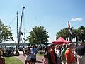
The Beaufort Shrimp Festival is one of several popular annual events in the Henry Chambers Waterfront Park.
-
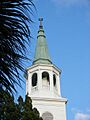
The steeple of the Parish Church of St. Helena.
-
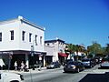
Downtown businesses clustered along Bay Street, adjacent to the Henry Chambers Waterfront Park.
See also
 In Spanish: Beaufort (Carolina del Sur) para niños
