
Beaufort Historic District (Beaufort, South Carolina) facts for kids
|
Beaufort Historic District
|
|
.jpg)
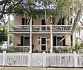
Saltus-Habersham House, 802 Bay Street
|
|

Location in South Carolina

Location in the United States
|
|
| Location | Bounded by the Beaufort River, Bladen, Hamar, and Boundary Sts., Beaufort, South Carolina |
|---|---|
| Area | 304 acres (123 ha) |
| Built | 1521 |
| Architectural style | Federal, Greek Revival |
| NRHP reference No. | 69000159 |
Quick facts for kids Significant dates |
|
| Added to NRHP | December 17, 1969 |
| Designated NHLD | November 7, 1973 |
The Beaufort Historic District is a special area in Beaufort, South Carolina, known for its old and beautiful buildings. It became a part of the National Register of Historic Places in 1969. Later, in 1973, it was named a National Historic Landmark, which means it's super important to the history of the United States.
This historic area is famous for its many buildings built before the American Civil War. These buildings show off styles like Federal, Neoclassical, and Greek Revival. You'll also see lots of "tabby" used, which is a unique building material made from oyster shells.
The district has all sorts of historic places, like homes, gardens, shops, churches, and old graveyards. Some of these spots are even open for you to visit! People in Beaufort work hard to keep these historic buildings safe and looking good. This effort has made the district very popular with visitors and the media.
Over the years, experts have checked on the district's condition. In 1998, there was a concern that some of its historic charm was slowly being lost. Because of this, people decided to also highlight a special part of Beaufort's history after the Civil War. This was called the Port Royal Experiment. It was a big effort to help formerly enslaved African Americans by giving them land. This project changed Beaufort a lot and you can still see its impact in the buildings today.
Contents
Exploring Beaufort's Historic Neighborhoods
The Beaufort Historic District is made up of five unique neighborhoods. Each one has its own special feel and history.
Downtown: The Heart of Beaufort
Downtown Beaufort is centered around Bay Street, which has always been the main shopping area. It's mostly filled with businesses. Right by the Beaufort River and Bay Street, you'll find the Henry Chambers Waterfront Park. This park is a great place to relax and watch the river. Many of the city's fun festivals and events happen here. Today, downtown is mostly home to restaurants and shops selling art, crafts, and antiques.
The Point: Grand Homes and Live Oaks
The Point neighborhood, also called the Old Point, has some of Beaufort's biggest, oldest, and most expensive homes. It's located between Carteret Street and the Beaufort River. This area used to be a timber mill. The homes here range from huge mansions overlooking the river to beautiful Victorian and Queen Anne style houses along Craven Street. The streets are often covered by a canopy of huge live oak trees, draped with Spanish moss, which looks really cool.

The Bluff: Scenic Views and Iconic Buildings
The Bluff area is found along Bay Street and North Street, just west of downtown. The large homes here are very famous and offer amazing views of the Beaufort River. At the western end of The Bluff, you'll find the U.S. District Courthouse, which has a cool Art Deco design.
The Old Commons: Historic Charm and Porches
The Old Commons neighborhood, also known as the Northeast Quadrant, is in the northeastern part of Beaufort's original street layout. It's bordered by Carteret Street, North Street, Charles Street, and Boundary Street. This area used to have a mix of medium-sized homes, graveyards, and chapels. It's now being updated, but it still keeps its classic Southern style. Almost all the homes in this neighborhood have front or side porches, perfect for relaxing.
The Northwest Quadrant: A Community's History
The Northwest Quadrant neighborhood is generally located between Charles Street, Prince Street, Ribaut Road, and Boundary Street. For many years, this area has been the center of Beaufort's African-American community. It features homes built in the late 1800s and early 1900s, many in the unique shotgun style. Bladen Street is the main street here and has recently been improved with new landscaping and better sidewalks for walking. There are growing efforts to fix up many properties in this area, even though it can be challenging.
Important Historic Sites in Beaufort
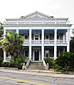
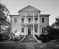
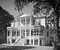
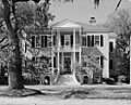
Several individual buildings in Beaufort are so important that they are listed on the National Register of Historic Places on their own. Many of these are also part of the larger Historic District. Here are some of them:
- The Anchorage
- William Barnwell House
- Barnwell-Gough House
- John A. Cuthbert House
- Marshlands (a National Historic Landmark)
- Robert Smalls House (a National Historic Landmark)
- Tabby Manse
- John Mark Verdier House
- The Cobbler's Cottage
Images for kids
-
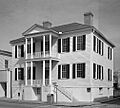
The Anchorage
-
Barnwell-Gough House
-
John A. Cuthbert House
-
Tabby Manse
-
John Mark Verdier House
-
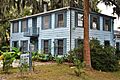
710 Prince Street
-
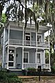
Barnwell House, 705 Prince Street
-
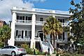
George Parsons Elliott House
-
The Cobbler's Cottage

.jpg)
.jpg)
.jpg)
.jpg)
.jpg)
.jpg)


