Beaufort County, South Carolina facts for kids
Quick facts for kids
Beaufort County
|
|||
|---|---|---|---|

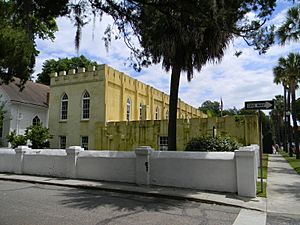
The Arsenal in Beaufort Historic District
|
|||
|
|||
| Motto(s):
"Heritage By The Sea"
|
|||

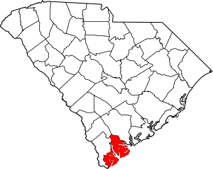
Location within the U.S. state of South Carolina
|
|||
 South Carolina's location within the U.S. |
|||
| Country | |||
| State | |||
| Founded | 1800 | ||
| Named for | Henry Somerset, 2nd Duke of Beaufort | ||
| Seat | Beaufort | ||
| Largest community | Hilton Head Island | ||
| Area | |||
| • Total | 923.48 sq mi (2,391.8 km2) | ||
| • Land | 576.04 sq mi (1,491.9 km2) | ||
| • Water | 347.44 sq mi (899.9 km2) 37.62% | ||
| Population
(2020)
|
|||
| • Total | 187,117 | ||
| • Estimate
(2023)
|
198,979 | ||
| • Density | 324.83/sq mi (125.42/km2) | ||
| Time zone | UTC−5 (Eastern) | ||
| • Summer (DST) | UTC−4 (EDT) | ||
| Congressional district | 1st | ||
Beaufort County is a county located in the state of South Carolina. In 2020, about 187,117 people lived here. The main town where the county government is located is Beaufort. The biggest community in the county is Hilton Head Island.
Beaufort County is part of a larger area called the Hilton Head Island-Bluffton-Port Royal, SC Metropolitan Statistical Area. It is one of the fastest-growing counties in the southern United States. This growth is mostly happening south of the Broad River. The northern parts of the county are also growing steadily. This is partly because of the strong presence of the U.S. military near the city of Beaufort. The two parts of the county are connected by the Broad River Bridge.
Contents
History of Beaufort County
Beaufort County has a very rich history. For a long time, many African slaves lived and worked on plantations here. These plantations were mostly on the Sea Islands. Slaves on these islands often had limited contact with white people. This led to the development of the unique Gullah culture and the Gullah language. This language is a mix of different West African languages. The county had more Black residents than white residents until the mid-1900s.
The Civil War and Freedom
During the American Civil War, Union troops took control of Beaufort County in 1861. Many enslaved people escaped to the Union lines. Some plantation owners left their slaves on the Sea Islands when they moved inland for safety.
Early in the war, formerly enslaved people in this county started to organize their own schools and communities. For example, the Army created a village called Mitchellville on Hilton Head in 1863. This village allowed Black people to govern themselves. By 1865, about 1,500 people lived there.
After the Civil War
After the Civil War, formerly enslaved people became citizens. They were also given the right to vote. Most of them joined the Republican Party. South Carolina was the only southern state where Black representatives made up most of the state legislature during the time known as Reconstruction. Beaufort County had many important Black leaders, like Robert Smalls and Jonathan Jasper Wright.
However, white groups used violence and unfair practices to stop Black people from voting. By 1876, Democrats took back control of the state government. In 1895, a new state constitution was passed. This constitution made it very hard for most Black citizens to vote. Even though many Black men in Beaufort County could read, they were not allowed to vote. This kept them from having equal rights for many decades.
Changes in the 20th Century
From 1900 to 1950, farming in Beaufort County became less profitable. This, along with unfair social conditions, caused many African Americans to move away. This movement is known as the Great Migration. They moved to cities in the North and Midwest to find jobs. The county's population dropped a lot during this time.
Later in the 20th century, the U.S. government built military bases in the county. This brought more people and jobs. Also, vacation resorts and tourist areas were developed. These attractions brought many visitors and new residents, especially retirees, which helped the county grow again.
Geography of Beaufort County
Beaufort County covers about 923 square miles. About 576 square miles of this is land, and the rest is water.
Protected Natural Areas
Beaufort County is home to several important natural areas:
- Ashepoo-Combahee-Edisto (ACE) Basin National Estuarine Research Reserve (part)
- Ernest F. Hollings ACE Basin National Wildlife Refuge (part)
- Pinckney Island National Wildlife Refuge
- Reconstruction Era National Historical Park
State and Local Sites
The county also has many state and local protected areas and historic sites:
- Auldbrass Plantation
- Altamaha Towne Heritage Preserve
- Bay Point Shoal Seabird Sanctuary
- Charlesfort - Santa Elena Historic Site
- Coffin Point Plantation
- Coligny Beach Park
- Daws Island Heritage Preserve
- Fort Frederick Heritage Preserve
- Greens Shell Enclosure Heritage Preserve
- Hunting Island State Park
- Joiner Bank Seabird Sanctuary
- Old Island Heritage Preserve/Wildlife Management Area
- Old Sheldon Church Ruins
- Sea Pines Forest Preserve
- South Bluff Heritage Preserve
- Spanish Moss Trail
- Stoney Creek Battery Heritage Preserve
- Stony Creek Bridge
- Victoria Bluff Heritage Preserve/Wildlife Management Area
- Widgeon Point Preserve
Major Water Bodies
Many rivers and the ocean are important parts of Beaufort County:
- Atlantic Ocean (North Atlantic Ocean)
- Colleton River
- Edisto River
- Harbor River
- Intracoastal Waterway
- May River
- Salkehatchie River
Neighboring Counties
Beaufort County shares borders with these counties:
- Colleton County – to the north
- Jasper County – to the west
- Hampton County – to the northwest
Main Roads and Transportation
Important roads and transportation hubs in the county include:
 US 17
US 17
 US 17 Alt.
 US 21
US 21
 US 21 Bus.
 US 278


 US 278 Bus.
 SC 46
SC 46 SC 116
 SC 128
 SC 170
 SC 802
- Hilton Head Island Airport
- Marine Corps Air Station Beaufort
- Marine Corps Recruit Depot Parris Island
People of Beaufort County (Demographics)
| Historical population | |||
|---|---|---|---|
| Census | Pop. | %± | |
| 1790 | 18,753 | — | |
| 1800 | 20,428 | 8.9% | |
| 1810 | 25,887 | 26.7% | |
| 1820 | 32,199 | 24.4% | |
| 1830 | 37,032 | 15.0% | |
| 1840 | 35,794 | −3.3% | |
| 1850 | 38,805 | 8.4% | |
| 1860 | 40,053 | 3.2% | |
| 1870 | 34,359 | −14.2% | |
| 1880 | 30,176 | −12.2% | |
| 1890 | 34,119 | 13.1% | |
| 1900 | 35,495 | 4.0% | |
| 1910 | 30,355 | −14.5% | |
| 1920 | 22,269 | −26.6% | |
| 1930 | 21,815 | −2.0% | |
| 1940 | 22,037 | 1.0% | |
| 1950 | 26,993 | 22.5% | |
| 1960 | 44,187 | 63.7% | |
| 1970 | 51,136 | 15.7% | |
| 1980 | 65,364 | 27.8% | |
| 1990 | 86,425 | 32.2% | |
| 2000 | 120,937 | 39.9% | |
| 2010 | 162,233 | 34.1% | |
| 2020 | 187,117 | 15.3% | |
| 2023 (est.) | 198,979 | 22.7% | |
| U.S. Decennial Census 1790–1960 1900–1990 1990–2000 2010 2020 |
|||
2020 Census Information
In 2020, there were 187,117 people living in Beaufort County. There were about 73,043 households, which are groups of people living together.
| Race | Num. | Perc. |
|---|---|---|
| White (non-Hispanic) | 126,704 | 67.71% |
| Black or African American (non-Hispanic) | 27,545 | 14.72% |
| Native American | 354 | 0.19% |
| Asian | 2,381 | 1.27% |
| Pacific Islander | 119 | 0.06% |
| Other/Mixed | 6,603 | 3.53% |
| Hispanic or Latino | 23,411 | 12.51% |
2010 Census Information
In 2010, the county had 162,233 people. The population was mostly white (71.9%), with a significant Black or African American population (19.3%). About 12.1% of the people were of Hispanic or Latino origin. The average age of people in the county was about 40.6 years old.
Economy of Beaufort County
In 2022, the total value of all goods and services produced in Beaufort County was about $10.8 billion. This means the county's economy is quite strong. The unemployment rate has been low, usually between 2.2% and 3.7%.
Major Employers
Some of the biggest employers in Beaufort County include:
- Beaufort County School District (schools)
- Food Lion (grocery store)
- Kroger (grocery store)
- Marriott (hotels)
- Publix (grocery store)
- United States Department of Defense (military)
- Walmart (retail store)
Many people in Beaufort County work in hotels and restaurants (Accommodation and Food Services), retail stores, and healthcare. Other important jobs are in construction, education, and professional services.
Education in Beaufort County
Beaufort County offers many educational opportunities, from colleges to K-12 schools.
Colleges and Universities
- University of South Carolina Beaufort
Community and Technical Colleges
- Technical College of the Lowcountry
K-12 Schools
Most students in Beaufort County attend schools in the Beaufort County School District. However, children of military families living at the Beaufort Marine Corps Air Station attend special elementary and middle schools run by the Department of Defense Education Activity (DoDEA). These students then go to the county high schools.
Public High Schools
- Battery Creek High School
- Beaufort High School
- Beaufort Jasper Academy for Career Excellence
- Bluffton High School
- Hilton Head Island High School
- May River High School
- Whale Branch Early College High School
Charter Schools
- Bridges Preparatory School
Private Schools
- John Paul II Catholic School
- Hilton Head Christian Academy
- Beaufort Academy
Communities in Beaufort County
Beaufort County is part of the Hilton Head Island-Bluffton-Port Royal, SC Metropolitan Statistical Area. This area had an estimated population of over 232,000 people in 2023.
Cities
- Beaufort (the county seat)
Towns
- Bluffton
- Hilton Head Island (the largest community)
- Port Royal
- Yemassee (partly in Hampton County)
- Hardeeville (mostly in Jasper County)
Census-Designated Places (CDPs)
These are areas that are like towns but are not officially incorporated as cities or towns.
Unincorporated Communities
These are smaller communities that are not officially part of any city or town.
- Brighton Beach
- Dale
- Frogmore
- Lady's Island
- Lobeco
- Parris Island
- Pocotaligo
- Pritchardville
- Sheldon
- Sun City
- Seabrook
Named Islands
Beaufort County has many islands, some of which are also towns.
- Barataria Island
- Bull Island
- Callawassie Island
- Cane Island
- Coosaw Island
- Dataw Island
- Daufuskie Island
- Fripp Island
- Grays Hill
- Harbor Island
- Hilton Head Island
- Hunting Island
- Lady's Island
- Lemon Island
- Little Capers Island (uninhabited)
- Morgan Island
- Parris Island
- Poppy Hill
- Port Royal Island
- Pritchard Island (uninhabited research station)
- Saint Helena Island
- Spring Island
- St. Phillips Island
- Warsaw Island
Notable People from Beaufort County
Many interesting people have come from Beaufort County:
- Pat Conroy, a famous author
- Clarence Cummings, a weightlifter
- Joe Frazier, a legendary boxer
- Candice Glover, winner of American Idol Season 12
- Bob Inglis, a politician
- Greg Jones, a football player
- Thomas E. Miller, an educator, lawyer, and politician
- James Saxon, a football player
- Duncan Sheik, a musician
- Wayne Simmons, a football player
- Robert Smalls, an important politician and former slave
- Stan Smith, a tennis player
- Devin Taylor, a football player
- D.J. Trahan, a golfer
- Kathryn R. Wall, an author
See also
 In Spanish: Condado de Beaufort (Carolina del Sur) para niños
 | Misty Copeland |
 | Raven Wilkinson |
 | Debra Austin |
 | Aesha Ash |


