Saint Helena Island (South Carolina) facts for kids
|
Nickname: Frogmore
|
|
|---|---|

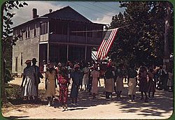
A Fourth of July celebration. St. Helena Island, South Carolina, 1939
|
|
| Geography | |
| Location | Beaufort County, South Carolina, United States |
| Coordinates | 32°22′35″N 80°34′20″W / 32.376272°N 80.572228°W |
| Archipelago | Sea Islands |
| Area | 63.789 sq mi (165.21 km2) |
| Administration | |
|
United States
|
|
| State | South Carolina |
| County | Beaufort |
| Demographics | |
| Population | 8,407 (2000) |
| Pop. density | 50.87 /km2 (131.75 /sq mi) |
| Ethnic groups | Gullah |
St. Helena Island is a special Sea Island located in Beaufort County, South Carolina, United States. It's connected to the town of Beaufort by U.S. Highway 21. The island is about 64 square miles (166 square kilometers) in size. In 2010, about 8,763 people lived there.
St. Helena Island is famous for its rural, natural feel. It's also a very important place for Gullah culture and language. The Gullah people are descendants of West Africans who were brought to the Sea Islands. This island even inspired the children's TV show Gullah Gullah Island.
Contents
Island History: Exploring the Past
Early Explorers and Settlements
The first European to explore St. Helena Island was probably Spanish explorer Lucas Vázquez de Ayllón around 1520. This was part of Spain's efforts to explore and settle the Sea Islands. Later, the French built a fort called Charlesfort on nearby Parris Island. The Spanish then took over the same spot and founded Santa Elena. This became the capital of the entire Spanish colony of La Florida. Eventually, the English took control of the area and held it until the American Revolution. During the War of 1812, the British navy was present around Saint Helena.
The Rise of Gullah Culture
The land on St. Helena Island was very similar to the rice-growing areas of West Africa. Because of this, many enslaved people were brought to the Sea Islands from places like Sierra Leone. These enslaved people, along with Native Americans and indentured servants from Europe, grew crops like rice, indigo, cotton, and spices. This mix of cultures, somewhat separated from the mainland, led to the unique Gullah culture and language.
The Civil War and Freedom
The Civil War began on April 12, 1861, when South Carolina attacked Fort Sumter. On November 7, 1861, the Union army won an important victory at the Battle of Port Royal. President Lincoln wanted to block the ports of the Confederate states. Port Royal was a very important port. Union ships, led by Samuel F. Du Pont, attacked the forts defending Beaufort. After several hours, the islands were captured by the Union and stayed under their control throughout the war.
When the enslaved people were freed, steps were taken to help them. One major step was starting the Penn School to educate them. Another idea was to give land to families. This led to the belief among the freed people that they would receive "forty acres (16 hectares) and a mule" after the Emancipation Proclamation.
The famous Negro spiritual song "Michael Row the Boat Ashore" first came from Saint Helena Island in the 1860s. A photographer named Leigh Richmond Miner took many pictures of the island. A book of his photographs was published in 1970.
Challenges and Preservation
St. Helena Island was severely hit by the Sea Islands Hurricane in 1893. Hundreds of people on the island died. The economic damage from the hurricane lasted for many decades. This made St. Helena Island one of the poorest places in the United States for a long time.
In the late 1900s, the economy in Beaufort improved. New resorts were built on nearby Fripp Island, Harbor Island, and Dataw Island. This started to bring better economic chances to St. Helena Island. However, it also brought pressure for new buildings and developments. These new projects threatened the island's rural character. To stop this, careful planning led to strict rules about development. These rules help make sure the island keeps its rural feel and protects its history and culture. For example, large apartment complexes and gated communities are not allowed on St. Helena Island. Some rural land has been protected through special agreements called conservation easements. Much of the island is still owned by African-Americans, often through traditional family arrangements called heirs property.
The Indian Hill Site and Knights of Wise Men Lodge are important historical places. They are listed on the National Register of Historic Places.
Island Geography: Exploring the Land
St. Helena Island is considered an "inland" Sea Island. This means it doesn't directly face the Atlantic Ocean. The island is surrounded by large marsh areas, especially on its southeastern side. It is the biggest Sea Island in the Beaufort area. It's also the largest island between Edisto Island and Hilton Head Island along the South Carolina coast. The island is unofficially divided into several smaller communities. Each community has its own unique feel. The two most well-known communities are Frogmore and Lands End.
Frogmore Community
Frogmore is seen as the main business area of the island. It's located in the north-central part of the island. For many years, Frogmore was the official name for all of St. Helena Island by the U.S. Postal Service. Many people on the island still call it Frogmore. However, its official name for the U.S. Postal Service is now Saint (St.) Helena, Island, S.C.
Lands End Community
Lands End (sometimes called Fort Fremont) is a small community at the very southern tip of the island. It's home to Fort Fremont, which was once a military fort. This fort helped protect the entrance to the Beaufort River. Lands End is popular because it has easy access to open water. This makes it a great spot for fishing and other fun water activities.
Other Island Areas
Other communities on the island are usually named after the road, point, or smaller island where they are located. Some examples include Dulamo Road, Cedar Grove, Eddings Point, Coffin Point, Fripp Point, Folly Road, Warsaw Island, and Pollawana Road. Three main roads help people travel around most of the island: Sea Islands Parkway (which is U.S. Highway 21), Seaside Road, and Lands End Road.
Education on St. Helena Island
St. Helena Island has a public library. It is a branch of the Beaufort County Library system.
The island's schools are part of the Beaufort County School District. St. Helena Elementary School is the only public school located directly on St. Helena. Older students who live on the island attend Lady's Island Middle School and Beaufort High School.
Notable People from St. Helena Island
Many interesting people have connections to St. Helena Island:
- Sam Doyle, a talented folk artist
- Candice Glover, a singer who won American Idol season 12
- Marquetta Goodwine, also known as Queen Quet, the Chieftess of the Gullah/Geechee Nation
- Leon Keyserling, an economist and lawyer who led the Council of Economic Advisers
- Ron Parker, a safety who played for the Kansas City Chiefs football team
- Michael F. Rivers Sr., a House Representative
- Stephen Robinson, a traditional "root doctor"
- Devin Taylor, a defensive end who played for the Detroit Lions football team
See also
 In Spanish: Saint Helena Island (Carolina del Sur) para niños
 | Madam C. J. Walker |
 | Janet Emerson Bashen |
 | Annie Turnbo Malone |
 | Maggie L. Walker |


