Lady's Island (South Carolina) facts for kids
Quick facts for kids
Lady's Island
|
|
|---|---|

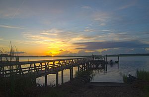
Pier on Lady's Island, July 2013
|
|
| Nickname(s):
Ladies Island
|
|

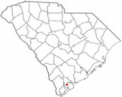
Location of Lady's Island, Beaufort, South Carolina
|
|
| Country | United States |
| State | South Carolina |
| County | Beaufort |
| Elevation | 17 ft (5 m) |
| Population
(2010)
|
|
| • Total | 12,570 |
| Time zone | UTC-5 (Eastern (EST)) |
| • Summer (DST) | UTC-4 (EDT) |
| ZIP codes |
29907
|
| Area code(s) | 843, 854 |
Lady's Island is a beautiful Sea Island located in Beaufort County, South Carolina. Most of the island is a place where people live. While some parts are within the city of Beaufort, much of the island is not part of a city. South Carolina Highway 802, also called Sams Point Road, is the main road on Lady's Island. It's also the only way to reach Coosaw Island.
Contents
Exploring Lady's Island History
Lady's Island has a long and interesting past. Let's discover some key moments in its history.
Early Native American Life
Long ago, the Coosaw people, a group of Native Americans, lived on Lady's Island. They made their homes on the higher ground of Coosaw Point. You can still find pieces of their pottery and oyster shells there. These show how they prepared oysters they gathered from the Coosaw River.
How Lady's Island Got Its Name
Lady's Island was named in 1698. It was named to honor Lady Elizabeth Axtell Blake. She was the wife of Joseph Blake, who was the governor of colonial South Carolina at that time. Lady Elizabeth and her mother, Lady Rebecca Axtell, owned a large farm called Newington Plantation. This farm was located in what is now Summerville, South Carolina. The island is sometimes called by other names too, like Combachee or Combee Island. These names come from the ACE Basin river that flows nearby.
Lady's Island During the Civil War
During the American Civil War, soldiers from the Union army came to Lady's Island. General T. W. Sherman led these forces. All the large farms on the island were taken over by the military. A major military base on Lady's Island was "Coosaw" or "Sams' fort." This fort was located on the northeastern tip of the island. At that time, there were about 30 large farms on Lady's Island.
Growth and Development
For many years, Lady's Island was mostly a rural area with farms. In 1927, the first bridge was built. This bridge connected downtown Beaufort with Lady's Island, making travel much easier. As the areas around Beaufort grew in the late 1900s, Lady's Island also began to change. Former farms and timber lands were turned into neighborhoods for homes. Later, in the 1980s, a second bridge was built. This bridge connected Lady's Island to Port Royal.
Life and Economy on Lady's Island
Lady's Island is a busy place with schools, businesses, and places of worship.
Schools and Education
The island is home to several schools. There are four public schools: two for elementary students, one for middle schoolers, and one high school. There are also private schools like Beaufort Academy, which teaches students from kindergarten through 12th grade. Saint Peter's Catholic School is another private school for younger children.
Shopping and Services
Most of the shops and businesses are located where S.C. Highway 802 and U.S. Highway 21 meet. These businesses serve the people of Lady's Island, Beaufort, and the nearby Sea Islands in northern Beaufort County. The Beaufort County Airport is also located on the island.
Places of Worship
Lady's Island has many different churches and faith communities. These include:
- First Scots Presbyterian Church of Beaufort
- St. John's Lutheran Church
- Sea Island Presbyterian Church
- St. Peter's Catholic Church
- Meadowbrook Baptist Church
- Unitarian Universalist Fellowship of Beaufort
- Israelite Baptist Church
- Grace Chapel AME Church
- Lady's Island Baptist Church
- Water's Edge New United Methodist Church
- Tidal Creek Fellowship
Understanding Lady's Island Ecosystems
Lady's Island is home to three main types of natural environments, called ecosystems. Each ecosystem has its own unique features and living things.
Maritime Ecosystems
The maritime ecosystem includes the upland forest areas on the island. These are the parts of the island that are higher up and covered with trees. This ecosystem is influenced by its closeness to the ocean.
Estuarine Ecosystems
The estuarine ecosystem includes the deep water tidal habitats. An estuary is where fresh water from rivers mixes with salt water from the ocean. These areas are often rich in marine life.
Palustrine Ecosystems
The palustrine ecosystem refers to the fresh water wetlands. A palustrine wetland is a type of marsh or swamp that is not directly connected to the ocean. These areas are important for many plants and animals that need fresh water.
Notable People Connected to Lady's Island
- Lady Elizabeth Axtell Blake: Lady's Island was named in her honor in 1698.
- Joseph Blake: He was the governor of colonial South Carolina and Lady Elizabeth Axtell Blake's husband.
 | Precious Adams |
 | Lauren Anderson |
 | Janet Collins |

