Screven County, Georgia facts for kids
Quick facts for kids
Screven County
|
|
|---|---|

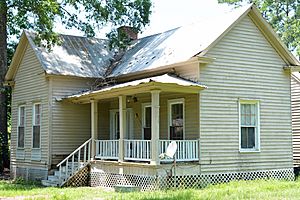
Harris-Murrow-Trowell House in Oliver.
|
|

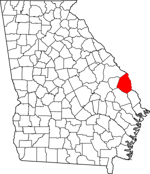
Location within the U.S. state of Georgia
|
|
 Georgia's location within the U.S. |
|
| Country | |
| State | |
| Founded | December 14, 1793 |
| Named for | James Screven |
| Seat | Sylvania |
| Largest city | Sylvania |
| Area | |
| • Total | 656 sq mi (1,700 km2) |
| • Land | 645 sq mi (1,670 km2) |
| • Water | 11 sq mi (30 km2) 1.6%% |
| Population
(2020)
|
|
| • Total | 14,067 |
| Time zone | UTC−5 (Eastern) |
| • Summer (DST) | UTC−4 (EDT) |
| Congressional district | 12th |
Screven County is a special area called a county in the southeastern part of Georgia. It's like a district within the state. In 2020, about 14,067 people lived here. The main town and center of the county is Sylvania.
Contents
History of Screven County
Screven County was created a long time ago, on December 14, 1793. It was named after a brave soldier, General James Screven. He was a general who fought and died in Georgia during the American Revolutionary War.
Sometimes, in old records, the county's name was spelled "Scriven." This was because the general's name was sometimes spelled that way too.
The main town of the county, called the county seat, moved to Sylvania in 1847. Before that, it was in a place called Jacksonborough. The building where the county's government works, the Screven County Courthouse, was built in 1964. It's the fourth courthouse the county has had.
Geography and Nature
Screven County covers a total area of about 656 square miles. Most of this area, about 645 square miles, is land. The rest, about 11 square miles, is water.
The Savannah River forms the eastern border of the county. The Ogeechee River runs along the southwestern part. The land in the county changes from about 40 feet high near the Savannah River to 320 feet high in the Bay Branch area. This area is a few miles west of Sylvania.
You can find many types of trees here. These include pine, oak, and dogwood trees. These trees are common in the southern United States.
Rivers and Waterways
Different parts of Screven County are connected to different river systems. The very northern part of the county is in the Middle Savannah River area. This area is part of the larger Savannah River basin.
A central part of the county, around Hiltonia and north of Sylvania, is in the Brier Creek area. This is also part of the Savannah River basin.
The southern part of the county, from Newington through Sylvania, is in the Upper Ogeechee River area. This is part of the Ogeechee River basin. The very southeastern corner of the county is in the Lower Savannah River area.
Main Roads in Screven County
Several important roads pass through Screven County. These roads help people travel and connect different towns.
 U.S. Route 301
 U.S. Route 301 Business
 State Route 17
 State Route 21
 State Route 21 Business
 State Route 24
 State Route 73
Neighboring Counties
Screven County shares its borders with several other counties. Some are in Georgia, and some are in South Carolina.
- Allendale County, South Carolina (to the north)
- Hampton County, South Carolina (to the east)
- Effingham County (to the southeast)
- Bulloch County (to the southwest)
- Jenkins County (to the west)
- Burke County (to the northwest)
Towns and Communities
Screven County has several towns and smaller communities. These are places where people live and work.
Cities in Screven County
Towns in Screven County
Unincorporated Communities
These are smaller places that are not officially part of a city or town.
- Cooperville
- Dover
- Halcyondale
- Millhaven
Population Over Time
The number of people living in Screven County has changed over many years. Here is how the population has grown and shrunk since 1800:
| Historical population | |||
|---|---|---|---|
| Census | Pop. | %± | |
| 1800 | 3,019 | — | |
| 1810 | 4,477 | 48.3% | |
| 1820 | 3,941 | −12.0% | |
| 1830 | 4,776 | 21.2% | |
| 1840 | 4,794 | 0.4% | |
| 1850 | 6,847 | 42.8% | |
| 1860 | 8,274 | 20.8% | |
| 1870 | 9,175 | 10.9% | |
| 1880 | 12,786 | 39.4% | |
| 1890 | 14,424 | 12.8% | |
| 1900 | 19,252 | 33.5% | |
| 1910 | 20,202 | 4.9% | |
| 1920 | 23,552 | 16.6% | |
| 1930 | 20,503 | −12.9% | |
| 1940 | 20,353 | −0.7% | |
| 1950 | 18,000 | −11.6% | |
| 1960 | 14,919 | −17.1% | |
| 1970 | 12,591 | −15.6% | |
| 1980 | 14,043 | 11.5% | |
| 1990 | 13,842 | −1.4% | |
| 2000 | 15,374 | 11.1% | |
| 2010 | 14,593 | −5.1% | |
| 2020 | 14,067 | −3.6% | |
| 2023 (est.) | 14,174 | −2.9% | |
| U.S. Decennial Census 1790-1880 1890-1910 1920-1930 1930-1940 1940-1950 1960-1980 1980-2000 2010 2020 |
|||
People of Screven County
In 2020, there were 14,067 people living in Screven County. These people lived in 5,098 households, and 3,395 of these were families. The county is home to people from many different backgrounds.
| Race | Num. | Perc. |
|---|---|---|
| White (non-Hispanic) | 8,018 | 57.0% |
| Black or African American (non-Hispanic) | 5,285 | 37.57% |
| Native American | 39 | 0.28% |
| Asian | 61 | 0.43% |
| Pacific Islander | 3 | 0.02% |
| Other/Mixed | 374 | 2.66% |
| Hispanic or Latino | 287 | 2.04% |
Famous People from Screven County
Many interesting people have connections to Screven County. Here are a few of them:
- John Abbot was a naturalist and entomologist. This means he studied insects. He wrote a famous book about Georgia's rare butterflies and moths.
- Lee Rogers Berger is an explorer and paleoanthropologist. He studies ancient humans and their ancestors.
- Edward Junius Black was a politician who served in the United States House of Representatives.
- Bucky Dent was a famous baseball player for the New York Yankees. He spent his early years in Sylvania.
- Francys Johnson is an important official for the NAACP. This group works for civil rights.
- Macay McBride was a pitcher in Major League Baseball.
- John R. McKinney was a hero from World War II. He received many awards for his bravery.
- Louie De Votie Newton was a pastor and led the Southern Baptist Convention.
- Sam Sommers was a NASCAR race car driver. He was also a Georgia Late Model Racing Champion. He is now in the Georgia Racing Hall of Fame.
See also
 In Spanish: Condado de Screven para niños
 | Georgia Louise Harris Brown |
 | Julian Abele |
 | Norma Merrick Sklarek |
 | William Sidney Pittman |

