Rocky Ford, Georgia facts for kids
Quick facts for kids
Rocky Ford, Georgia
|
|
|---|---|

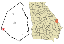
Location in Screven County and the state of Georgia
|
|
| Country | United States |
| State | Georgia |
| County | Screven |
| Area | |
| • Total | 1.24 sq mi (3.21 km2) |
| • Land | 1.21 sq mi (3.14 km2) |
| • Water | 0.03 sq mi (0.07 km2) |
| Elevation | 131 ft (40 m) |
| Population
(2020)
|
|
| • Total | 167 |
| • Density | 137.90/sq mi (53.25/km2) |
| Time zone | UTC-5 (Eastern (EST)) |
| • Summer (DST) | UTC-4 (EDT) |
| ZIP code |
30455
|
| Area code(s) | 912 |
| FIPS code | 13-66444 |
| GNIS feature ID | 0321840 |
Rocky Ford is a small town in Screven County, Georgia, United States. In 2020, about 167 people lived there.
History of Rocky Ford
This community got its name from a special place. There was a rocky ford (a shallow place to cross a river) over the nearby Ogeechee River.
Geography of Rocky Ford
Rocky Ford is located at 32°39′51″N 81°49′42″W / 32.66417°N 81.82833°W.
The town covers a total area of about 1.2 square miles (3.2 square kilometers). Most of this area is land. A very small part, about 0.04 square miles (0.1 square kilometers), is water.
Population Changes in Rocky Ford
| Historical population | |||
|---|---|---|---|
| Census | Pop. | %± | |
| 1910 | 385 | — | |
| 1920 | 522 | 35.6% | |
| 1930 | 370 | −29.1% | |
| 1940 | 320 | −13.5% | |
| 1950 | 278 | −13.1% | |
| 1960 | 241 | −13.3% | |
| 1970 | 252 | 4.6% | |
| 1980 | 223 | −11.5% | |
| 1990 | 197 | −11.7% | |
| 2000 | 186 | −5.6% | |
| 2010 | 144 | −22.6% | |
| 2020 | 167 | 16.0% | |
| U.S. Decennial Census 1850-1870 1870-1880 1890-1910 1920-1930 1940 1950 1960 1970 1980 1990 2000 |
|||
In the year 2000, 186 people lived in Rocky Ford. This included 78 households and 53 families. By 2020, the population had slightly decreased to 167 people.
In 2000, about 21.5% of the people were under 18 years old. About 21% were 65 years old or older. The average age of people in the town was 44 years.
See also
- In Spanish: Rocky Ford (Georgia) para niños
 | Dorothy Vaughan |
 | Charles Henry Turner |
 | Hildrus Poindexter |
 | Henry Cecil McBay |

