Jenkins County, Georgia facts for kids
Quick facts for kids
Jenkins County
|
|
|---|---|

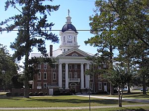
Jenkins County Courthouse, in Millen
|
|

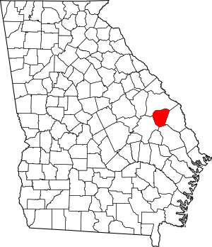
Location within the U.S. state of Georgia
|
|
 Georgia's location within the U.S. |
|
| Country | |
| State | |
| Founded | August 17, 1905 |
| Named for | Charles Jones Jenkins |
| Seat | Millen |
| Largest city | Millen |
| Area | |
| • Total | 352 sq mi (910 km2) |
| • Land | 347 sq mi (900 km2) |
| • Water | 5.2 sq mi (13 km2) 1.5%% |
| Population
(2020)
|
|
| • Total | 8,674 |
| • Density | 25/sq mi (10/km2) |
| Time zone | UTC−5 (Eastern) |
| • Summer (DST) | UTC−4 (EDT) |
| Congressional district | 12th |
Jenkins County is a special area, like a big neighborhood, located in the southeastern part of the U.S. state of Georgia. In 2020, about 8,674 people called Jenkins County home. The main town and center of the county's government is Millen. You can also visit the amazing Magnolia Springs State Park here, which is a popular spot for outdoor adventures!
Contents
History
Jenkins County was officially created on August 17, 1905. It was formed using parts of four nearby counties: Bulloch, Burke, Emanuel, and Screven. The county was named after Charles Jones Jenkins, who was the 44th Governor of Georgia.
A local leader named Robert Gray Daniel helped make Jenkins County happen. He was a director at the Millen Bank and worked on the school board for 40 years. His family had big businesses in farming and selling goods. The goal was to make Millen a safe place for businesses to grow. However, the first ten years were tough. Not many new businesses started, and some people left to find jobs in bigger cities.
In 1919, during a difficult time known as the "Red Summer," there was a serious event in Jenkins County. On April 13, 1919, white groups attacked the Black community. A respected local farmer named Joe Ruffin, whose family had been enslaved, faced many challenges. He spent a lot of money on legal help to clear his name.
Over time, businesses in Jenkins County have attracted workers from all around. When new jobs appear, the population tends to grow. If a big employer closes, people might move away to find work elsewhere. For many years, a company called Jockey International was the largest employer. They had many workers until they closed down in 2007. Another company, MI Windows and Doors, also had a factory here, which closed in late 2007.
Jenkins County also owns the Millen Airport. This airport helps people and businesses travel more easily. It has been a consistent benefit for the county's residents and companies.
Geography
The U.S. Census Bureau says that Jenkins County covers about 352 square miles. Most of this area, about 347 square miles, is land. The remaining 5.2 square miles, which is about 1.5%, is water.
Most of the southern part of Jenkins County is located in the Lower Ogeechee River area. This includes the region from southwest of Millen to west of Hiltonia. A very small part of the southwestern corner, near Garfield, is in the Canoochee River area. The northwestern part of Jenkins County is in the Upper Ogeechee River area. Finally, the northeastern corner of the county is in the Brier Creek area, which is part of the Savannah River system.
Major highways
Adjacent counties
- Burke County (north)
- Screven County (east)
- Bulloch County (south)
- Emanuel County (west)
Communities
City
Census-designated place
Demographics
| Historical population | |||
|---|---|---|---|
| Census | Pop. | %± | |
| 1910 | 11,520 | — | |
| 1920 | 14,328 | 24.4% | |
| 1930 | 12,908 | −9.9% | |
| 1940 | 11,843 | −8.3% | |
| 1950 | 10,264 | −13.3% | |
| 1960 | 9,148 | −10.9% | |
| 1970 | 8,332 | −8.9% | |
| 1980 | 8,841 | 6.1% | |
| 1990 | 8,247 | −6.7% | |
| 2000 | 8,575 | 4.0% | |
| 2010 | 8,340 | −2.7% | |
| 2020 | 8,674 | 4.0% | |
| 2023 (est.) | 8,627 | 3.4% | |
| U.S. Decennial Census 1790-1880 1890-1910 1920-1930 1930-1940 1940-1950 1960-1980 1980-2000 2010 |
|||
Jenkins County's population was highest in 1920. As of the 2020 United States census, there were 8,674 people living in the county. These people made up 3,443 households and 2,095 families.
| Race | Num. | Perc. |
|---|---|---|
| White (non-Hispanic) | 4,611 | 53.16% |
| Black or African American (non-Hispanic) | 3,536 | 40.77% |
| Native American | 29 | 0.33% |
| Asian | 12 | 0.14% |
| Pacific Islander | 5 | 0.06% |
| Other/Mixed | 178 | 2.05% |
| Hispanic or Latino | 303 | 3.49% |
See also
 In Spanish: Condado de Jenkins para niños
 | Bayard Rustin |
 | Jeannette Carter |
 | Jeremiah A. Brown |

