Emanuel County, Georgia facts for kids
Quick facts for kids
Emanuel County
|
|
|---|---|

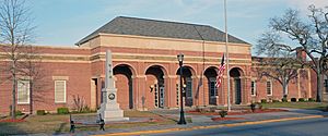
Emanuel County Courthouse
|
|

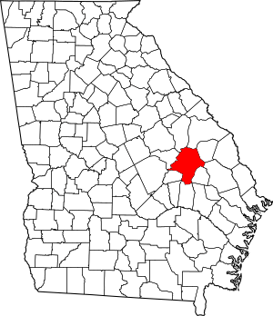
Location within the U.S. state of Georgia
|
|
 Georgia's location within the U.S. |
|
| Country | |
| State | |
| Founded | 1812 |
| Named for | David Emanuel |
| Seat | Swainsboro |
| Largest city | Swainsboro |
| Area | |
| • Total | 690 sq mi (1,800 km2) |
| • Land | 681 sq mi (1,760 km2) |
| • Water | 9.6 sq mi (25 km2) 1.4%% |
| Population
(2020)
|
|
| • Total | 22,768 |
| • Density | 33/sq mi (13/km2) |
| Time zone | UTC−5 (Eastern) |
| • Summer (DST) | UTC−4 (EDT) |
| Congressional district | 12th |
Emanuel County is a special area of land called a county in the eastern part of Georgia, a state in the United States. It's often called part of Georgia's "Classic South" region. In 2020, about 22,768 people lived here. The main town and center of the county government is Swainsboro.
Contents
History of Emanuel County
Emanuel County was created on December 10, 1812. This happened when the Georgia General Assembly (like Georgia's state government) decided to use parts of Bulloch and Montgomery counties to form it. The county is named after David Emanuel. He was a former Governor of Georgia.
Over the years, some parts of Emanuel County were used to create other counties. These include Johnson (in 1858), Jenkins (in 1905), Toombs (in 1905), Candler (in 1914), and Treutlen (in 1918).
Courthouses in Emanuel County
Emanuel County has had many courthouses in its history. A courthouse is where the county's legal and government work happens. In the early days, the court met at a person's home. The first official courthouse was built in 1814. Sadly, it burned down in 1841.
After that, several other courthouses were built. But they also burned down over the years. One was built in 1854 and burned in 1855. Another was built and burned in 1857. A fourth courthouse burned in 1919. Then, a three-story brick building was put up, but it also burned in 1938.
The next courthouse was built in 1940. It was made of marble and was the first one not to be destroyed by fire. However, by the 1990s, it became too small and old. Many county offices had to move to other buildings. This courthouse was taken down in 2000.
In the late 1990s, the county bought an old Post Office building to use as a temporary courthouse. In 2000, more land was bought next to it. A new, large brick courthouse was finished in 2002. This new building included the old Post Office. The spot where the old courthouse stood became a city square.
Geography of Emanuel County
Emanuel County covers about 690 square miles. Most of this area, about 681 square miles, is land. The rest, about 9.6 square miles, is water.
The county is part of different river systems. The northern part is in the Ogeechee River basin. The eastern part, near Swainsboro, is in the Canoochee River sub-basin. The western and southern parts are in the Ohoopee River sub-basin, which is part of the larger Altamaha River basin.
Major Roads in Emanuel County
 Interstate 16
 U.S. Route 1
 U.S. Route 1 Business
 U.S. Route 80
 U.S. Route 221
 State Route 4
 State Route 4 Business
 State Route 15
 State Route 23
 State Route 26
 State Route 46
 State Route 56
 State Route 57
 State Route 78
 State Route 86
 State Route 121
 State Route 171
 State Route 192
 State Route 297
 State Route 404 (this is another name for I-16)
Neighboring Counties
- Jefferson County - north
- Jenkins County - northeast
- Burke County - northeast
- Candler County - east
- Tattnall County - southeast
- Bulloch County - southeast
- Toombs County - south
- Johnson County - west
- Treutlen County - west
Towns and Communities
Cities in Emanuel County
- Adrian
- Garfield
- Nunez
- Oak Park
- Stillmore
- Summertown
- Swainsboro
- Twin City
Census-Designated Places
These are areas that are like towns but are not officially incorporated as cities.
Unincorporated Communities
These are smaller communities that are not part of any city or census-designated place.
- Five Points, Georgia
- Stevens Crossing, Georgia
Population and People
| Historical population | |||
|---|---|---|---|
| Census | Pop. | %± | |
| 1820 | 2,928 | — | |
| 1830 | 2,673 | −8.7% | |
| 1840 | 3,129 | 17.1% | |
| 1850 | 4,577 | 46.3% | |
| 1860 | 5,081 | 11.0% | |
| 1870 | 6,134 | 20.7% | |
| 1880 | 9,759 | 59.1% | |
| 1890 | 14,703 | 50.7% | |
| 1900 | 21,279 | 44.7% | |
| 1910 | 25,140 | 18.1% | |
| 1920 | 25,862 | 2.9% | |
| 1930 | 24,101 | −6.8% | |
| 1940 | 23,517 | −2.4% | |
| 1950 | 19,789 | −15.9% | |
| 1960 | 17,815 | −10.0% | |
| 1970 | 18,189 | 2.1% | |
| 1980 | 20,795 | 14.3% | |
| 1990 | 20,546 | −1.2% | |
| 2000 | 21,837 | 6.3% | |
| 2010 | 22,598 | 3.5% | |
| 2020 | 22,768 | 0.8% | |
| 2023 (est.) | 23,119 | 2.3% | |
| U.S. Decennial Census 1790-1880 1890-1910 1920-1930 1930-1940 1940-1950 1960-1980 1980-2000 2010 |
|||
Here's a look at the different groups of people living in Emanuel County as of 2020:
| Race | Number of People | Percentage |
|---|---|---|
| White (not Hispanic) | 13,815 | 60.68% |
| Black or African American (not Hispanic) | 7,246 | 31.83% |
| Native American | 33 | 0.14% |
| Asian | 141 | 0.62% |
| Pacific Islander | 2 | 0.01% |
| Other/Mixed | 538 | 2.36% |
| Hispanic or Latino | 993 | 4.36% |
In 2020, there were 22,768 people living in the county. These people lived in 8,387 households, and 5,683 of these were families.
See also
 In Spanish: Condado de Emanuel para niños
 | Kyle Baker |
 | Joseph Yoakum |
 | Laura Wheeler Waring |
 | Henry Ossawa Tanner |

