Candler County, Georgia facts for kids
Quick facts for kids
Candler County
|
||
|---|---|---|

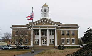
Candler County Courthouse, in Metter
|
||
|
||

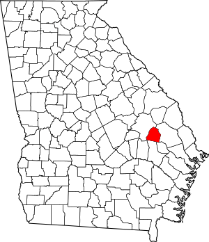
Location within the U.S. state of Georgia
|
||
 Georgia's location within the U.S. |
||
| Country | ||
| State | ||
| Founded | 1914 | |
| Named for | Allen D. Candler | |
| Seat | Metter | |
| Largest city | Metter | |
| Area | ||
| • Total | 249 sq mi (640 km2) | |
| • Land | 243 sq mi (630 km2) | |
| • Water | 5.8 sq mi (15 km2) 2.3%% | |
| Population
(2020)
|
||
| • Total | 10,981 | |
| • Density | 45/sq mi (17/km2) | |
| Time zone | UTC−5 (Eastern) | |
| • Summer (DST) | UTC−4 (EDT) | |
| Congressional district | 12th | |
Candler County is a county located in the southeastern part of the U.S. state of Georgia. It's a place where about 10,981 people lived as of the 2020 census. The main town and county seat is Metter. The county was started in 1914. It was named after Allen D. Candler, who was the 56th governor of Georgia.
Contents
Geography of Candler County
Candler County covers a total area of about 249 square miles. Most of this area, about 243 square miles, is land. The rest, about 5.8 square miles, is water. This means water makes up about 2.3% of the county's total area.
Most of Candler County is located in the Canoochee River area. This river flows into the larger Ogeechee River. The western part of the county, west of State Route 57, is in the Ohoopee River area. The Ohoopee River flows into the Altamaha River.
Major Roads in Candler County
These are the main highways that run through Candler County:
 Interstate 16
 State Route 23
 State Route 46
 State Route 57
 State Route 121
 State Route 129
 State Route 404 (This is another name for I-16)
Neighboring Counties
Candler County shares its borders with these other counties:
- Bulloch County (to the east)
- Evans County (to the southeast)
- Tattnall County (to the south)
- Emanuel County (to the northwest)
Towns and Cities
Candler County has a few communities where people live.
City
- Metter (This is the largest city and the county seat)
Town
Population of Candler County
| Historical population | |||
|---|---|---|---|
| Census | Pop. | %± | |
| 1920 | 9,228 | — | |
| 1930 | 8,991 | −2.6% | |
| 1940 | 9,103 | 1.2% | |
| 1950 | 8,063 | −11.4% | |
| 1960 | 6,672 | −17.3% | |
| 1970 | 6,412 | −3.9% | |
| 1980 | 7,518 | 17.2% | |
| 1990 | 7,744 | 3.0% | |
| 2000 | 9,577 | 23.7% | |
| 2010 | 10,998 | 14.8% | |
| 2020 | 10,981 | −0.2% | |
| 2023 (est.) | 11,059 | 0.6% | |
| U.S. Decennial Census 1790-18801890-1910 1920-1930 1930-1940 1940-1950 1960-1980 1980-2000 2010 |
|||
The population of Candler County has changed over the years. In 2020, the 2020 United States census counted 10,981 people living here. There were 4,013 households and 2,775 families in the county at that time.
Education
See also
 In Spanish: Condado de Candler para niños
 | DeHart Hubbard |
 | Wilma Rudolph |
 | Jesse Owens |
 | Jackie Joyner-Kersee |
 | Major Taylor |


