
Tattnall County, Georgia facts for kids
Quick facts for kids
Tattnall County
|
|
|---|---|

Tattnall County Courthouse
|
|

Location within the U.S. state of Georgia
|
|
 Georgia's location within the U.S. |
|
| Country | |
| State | |
| Founded | December 5, 1801 |
| Named for | Josiah Tattnall |
| Seat | Reidsville |
| Largest city | Glennville |
| Area | |
| • Total | 488 sq mi (1,260 km2) |
| • Land | 479 sq mi (1,240 km2) |
| • Water | 8.9 sq mi (23 km2) 1.8%% |
| Population
(2020)
|
|
| • Total | 22,842 |
| • Density | 48/sq mi (19/km2) |
| Time zone | UTC−5 (Eastern) |
| • Summer (DST) | UTC−4 (EDT) |
| Congressional district | 12th |
Tattnall County is a place in the southeast part of Georgia. It's part of a bigger area called the Magnolia Midlands. In 2020, about 22,842 people lived there. The main town, or county seat, is Reidsville.
Tattnall County was officially started on December 5, 1801. It was formed from a part of Montgomery County, Georgia. The county is named after Josiah Tattnall. He was a soldier and politician long ago.
Contents
Exploring Tattnall County's Geography
Tattnall County covers about 488 square miles. Most of this area, about 479 square miles, is land. The rest, about 8.9 square miles, is water.
Rivers and Waterways
Many rivers flow through Tattnall County. The western part of the county is in the Ohoopee River area. This river flows into the larger Altamaha River. The northeastern part of the county is near the Canoochee River. This river flows into the Ogeechee River. Other parts of the county are also in the Altamaha River area.
Main Roads in Tattnall County
Many important roads help people travel through Tattnall County. These roads connect the county to other places in Georgia.

 US 25 / US 301
 US 280
 SR 23
SR 23 SR 30
SR 30 SR 56
SR 56 SR 57
SR 57 SR 73
SR 73 SR 121
 SR 129
 SR 144
 SR 147
 SR 152
 SR 169
 SR 178
 SR 292
Neighboring Counties
Tattnall County shares its borders with several other counties in Georgia.
- Candler County - to the north
- Evans County - to the northeast
- Liberty County - to the east
- Long County - to the southeast
- Wayne County - to the south
- Appling County - to the southwest
- Toombs County - to the west
- Emanuel County - to the northwest
Towns and Communities
Tattnall County has several towns and one special community.
Cities
- Cobbtown
- Collins
- Glennville (This is the biggest city in the county.)
- Manassas
- Reidsville (This is the county seat, where the main government offices are.)
Census-Designated Place
- Mendes (This is a community that the U.S. Census Bureau counts for statistics.)
People of Tattnall County
The number of people living in Tattnall County has changed over many years.
| Historical population | |||
|---|---|---|---|
| Census | Pop. | %± | |
| 1810 | 2,206 | — | |
| 1820 | 2,644 | 19.9% | |
| 1830 | 2,040 | −22.8% | |
| 1840 | 2,724 | 33.5% | |
| 1850 | 3,227 | 18.5% | |
| 1860 | 4,352 | 34.9% | |
| 1870 | 4,860 | 11.7% | |
| 1880 | 6,988 | 43.8% | |
| 1890 | 10,253 | 46.7% | |
| 1900 | 20,419 | 99.2% | |
| 1910 | 18,569 | −9.1% | |
| 1920 | 14,502 | −21.9% | |
| 1930 | 15,411 | 6.3% | |
| 1940 | 16,243 | 5.4% | |
| 1950 | 15,939 | −1.9% | |
| 1960 | 15,837 | −0.6% | |
| 1970 | 16,557 | 4.5% | |
| 1980 | 18,134 | 9.5% | |
| 1990 | 17,722 | −2.3% | |
| 2000 | 22,305 | 25.9% | |
| 2010 | 25,520 | 14.4% | |
| 2020 | 22,842 | −10.5% | |
| 2023 (est.) | 24,296 | −4.8% | |
| U.S. Decennial Census 1790-1880 1890-1910 1920-1930 1930-1940 1940-1950 1960-1980 1980-2000 2010 |
|||
Diversity in Tattnall County (2020)
The table below shows the different groups of people living in Tattnall County in 2020. This helps us understand the mix of cultures and backgrounds in the area.
| Race | Num. | Perc. |
|---|---|---|
| White (non-Hispanic) | 13,825 | 60.52% |
| Black or African American (non-Hispanic) | 5,961 | 26.1% |
| Native American | 36 | 0.16% |
| Asian | 127 | 0.56% |
| Pacific Islander | 6 | 0.03% |
| Other/Mixed | 584 | 2.56% |
| Hispanic or Latino | 2,303 | 10.08% |
In 2020, there were 22,842 people living in the county. These people lived in 8,241 households. About 5,875 of these households were families.
Education in Tattnall County
Most students in Tattnall County go to schools run by the Tattnall County School District. This district provides education from kindergarten through 12th grade.
However, some parts of the county are near Fort Stewart. Children living on Fort Stewart attend elementary schools run by the Department of Defense Education Activity (DoDEA). When these students reach middle and high school, they attend public schools in the nearby county school districts.
Images for kids
-
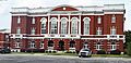
The Tattnall County Courthouse in Reidsville.
See also
 In Spanish: Condado de Tattnall para niños
