Wayne County, Georgia facts for kids
Quick facts for kids
Wayne County
|
|
|---|---|

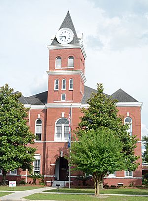
Wayne County courthouse in Jesup
|
|

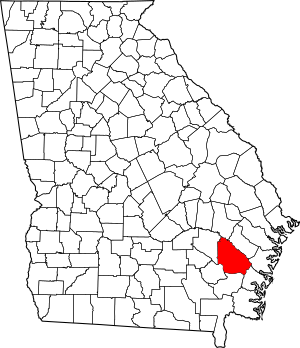
Location within the U.S. state of Georgia
|
|
 Georgia's location within the U.S. |
|
| Country | |
| State | |
| Founded | December 7, 1803 |
| Named for | Anthony Wayne |
| Seat | Jesup |
| Largest city | Jesup |
| Area | |
| • Total | 649 sq mi (1,680 km2) |
| • Land | 642 sq mi (1,660 km2) |
| • Water | 7.0 sq mi (18 km2) 1.1%% |
| Population
(2020)
|
|
| • Total | 30,144 |
| • Density | 47/sq mi (18/km2) |
| Time zone | UTC−5 (Eastern) |
| • Summer (DST) | UTC−4 (EDT) |
| Congressional district | 1st |
Wayne County is a place in the U.S. state of Georgia. It is located in the southeastern part of the state. In 2020, about 30,144 people lived there. The main town and county seat is Jesup. Wayne County is part of the Jesup, Georgia, area.
Contents
History of Wayne County
When Europeans first arrived, the Guale people lived in the area that is now Wayne County. Because it was near the coast and the Altamaha River, many groups were interested in this land. Spanish missionaries settled here when Saint Augustine was founded. The French also lived here for a short time. Over the years, flags from France, Spain, England, and the Confederate States of America have flown over Wayne County.
How Wayne County Started
Wayne County was created in 1803. This was 70 years after General James Oglethorpe started the Georgia colony. It was also 27 years after Georgia became one of the first 13 states. The county was named after Anthony Wayne, a famous military hero. He was known as "Mad Anthony" after a surprise attack in 1779. He was an important part of General George Washington's team.
The county was formed after a treaty with the Creek Indians in 1802. Wayne County was the 28th county in Georgia. It was a long, narrow strip of land, about 100 miles (160 km) long. Its width changed from 6 miles (9.7 km) to 8 miles (13 km). At first, land was given away, but this system had problems. A new system, called the Land Lottery Act of 1805, was created. This act divided the land and allowed for more people to settle. The county celebrates December 7, 1805, as its official creation date.
Finding a County Seat
Wayne County grew slowly at first. People were not in a hurry to set up a government center. In 1806, the Georgia General Assembly chose five people to find a permanent county seat. They decided that county court would be held at Roberta Smallwood's home for a while. In 1808, new people were chosen to find a county seat. The first spot was not central enough. Court then moved to Captain William Clements' house.
In 1823, another group of people was chosen to find a county seat. The first post office in Wayne County opened in Tuckersville in 1814. Tuckersville was the county seat for a time. It disappeared from maps by 1850, and its exact location is still a mystery.
In 1829, Waynesville, Georgia became Wayne County's first official county seat. It was chosen because it was central for settlers. Waynesville also had the first school, called Mineral Springs Academy. It was named after nearby mineral springs. In 1832, voters asked for another group to find a more central county seat. Waynesville was still used as the county seat in the early 1840s. In 1847, new people were chosen to find a county seat near William Flowers' home.
In 1856, people in Wayne County voted on whether to move the county seat.
Jesup Becomes the New County Seat
The city of Jesup became the county seat on October 24, 1870. At that time, Jesup was part of Appling County. Jesup grew because of its first mayor, Willis Clary. He helped the Macon and Brunswick Railroad cross the Atlantic and Gulf Railroad tracks in Jesup. In 1872, parts of Appling County were added to Wayne County. Jesup has always been a railway town. By 1891, many people in the town worked for the railroads.
In 1873, the Georgia General Assembly held a vote to move the county seat. Voters could choose "No removal," "Removal, Jesup," "Removal, Waynesville," or "Removal, Screven." Jesup was chosen as the new county seat.
Screven and Odum
The cities of Screven and Odum are also old railroad towns. Screven was officially started in 1854. It became a stop on the Atlantic and Gulf Railroad. This rail line connected Screven to Thomasville, a popular resort city. Screven was named after the family who ran the railroad. C. C. Grace helped build the community.
Similarly, Godfrey Odum helped build the town of Odum. Odum became a stop on the Macon and Brunswick Railroad. It was known by other names like Satilla and Haslum before. Railroads made it easy to ship turpentine and sawmill products from Odum to bigger markets.
Henry W. Grady once said that South Georgia was mostly good for pine trees and cows. Pine trees have been very important to Wayne County. Products from pine trees, like turpentine and other naval stores, helped communities grow. Schools and churches appeared along the railroads and rivers. Places like Mount Pleasant, Gardi, McKinnon, Doctortown, Manningtown, Brentwood, Ritch, O'Quinn, Madray Springs, and Piney Grove were important family centers.
Geography
Wayne County covers about 649 square miles (1,680 km²). Most of this area, 642 square miles (1,660 km²), is land. About 7.0 square miles (18 km²) is water.
The northern and eastern parts of Wayne County are in the Altamaha River area. The western side of the county is in the Little Satilla River area. A small southern part of the county is in the Satilla River area.
Major Roads
 US 25
US 25 US 84
US 84 US 301
 US 341
 SR 23
SR 23 SR 27
SR 27 SR 38
SR 38 SR 169
 SR 203
Neighboring Counties
- Tattnall County (north)
- Long County (northeast)
- McIntosh County (east)
- Glynn County (southeast)
- Brantley County (south)
- Pierce County (southwest)
- Appling County (northwest)
Communities
Cities
Town
Unincorporated Communities
- Akin
- Brentwood
- Doctortown
- Gardi
- Madray Springs
- Manningtown
Former Communities
- Dales Mill
- Fort Barrington
- Pendarvis
- Tuckersville
- Waynesville
- Williamsburg
Population Information
| Historical population | |||
|---|---|---|---|
| Census | Pop. | %± | |
| 1810 | 676 | — | |
| 1820 | 1,010 | 49.4% | |
| 1830 | 963 | −4.7% | |
| 1840 | 1,258 | 30.6% | |
| 1850 | 1,499 | 19.2% | |
| 1860 | 2,268 | 51.3% | |
| 1870 | 2,177 | −4.0% | |
| 1880 | 5,980 | 174.7% | |
| 1890 | 7,485 | 25.2% | |
| 1900 | 9,449 | 26.2% | |
| 1910 | 13,069 | 38.3% | |
| 1920 | 14,381 | 10.0% | |
| 1930 | 12,647 | −12.1% | |
| 1940 | 13,122 | 3.8% | |
| 1950 | 14,248 | 8.6% | |
| 1960 | 17,921 | 25.8% | |
| 1970 | 17,858 | −0.4% | |
| 1980 | 20,750 | 16.2% | |
| 1990 | 22,356 | 7.7% | |
| 2000 | 26,565 | 18.8% | |
| 2010 | 30,099 | 13.3% | |
| 2020 | 30,144 | 0.1% | |
| 2023 (est.) | 31,373 | 4.2% | |
| U.S. Decennial Census 1790-1880 1890-1910 1920-1930 1930-1940 1940-1950 1960-1980 1980-2000 2010 |
|||
In 2020, there were 30,144 people living in Wayne County. There were about 10,400 households and 7,166 families. The average income for a household was $45,773.
| Group | Number | Percent |
|---|---|---|
| White (not Hispanic) | 21,301 | 76.0% |
| Black or African American (not Hispanic) | 5,877 | 20.8% |
| Native American | 58 | 0.7% |
| Asian | 92 | 0.8% |
| Pacific Islander | 2 | 0.1% |
| Other/Mixed Race | 1,000 | 2.2% |
| Hispanic or Latino | 1,732 | 6.7% |
Education
The Wayne County School District runs the public schools in the area.
Notable People
- Anne Nichols (1891-1966), from Dales Mill, was a writer. She is best known for her play Abie's Irish Rose.
- David Larson from Jesup won a gold medal in swimming at the 1984 Summer Olympics.
- Howard E. Wasdin received the Purple Heart and Silver Star medals. He was a sniper in the Navy.
See also
 In Spanish: Condado de Wayne (Georgia) para niños
 | Jackie Robinson |
 | Jack Johnson |
 | Althea Gibson |
 | Arthur Ashe |
 | Muhammad Ali |


