
Thomasville, Georgia facts for kids
Quick facts for kids
Thomasville, Georgia
|
||
|---|---|---|

Thomas County Courthouse
|
||
|
||
| Nickname(s):
"T-Ville", The City of Roses, The Rose City, Beacon Hills (original name)
|
||

Location in Thomas County and the state of Georgia
|
||

Thomasville, Georgia
Location in the United States
|
||
| Country | United States | |
| State | Georgia | |
| County | Thomas | |
| Area | ||
| • City | 15.15 sq mi (39.23 km2) | |
| • Land | 15.01 sq mi (38.88 km2) | |
| • Water | 0.13 sq mi (0.34 km2) | |
| Elevation | 279 ft (85 m) | |
| Population
(2020)
|
||
| • City | 18,881 | |
| • Density | 1,257.64/sq mi (485.58/km2) | |
| • Metro | 45,000 | |
| Time zone | UTC-5 (Eastern (EST)) | |
| • Summer (DST) | UTC-4 (EDT) | |
| ZIP codes |
31792, 31799
|
|
| Area code(s) | 229 | |
| FIPS code | 13-76224 | |
| GNIS feature ID | 0333216 | |
Thomasville is a city in Georgia, United States. It is the main city of Thomas County. In 2020, about 18,881 people lived there.
Thomasville is known as the "City of Roses." Every year, it hosts a fun Rose Festival. The city has many interesting places to visit, like old plantations, a lively downtown area, and a big farmer's market. You can also see a very old oak tree, which is about 340 years old!
Contents
History of Thomasville
Thomasville was started in 1825. It became the main city for the new Thomas County. It was officially made a town in 1831 and then a city in 1889. The city was named after Jett Thomas, a general who fought in the War of 1812.
Geography and Climate
Thomasville covers about 15 square miles (39 square kilometers). Most of this area is land, with a small part being water. It is the second largest city in Southwest Georgia, after Albany.
You can reach Thomasville using three major U.S. roads: Route 19, Route 84, and Route 319. It is located near several other cities:
- 34 miles northeast of Tallahassee, Florida
- 28 miles southwest of Moultrie
- 43 miles west of Valdosta
- 59 miles south of Albany
Thomasville's Weather
Thomasville has a humid subtropical climate. This means it has hot, humid summers. The winters are usually mild and cool.
| Climate data for Thomasville, Georgia | |||||||||||||
|---|---|---|---|---|---|---|---|---|---|---|---|---|---|
| Month | Jan | Feb | Mar | Apr | May | Jun | Jul | Aug | Sep | Oct | Nov | Dec | Year |
| Record high °F (°C) | 86 (30) |
86 (30) |
96 (36) |
96 (36) |
102 (39) |
104 (40) |
106 (41) |
104 (40) |
106 (41) |
97 (36) |
89 (32) |
85 (29) |
106 (41) |
| Mean daily maximum °F (°C) | 63 (17) |
68 (20) |
73 (23) |
79 (26) |
86 (30) |
90 (32) |
92 (33) |
91 (33) |
87 (31) |
81 (27) |
73 (23) |
65 (18) |
79 (26) |
| Mean daily minimum °F (°C) | 39 (4) |
42 (6) |
47 (8) |
53 (12) |
61 (16) |
69 (21) |
71 (22) |
71 (22) |
67 (19) |
57 (14) |
49 (9) |
41 (5) |
56 (13) |
| Record low °F (°C) | 5 (−15) |
11 (−12) |
19 (−7) |
30 (−1) |
41 (5) |
48 (9) |
56 (13) |
53 (12) |
37 (3) |
26 (−3) |
11 (−12) |
8 (−13) |
5 (−15) |
| Average precipitation inches (mm) | 4.80 (122) |
4.88 (124) |
5.67 (144) |
3.08 (78) |
3.00 (76) |
5.84 (148) |
5.68 (144) |
5.72 (145) |
4.52 (115) |
3.02 (77) |
3.44 (87) |
3.65 (93) |
53.3 (1,353) |
| Source: The Weather Channel | |||||||||||||
People of Thomasville
| Historical population | |||
|---|---|---|---|
| Census | Pop. | %± | |
| 1870 | 1,651 | — | |
| 1880 | 2,555 | 54.8% | |
| 1890 | 5,514 | 115.8% | |
| 1900 | 5,322 | −3.5% | |
| 1910 | 6,727 | 26.4% | |
| 1920 | 8,196 | 21.8% | |
| 1930 | 11,733 | 43.2% | |
| 1940 | 12,683 | 8.1% | |
| 1950 | 14,424 | 13.7% | |
| 1960 | 18,246 | 26.5% | |
| 1970 | 18,155 | −0.5% | |
| 1980 | 18,463 | 1.7% | |
| 1990 | 17,457 | −5.4% | |
| 2000 | 18,162 | 4.0% | |
| 2010 | 18,413 | 1.4% | |
| 2020 | 18,881 | 2.5% | |
In 2020, there were 18,881 people living in Thomasville. There were 7,529 households and 4,983 families.
| Race | Num. | Perc. |
|---|---|---|
| White | 7,666 | 40.6% |
| Black or African American | 9,874 | 52.3% |
| Native American | 40 | 0.21% |
| Asian | 212 | 1.12% |
| Pacific Islander | 6 | 0.03% |
| Other/Mixed | 571 | 3.02% |
| Hispanic or Latino | 512 | 2.71% |
Economy and Jobs
Thomasville is home to several important companies.
- Flowers Foods, a large bakery company, has its main office here.
- Senior Life Insurance Company and Archbold Medical Center are also based in Thomasville. These businesses provide many jobs for the community.
Arts and Culture
Thomasville is famous for its beautiful roses. The city takes care of over 1,000 rose bushes. Many people who live there also have their own rose gardens.
Annual Rose Festival
Every year in late April, Thomasville hosts its annual Rose Festival. Rose growers from all over the world come to show off their best roses. Judges pick the most beautiful ones. The biggest rose garden in the city is at Cherokee Lake Park. It has 85 rose beds and is the main spot for the festival.
Museums and Historic Sites
Thomasville has many places where you can learn about history and art:
- The Thomas County Historical Society and Museum of History
- Thomasville Landmarks, Inc.
- The Thomasville Center for the Arts
- The Jack Hadley Black History Museum
- Pebble Hill Plantation, a historic estate
You can visit these places for tours and research.
MLK Walk and Festival
Since 2009, Thomasville has held an annual MLK (Rev. Dr. Martin Luther King, Jr.) Walk and Festival in January. This event celebrates the life and work of Dr. King.
Education in Thomasville
Thomasville has several schools, from pre-school to college.
Public Schools
There are two main public school districts:
- Thomasville City School District: This district serves students from pre-school to 12th grade. It has three elementary schools, one middle school, and Thomasville High School. There are over 3,107 students and 204 teachers.
- Thomas County School District: This district also serves students from pre-school to 12th grade. It has three elementary schools, one middle school, and two high schools: Thomas County Central High School and Bishop Hall Charter School. This district has over 5,466 students and 329 teachers.
Private Schools
- Thomasville Christian School (Pre-K to 9th grade)
- Brookwood School (Pre-K to 12th grade) - This is an independent school that helps students get ready for college.
Colleges and Universities
- Thomas University - This is a four-year university with its main campus in Thomasville.
- Southern Regional Technical College - This college offers technical training and degrees.
Media and Communications
Thomasville has its own newspaper and radio stations.
Newspaper
- The Thomasville Times-Enterprise is a daily newspaper. It also publishes a magazine called Thomasville Scene.
Radio Stations
- WPAX 1240 AM
- WHGH
- WSTT
City Services and Technology
Thomasville has a special fiber optic network called CNS. This network provides fast and affordable internet to homes and businesses. It has been in place since 1999.
The money earned from CNS and other city services helps pay for important things like police, fire protection, and street repairs. Because of these earnings, the city was able to remove the property fire tax for its residents and businesses in 2012.
Famous People from Thomasville
Many notable people have connections to Thomasville:
- William Andrews – Played football for the Atlanta Falcons.
- Lloyd J. Austin – A general in the U.S. Army and the United States Secretary of Defense.
- Stephanie Bentley – A country music singer.
- Elbridge Bryant – One of the first members of the famous music group The Temptations.
- Joe Burns – Played football for the Buffalo Bills.
- Joelle Carter – An actress.
- Tashard Choice – Played football for the Dallas Cowboys.
- Danny Copeland – Played football for the Washington Redskins (who won the Super Bowl).
- Henry Elrod – A brave U.S. Marine captain who received the Medal of Honor.
- Harris English – A professional golfer.
- Mary Lena Faulk – A professional golfer and one of the people who started the LPGA.
- Henry Ossian Flipper – The first African American to graduate from West Point.
- Myron Guyton – Played football for the New York Giants and New England Patriots.
- Sam Madison – Played football for the Miami Dolphins and New York Giants.
- Guy McIntyre – Played football for the San Francisco 49ers.
- Delia Owens - A well-known author.
- Marcus Stroud – Played football in the NFL.
- Brandon Thompson – Played football in the NFL.
- Dina Titus – A member of the U.S. House of Representatives.
- Charlie Ward Jr. – A Heisman Trophy winner in college football and played basketball for the New York Knicks.
- Bailey White – An author.
- Scott Wilson – An actor.
- Joanne Woodward – An Academy Award-winning actress and helper of good causes.
- Andrew Young – A leader in the civil rights movement and an ambassador to the United Nations.
Images for kids
-
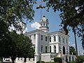
The Thomas County Courthouse.
-
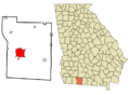
Map showing Thomasville in Thomas County, Georgia.
-

The official logo of Thomasville, Georgia.
See also
 In Spanish: Thomasville (Georgia) para niños
