Thomas County, Georgia facts for kids
Quick facts for kids
Thomas County
|
|
|---|---|

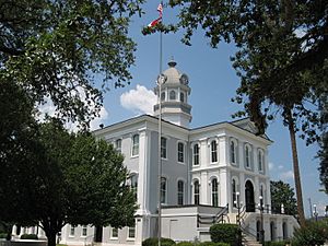
Former Thomas County Courthouse in Thomasville
|
|

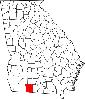
Location within the U.S. state of Georgia
|
|
 Georgia's location within the U.S. |
|
| Country | |
| State | |
| Founded | December 23, 1825 |
| Named for | Jett Thomas |
| Seat | Thomasville |
| Largest city | Thomasville |
| Area | |
| • Total | 552 sq mi (1,430 km2) |
| • Land | 545 sq mi (1,410 km2) |
| • Water | 7.6 sq mi (20 km2) 1.4%% |
| Population
(2020)
|
|
| • Total | 45,798 |
| • Estimate
(2023)
|
45,649 |
| • Density | 82.97/sq mi (32.034/km2) |
| Time zone | UTC−5 (Eastern) |
| • Summer (DST) | UTC−4 (EDT) |
| Congressional district | 8th |
Thomas County is a county located in the state of Georgia in the United States. In 2020, about 45,798 people lived here. The main town and county seat (where the county government is) is Thomasville. Thomas County is part of the Thomasville, GA area, which is a smaller city area.
Contents
History of Thomas County
Thomas County was created on December 23, 1825. It was formed from parts of Decatur and Irwin Counties. Later, other counties like Colquitt (1856), Brooks (1858), and Grady (1905) were partly made from land that used to be in Thomas County.
The county is named after Jett Thomas. He was an officer who fought in the War of 1812. He also helped build the first building at the University of Georgia. This building was first called Franklin College. Today, it is known as Old College. Jett Thomas also oversaw the building of the state capital in Milledgeville.
Geography and Nature
According to the U.S. Census Bureau, Thomas County covers about 552 square miles. Most of this area, about 545 square miles, is land. The rest, about 7.6 square miles (1.4%), is water.
The northwestern part of Thomas County is in the Upper Ochlockonee River area. The northeastern edge is in the Withlacoochee River area. The southeastern part is in the Aucilla River area. The southwestern part is mostly in the Apalachee Bay-St. Marks area.
The Aucilla River actually starts in Thomas County. The Red Hills Region, known for its rolling hills and rich soil, is mostly found in Thomas County.
Main Roads in Thomas County
Neighboring Counties
Thomas County shares borders with these other counties:
- Colquitt County - to the northeast
- Brooks County - to the east
- Jefferson County, Florida - to the south
- Leon County, Florida - to the southwest
- Grady County - to the west
- Mitchell County - to the northwest
Communities in Thomas County
Thomas County has several cities and one town. It also has an unincorporated community.
Cities
- Barwick (partly in Brooks County)
- Boston
- Coolidge
- Meigs (partly in Mitchell County)
- Pavo (partly in Brooks County)
- Thomasville
Town
Unincorporated community
Population and People
The population of Thomas County has changed over many years. Here's how it has grown:
| Historical population | |||
|---|---|---|---|
| Census | Pop. | %± | |
| 1830 | 3,299 | — | |
| 1840 | 6,766 | 105.1% | |
| 1850 | 10,103 | 49.3% | |
| 1860 | 10,766 | 6.6% | |
| 1870 | 14,523 | 34.9% | |
| 1880 | 20,597 | 41.8% | |
| 1890 | 26,154 | 27.0% | |
| 1900 | 31,076 | 18.8% | |
| 1910 | 29,071 | −6.5% | |
| 1920 | 33,044 | 13.7% | |
| 1930 | 32,612 | −1.3% | |
| 1940 | 31,289 | −4.1% | |
| 1950 | 33,932 | 8.4% | |
| 1960 | 34,319 | 1.1% | |
| 1970 | 34,515 | 0.6% | |
| 1980 | 38,098 | 10.4% | |
| 1990 | 38,986 | 2.3% | |
| 2000 | 42,737 | 9.6% | |
| 2010 | 44,720 | 4.6% | |
| 2020 | 45,798 | 2.4% | |
| 2023 (est.) | 45,649 | 2.1% | |
| U.S. Decennial Census 1790-1880 1890-1910 1920-1930 1930-1940 1940-1950 1960-1980 1980-2000 2010 |
|||
Here's a look at the different groups of people living in Thomas County in 2020:
| Race | Num. | Perc. |
|---|---|---|
| White | 25,994 | 56.76% |
| Black or African American | 16,259 | 35.5% |
| Native American | 150 | 0.33% |
| Asian | 406 | 0.89% |
| Pacific Islander | 9 | 0.02% |
| Other/Mixed | 1,403 | 3.06% |
| Hispanic or Latino | 1,577 | 3.44% |
In 2020, there were 45,798 people living in Thomas County. There were 17,595 households (groups of people living together) and 12,161 families.
Education in Thomas County
Thomas County has several places for learning, from colleges to schools.
Colleges and Universities
- Thomas University
- Southern Regional Technical College
School Districts
There are two main school districts:
- Thomasville City School District (for areas inside Thomasville City)
- Thomas County School District (for areas not inside Thomasville City)
Private Schools
- Brookwood School
See also
 In Spanish: Condado de Thomas (Georgia) para niños
 | Calvin Brent |
 | Walter T. Bailey |
 | Martha Cassell Thompson |
 | Alberta Jeannette Cassell |

