Decatur County, Georgia facts for kids
Quick facts for kids
Decatur County
|
|
|---|---|

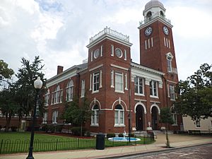
Decatur County Courthouse in Bainbridge
|
|

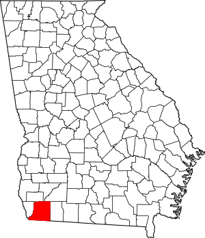
Location within the U.S. state of Georgia
|
|
 Georgia's location within the U.S. |
|
| Country | |
| State | |
| Founded | 1823 |
| Named for | Stephen Decatur |
| Seat | Bainbridge |
| Largest city | Bainbridge |
| Area | |
| • Total | 623 sq mi (1,610 km2) |
| • Land | 597 sq mi (1,550 km2) |
| • Water | 26 sq mi (70 km2) 4.2%% |
| Population
(2020)
|
|
| • Total | 29,367 |
| • Density | 49/sq mi (19/km2) |
| Time zone | UTC−5 (Eastern) |
| • Summer (DST) | UTC−4 (EDT) |
| Congressional district | 2nd |
Decatur County is a county in the state of Georgia. In 2020, about 29,367 people lived here. The main town, or county seat, is Bainbridge.
Decatur County is part of the Bainbridge, GA Micropolitan Statistical Area. This area is also included in the larger Tallahassee—Bainbridge, FL-GA Combined Statistical Area.
Contents
History of Decatur County
Decatur County was created on December 8, 1823. It was formed from a part of Early County. Over the years, parts of Decatur County were used to create other counties.
In 1825, some land from Decatur County became part of Thomas County. Later, in 1905, another piece of land helped form Grady County. Finally, in 1920, the western part of Decatur County was used to create all of Seminole County.
Decatur County is named after Stephen Decatur. He was a brave United States Navy Commodore and a hero from the War of 1812.
Geography of Decatur County
Decatur County covers about 623 square miles. Most of this area, about 597 square miles, is land. The remaining 26 square miles (which is about 4.2%) is water.
Most of Decatur County is located in the Lower Flint River area. This river basin is called the ACF River Basin. The western border of the county is mostly in the Spring Creek area, which is also part of the ACF River Basin.
The southwestern part of the county, near Attapulgus, is in the Lower Ochlockonee River basin. A small corner in the far southwest is part of the Apalachicola River sub-basin.
Main Roads in Decatur County
 U.S. Route 27
 U.S. Route 27 Business
 U.S. Route 84
 U.S. Route 84 Business
 State Route 1
 State Route 1 Business
 State Route 38
 State Route 97
 State Route 97 Spur
 State Route 241
 State Route 253
 State Route 253 Spur
 State Route 262
 State Route 285
 State Route 302
 State Route 302 Spur
 State Route 309
 State Route 310
 State Route 311
Neighboring Counties
Decatur County shares borders with these other counties:
- Miller County - to the north
- Mitchell County - to the northeast
- Baker County - to the northeast
- Grady County - to the east
- Gadsden County, Florida - to the south
- Seminole County - to the west
Towns and Communities
Decatur County has several towns and communities:
Cities
Town
Census-Designated Place
Other Communities
These are smaller, unincorporated communities:
Population Information
| Historical population | |||
|---|---|---|---|
| Census | Pop. | %± | |
| 1830 | 3,854 | — | |
| 1840 | 5,872 | 52.4% | |
| 1850 | 8,262 | 40.7% | |
| 1860 | 11,922 | 44.3% | |
| 1870 | 15,183 | 27.4% | |
| 1880 | 19,072 | 25.6% | |
| 1890 | 19,949 | 4.6% | |
| 1900 | 29,454 | 47.6% | |
| 1910 | 29,045 | −1.4% | |
| 1920 | 31,785 | 9.4% | |
| 1930 | 23,622 | −25.7% | |
| 1940 | 22,234 | −5.9% | |
| 1950 | 23,620 | 6.2% | |
| 1960 | 25,203 | 6.7% | |
| 1970 | 22,310 | −11.5% | |
| 1980 | 25,495 | 14.3% | |
| 1990 | 25,511 | 0.1% | |
| 2000 | 28,240 | 10.7% | |
| 2010 | 27,842 | −1.4% | |
| 2020 | 29,367 | 5.5% | |
| 2023 (est.) | 29,087 | 4.5% | |
| U.S. Decennial Census 1790-1880 1890-1910 1920-1930 1930-1940 1940-1950 1960-1980 1980-2000 2010 |
|||
The table below shows the different racial groups living in Decatur County as of 2020.
| Race | Number of People | Percentage |
|---|---|---|
| White | 14,280 | 48.63% |
| Black or African American | 12,200 | 41.54% |
| Native American | 64 | 0.22% |
| Asian | 183 | 0.62% |
| Pacific Islander | 16 | 0.05% |
| Other/Mixed | 713 | 2.43% |
| Hispanic or Latino | 1,911 | 6.51% |
In 2020, there were 29,367 people living in Decatur County. There were 10,084 households and 7,113 families.
Education in Decatur County
The local schools in Decatur County are part of the Decatur County School District. The main high school for the area is Bainbridge High School.
A newer school, Spring Creek Charter Academy, started in 2019. It teaches students from Pre-Kindergarten up to 9th grade as of the 2023–2024 school year. They plan to add one more grade each year.
For higher education, Abraham Baldwin Agricultural College has a campus in Bainbridge. Southern Regional Technical College also has a campus in Bainbridge, serving students in the county.
See also
 In Spanish: Condado de Decatur (Georgia) para niños
 | Kyle Baker |
 | Joseph Yoakum |
 | Laura Wheeler Waring |
 | Henry Ossawa Tanner |


