Mitchell County, Georgia facts for kids
Quick facts for kids
Mitchell County
|
|
|---|---|

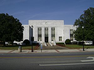
Mitchell County Courthouse (Built 1936), Camilla
|
|

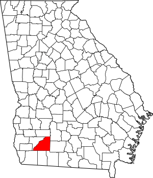
Location within the U.S. state of Georgia
|
|
 Georgia's location within the U.S. |
|
| Country | |
| State | |
| Founded | 1857 |
| Seat | Camilla |
| Largest city | Camilla |
| Area | |
| • Total | 514 sq mi (1,330 km2) |
| • Land | 512 sq mi (1,330 km2) |
| • Water | 1.7 sq mi (4 km2) 0.3%% |
| Population
(2020)
|
|
| • Total | 21,755 |
| • Density | 42/sq mi (16/km2) |
| Time zone | UTC−5 (Eastern) |
| • Summer (DST) | UTC−4 (EDT) |
| Congressional district | 2nd |
Mitchell County is a place in the state of Georgia, USA. In 2020, about 21,755 people lived there. The main town, or county seat, is Camilla. Mitchell County was started on December 21, 1857.
Contents
What's in a Name? The Story of Mitchell County
People have different ideas about how Mitchell County got its name. Some think it was named after David Brydie Mitchell. He was the 27th Governor of Georgia. Others believe it was named for Henry Mitchell. He was a general during the American Revolutionary War.
However, it is most likely named after General Henry Mitchell. A special sign outside the Mitchell County Courthouse says so. It explains that the Georgia laws from 1857 say the county was named in his honor.
A Look Back: Mitchell County's History
Mitchell County was created on December 21, 1857. It was formed from a part of Baker County. This made it the 123rd county in the state of Georgia.
Exploring Mitchell County's Geography
Mitchell County covers a total area of about 514 square miles. Most of this area, about 512 square miles, is land. Only a small part, about 1.7 square miles, is water.
Most of Mitchell County is in the Lower Flint River area. This river basin is part of a larger system called the ACF River Basin. The southeastern part of the county is in the Lower Ochlockonee River area. This area includes towns like Sale City and Pelham.
Roads and Highways in Mitchell County
Many important roads run through Mitchell County. These roads help people travel around the county and to other parts of Georgia.
Neighboring Counties
Mitchell County shares borders with several other counties. These include:
- Dougherty County (north)
- Worth County (northeast)
- Colquitt County (east)
- Thomas County (southeast)
- Grady County (south)
- Decatur County (southwest)
- Baker County (west)
Towns and Cities in Mitchell County
Mitchell County has several communities where people live. These include cities, towns, and smaller unincorporated areas.
Cities
- Baconton
- Camilla
- Meigs (partly in Thomas County)
- Pelham
Towns
Smaller Communities
These are smaller areas that are not officially cities or towns.
Who Lives in Mitchell County?
The population of Mitchell County has changed over the years. Here's a look at how many people have lived there during different census counts:
| Historical population | |||
|---|---|---|---|
| Census | Pop. | %± | |
| 1860 | 4,308 | — | |
| 1870 | 6,633 | 54.0% | |
| 1880 | 9,392 | 41.6% | |
| 1890 | 10,906 | 16.1% | |
| 1900 | 14,767 | 35.4% | |
| 1910 | 22,114 | 49.8% | |
| 1920 | 25,588 | 15.7% | |
| 1930 | 23,620 | −7.7% | |
| 1940 | 23,261 | −1.5% | |
| 1950 | 22,528 | −3.2% | |
| 1960 | 19,652 | −12.8% | |
| 1970 | 18,956 | −3.5% | |
| 1980 | 21,114 | 11.4% | |
| 1990 | 20,275 | −4.0% | |
| 2000 | 23,932 | 18.0% | |
| 2010 | 23,498 | −1.8% | |
| 2020 | 21,755 | −7.4% | |
| 2023 (est.) | 21,114 | −10.1% | |
| U.S. Decennial Census 1790-1880 1890-1910 1920-1930 1930-1940 1940-1950 1960-1980 1980-2000 2010 |
|||
The table below shows the different groups of people living in Mitchell County. The US Census counts people by their race and ethnicity.
| Race / Ethnicity (NH = Non-Hispanic) | Pop 2000 | Pop 2010 | Pop 2020 | % 2000 | % 2010 | % 2020 |
|---|---|---|---|---|---|---|
| White alone (NH) | 11,746 | 10,894 | 10,106 | 49.08% | 46.36% | 46.45% |
| Black or African American alone (NH) | 11,423 | 11,185 | 10,054 | 47.73% | 47.60% | 46.21% |
| Native American or Alaska Native alone (NH) | 41 | 60 | 37 | 0.17% | 0.26% | 0.17% |
| Asian alone (NH) | 61 | 120 | 108 | 0.25% | 0.51% | 0.50% |
| Pacific Islander alone (NH) | 8 | 4 | 0 | 0.03% | 0.02% | 0.00% |
| Other race alone (NH) | 8 | 18 | 41 | 0.03% | 0.08% | 0.19% |
| Mixed race or Multiracial (NH) | 154 | 189 | 445 | 0.64% | 0.80% | 2.05% |
| Hispanic or Latino (any race) | 491 | 1,028 | 964 | 2.05% | 4.37% | 4.43% |
| Total | 23,932 | 23,498 | 21,755 | 100.00% | 100.00% | 100.00% |
In 2020, there were 21,755 people living in Mitchell County. These people lived in 7,982 households. About 5,454 of these were families.
Learning in Mitchell County: Schools and Education
Most public schools in Mitchell County are run by the Mitchell County School District. However, the city of Pelham has its own school system, called the Pelham City School District.
Andersonville Theological Seminary has its main office in Camilla. This school has two buildings for its administration. Most students at the seminary take their classes online. But, in January 2020, the school started offering some classes in person in Camilla.
Famous People from Mitchell County
- George Thornewell Smith - He was a former Lieutenant Governor of Georgia. He also served as a state court judge.
See also
 In Spanish: Condado de Mitchell (Georgia) para niños
 | Kyle Baker |
 | Joseph Yoakum |
 | Laura Wheeler Waring |
 | Henry Ossawa Tanner |


