Worth County, Georgia facts for kids
Quick facts for kids
Worth County
|
|
|---|---|

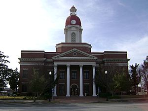
Worth County courthouse in Sylvester
|
|

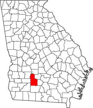
Location within the U.S. state of Georgia
|
|
 Georgia's location within the U.S. |
|
| Country | |
| State | |
| Founded | December 20, 1853 |
| Named for | William J. Worth |
| Seat | Sylvester |
| Largest city | Sylvester |
| Area | |
| • Total | 575 sq mi (1,490 km2) |
| • Land | 571 sq mi (1,480 km2) |
| • Water | 4.1 sq mi (11 km2) 0.7%% |
| Population
(2020)
|
|
| • Total | 20,784 |
| • Density | 36/sq mi (14/km2) |
| Time zone | UTC−5 (Eastern) |
| • Summer (DST) | UTC−4 (EDT) |
| Congressional district | 8th |
Worth County is a county found in the south-central part of Georgia. In 2020, about 20,784 people lived here. The main town and government center is Sylvester. Worth County is part of the larger Albany area.
Contents
History of Worth County
Worth County was formed on December 20, 1853. It was created from parts of Dooly and Irwin counties. This made it the 106th county in Georgia.
Who Was Worth County Named After?
The county was named after Major General William J. Worth. He was a famous military leader from New York. Later, in 1905, some parts of Worth County were used to create Tift and Turner counties.
Geography and Rivers
Worth County covers about 575 square miles. Most of this area, 571 square miles, is land. Only a small part, about 4.1 square miles, is water.
Rivers and Water Basins
The eastern part of Worth County is in the Little River area. This river flows into the Suwannee River. The northern part of the county is in the Middle Flint River area. This river is part of the larger ACF River Basin. A small section in the west is also in the Lower Flint River area. Finally, a part of the southwest is in the Upper Ochlockonee River area.
Major Roads in Worth County
Many important roads run through Worth County. These roads help people travel and connect different communities.
Neighboring Counties
Worth County shares its borders with several other counties in Georgia:
- Crisp County - to the north
- Tift County - to the east
- Turner County - to the northeast
- Colquitt County - to the south
- Mitchell County - to the southwest
- Lee County - to the northwest
- Dougherty County - to the west
Communities in Worth County
Worth County has several towns and cities where people live and work.
Cities in Worth County
Towns in Worth County
Other Communities
These are smaller places that are not officially cities or towns:
- Acree
- Bridgeboro
Population Changes Over Time
The number of people living in Worth County has changed a lot over the years. Here's a look at the population from 1860 to 2020.
| Historical population | |||
|---|---|---|---|
| Census | Pop. | %± | |
| 1860 | 2,763 | — | |
| 1870 | 3,778 | 36.7% | |
| 1880 | 5,892 | 56.0% | |
| 1890 | 10,048 | 70.5% | |
| 1900 | 18,664 | 85.7% | |
| 1910 | 19,147 | 2.6% | |
| 1920 | 23,863 | 24.6% | |
| 1930 | 21,094 | −11.6% | |
| 1940 | 21,374 | 1.3% | |
| 1950 | 19,357 | −9.4% | |
| 1960 | 16,682 | −13.8% | |
| 1970 | 14,770 | −11.5% | |
| 1980 | 18,064 | 22.3% | |
| 1990 | 19,745 | 9.3% | |
| 2000 | 21,967 | 11.3% | |
| 2010 | 21,679 | −1.3% | |
| 2020 | 20,784 | −4.1% | |
| 2023 (est.) | 20,273 | −6.5% | |
| U.S. Decennial Census 1790-1880 1890-1910 1920-1930 1930-1940 1940-1950 1960-1980 1980-2000 2010 |
|||
People Living in Worth County (2020)
In 2020, there were 20,784 people living in Worth County. There were 8,002 households, which are groups of people living together. Also, there were 5,896 families.
This table shows the different groups of people living in Worth County in 2020:
| Race | Num. | Perc. |
|---|---|---|
| White (non-Hispanic) | 14,427 | 69.41% |
| Black or African American (non-Hispanic) | 5,255 | 25.28% |
| Native American | 49 | 0.24% |
| Asian | 87 | 0.42% |
| Pacific Islander | 8 | 0.04% |
| Other/Mixed | 577 | 2.78% |
| Hispanic or Latino | 381 | 1.83% |
See also
 In Spanish: Condado de Worth (Georgia) para niños
 | William M. Jackson |
 | Juan E. Gilbert |
 | Neil deGrasse Tyson |

