Irwin County, Georgia facts for kids
Quick facts for kids
Irwin County
|
||
|---|---|---|

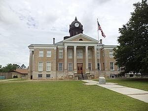
Irwin County Courthouse, Ocilla
|
||
|
||

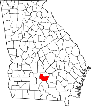
Location within the U.S. state of Georgia
|
||
 Georgia's location within the U.S. |
||
| Country | ||
| State | ||
| Founded | December 15, 1818 | |
| Seat | Ocilla | |
| Largest city | Ocilla | |
| Area | ||
| • Total | 363 sq mi (940 km2) | |
| • Land | 354 sq mi (920 km2) | |
| • Water | 8.4 sq mi (22 km2) 2.3%% | |
| Population
(2020)
|
||
| • Total | 9,666 | |
| • Density | 27/sq mi (10/km2) | |
| Time zone | UTC−5 (Eastern) | |
| • Summer (DST) | UTC−4 (EDT) | |
| Congressional district | 8th | |
Irwin County is a county in the state of Georgia, USA. In 2020, about 9,666 people lived there. The main town and county seat is Ocilla. The county was started on December 15, 1818. It was named after Governor Jared Irwin.
During the last years of the American Civil War, Irwin County was sometimes called the Republic of Irwin. This was because many people living there supported the Union (the North) instead of the Confederacy (the South). The place where Jefferson Davis, the Confederate President, was captured is in Irwin County, near a town called Irwinville.
Contents
History
How Irwin County Started
Irwin County was created on December 15, 1818. It was formed from new land that Georgia received in 1814 and 1818. Over time, many other counties in Georgia were created from parts of Irwin County. These include Cook, Colquitt, Lanier, and Lowndes counties.
When it was first formed, Irwin County was divided into many large sections. Each section was about 490 acres. In 1820, one of these sections cost about $18. By 1831, the price had dropped to $5.
Early Population
In 1820, Irwin County had 372 white people and 39 enslaved people. By 1830, the population grew to 1,066 white people, 109 enslaved people, and 5 free people of color. In 1853 and 1854, parts of Irwin County were used to create Worth County and Coffee County. This made Irwin County smaller. By 1860, there were 1,453 white people and 246 enslaved people in the county.
The Civil War Years
During the American Civil War, people in Irwin County had different ideas. Some supported the Confederacy, while others supported the Union. Irwin County was one of the poorer counties in Georgia at that time. Many people there were Southern Unionists, meaning they were from the South but did not support the Confederacy.
Irwin County sent soldiers to fight for the Confederacy. One group was called Company F "Irwin Volunteers." In 1863, soldiers were sent to Irwin County to find people who had left the Confederate army without permission.
A well-known Union supporter in the county was Willis Jackson Bone. He helped enslaved people who had escaped, soldiers who had left the Confederate army, and Union prisoners who had escaped. He hid them in the swamps along the Alapaha River. In February 1865, Bone and others in Irwinville declared that Irwin County was part of the Union again. They even cheered for Abraham Lincoln, the U.S. President.
Capture of Jefferson Davis
A few months later, in May 1865, Jefferson Davis, the President of the Confederacy, was captured in Irwinville. He was trying to escape from Richmond, Virginia, the Confederate capital, to England. Davis stopped at a hotel in Irwinville on May 9, 1865. He talked with local people, who did not know who he was.
Later, Davis and his family camped near a creek. Early on May 10, they heard gunfire. Davis tried to escape, but soldiers from the First Wisconsin and Fourth Michigan Cavalry Regiments captured him. He was taken to Fort Monroe in Virginia and held for two years. Today, the place where he was captured is a historic site called the Jefferson Davis Memorial Historic Site.
Geography
Land and Water
Irwin County covers a total area of about 363 square miles. Most of this (about 354 square miles) is land. The rest (about 8.4 square miles) is water, which is about 2.3% of the total area.
Most of the county, especially the central and western parts, is in the Alapaha River area. This river flows into the Suwannee River. The eastern part of the county is in the Satilla River area, which flows into the St. Marys River.
Main Roads
Many important roads pass through Irwin County, connecting it to other places.
Neighboring Counties
Irwin County shares borders with several other counties in Georgia:
- Ben Hill County (north)
- Coffee County (east)
- Berrien County (south)
- Tift County (southwest)
- Turner County (northwest)
Education
Students in Irwin County attend schools managed by the Irwin County School District.
People of Irwin County
| Historical population | |||
|---|---|---|---|
| Census | Pop. | %± | |
| 1820 | 411 | — | |
| 1830 | 1,180 | 187.1% | |
| 1840 | 2,038 | 72.7% | |
| 1850 | 3,334 | 63.6% | |
| 1860 | 1,699 | −49.0% | |
| 1870 | 1,837 | 8.1% | |
| 1880 | 2,696 | 46.8% | |
| 1890 | 6,316 | 134.3% | |
| 1900 | 13,645 | 116.0% | |
| 1910 | 10,461 | −23.3% | |
| 1920 | 12,670 | 21.1% | |
| 1930 | 12,199 | −3.7% | |
| 1940 | 12,936 | 6.0% | |
| 1950 | 11,973 | −7.4% | |
| 1960 | 9,211 | −23.1% | |
| 1970 | 8,036 | −12.8% | |
| 1980 | 8,988 | 11.8% | |
| 1990 | 8,649 | −3.8% | |
| 2000 | 9,931 | 14.8% | |
| 2010 | 9,538 | −4.0% | |
| 2020 | 9,666 | 1.3% | |
| 2023 (est.) | 9,120 | −4.4% | |
| U.S. Decennial Census 1790-1880 1890-1910 1920-1930 1930-1940 1940-1950 1960-1980 1980-2000 2010 |
|||
The table below shows the different groups of people living in Irwin County as of 2020.
| Race | Number of People | Percentage |
|---|---|---|
| White (not Hispanic) | 6,402 | 66.23% |
| Black or African American (not Hispanic) | 2,224 | 23.01% |
| Native American | 15 | 0.16% |
| Asian | 119 | 1.23% |
| Pacific Islander | 1 | 0.01% |
| Other/Mixed | 242 | 2.5% |
| Hispanic or Latino | 663 | 6.86% |
In 2020, there were 9,666 people living in Irwin County. These people made up 3,329 households and 2,090 families.
See also
 In Spanish: Condado de Irwin para niños
 | Misty Copeland |
 | Raven Wilkinson |
 | Debra Austin |
 | Aesha Ash |


