Colquitt County, Georgia facts for kids
Quick facts for kids
Colquitt County
|
|
|---|---|

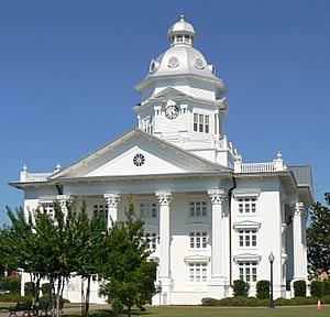
Colquitt County Courthouse in Moultrie
|
|

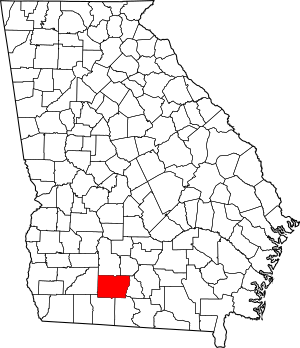
Location within the U.S. state of Georgia
|
|
 Georgia's location within the U.S. |
|
| Country | |
| State | |
| Founded | 1856 |
| Named for | Walter Terry Colquitt |
| Seat | Moultrie |
| Largest city | Moultrie |
| Area | |
| • Total | 557 sq mi (1,440 km2) |
| • Land | 544 sq mi (1,410 km2) |
| • Water | 12 sq mi (30 km2) 2.2%% |
| Population
(2020)
|
|
| • Total | 45,898 |
| • Density | 84/sq mi (32/km2) |
| Time zone | UTC−5 (Eastern) |
| • Summer (DST) | UTC−4 (EDT) |
| Congressional district | 8th |
Colquitt County is a county located in the state of Georgia, in the United States. It's a place where many people live and work.
In 2020, about 45,898 people called Colquitt County home. The main city and county seat is Moultrie. The county was officially created on February 25, 1856. It was named after Walter Terry Colquitt, who was a important U.S. senator.
Contents
About Colquitt County
Colquitt County is part of the Moultrie, GA micropolitan statistical area. This means it's a smaller city area that is still important for jobs and services in the region.
Where is Colquitt County?
Colquitt County is located in the southwestern part of Georgia. It covers a total area of about 557 square miles. Most of this area, 544 square miles, is land. The remaining 12 square miles (about 2.2%) is water.
The county has several rivers and water basins. The western part is near the Ochlockonee River. Other parts are close to the Flint River and the Withlacoochee River. These rivers are important for the local environment and water supply.
Lakes in the County
Colquitt County is home to a couple of lakes:
Main Roads
Several important roads run through Colquitt County, helping people travel around. These include:
 U.S. Route 319
- U.S. Route 319 Business
 State Route 33
 State Route 35
 State Route 37
 State Route 111
 State Route 133
 State Route 202
 State Route 256
 State Route 270
 State Route 270 Spur
Neighboring Counties
Colquitt County shares its borders with several other counties:
- Tift County (to the northeast)
- Cook County (to the east)
- Brooks County (to the southeast)
- Thomas County (to the southwest)
- Mitchell County (to the west)
- Worth County (to the northwest)
Towns and Communities
Colquitt County has several towns and smaller communities where people live.
Cities in Colquitt County
Other Communities
There are also smaller, unincorporated communities in the county:
- Autreyville
- Barbers
- Hartsfield
- Riverside
Population Over Time
| Historical population | |||
|---|---|---|---|
| Census | Pop. | %± | |
| 1860 | 1,316 | — | |
| 1870 | 1,654 | 25.7% | |
| 1880 | 2,527 | 52.8% | |
| 1890 | 4,794 | 89.7% | |
| 1900 | 13,636 | 184.4% | |
| 1910 | 19,789 | 45.1% | |
| 1920 | 29,332 | 48.2% | |
| 1930 | 30,622 | 4.4% | |
| 1940 | 33,012 | 7.8% | |
| 1950 | 33,999 | 3.0% | |
| 1960 | 34,048 | 0.1% | |
| 1970 | 32,200 | −5.4% | |
| 1980 | 35,376 | 9.9% | |
| 1990 | 36,645 | 3.6% | |
| 2000 | 42,053 | 14.8% | |
| 2010 | 45,498 | 8.2% | |
| 2020 | 45,898 | 0.9% | |
| 2023 (est.) | 46,167 | 1.5% | |
| U.S. Decennial Census 1790-18801890-1910 1920-1930 1930-1940 1940-1950 1960-1980 1980-2000 2010 |
|||
The population of Colquitt County has grown a lot since it was founded. In 1860, there were only 1,316 people. By 2020, the population had reached 45,898. This shows how the county has developed over many years.
As of the 2020 census, most people in Colquitt County are White (about 55.75%). A significant number are Black or African American (about 21.78%), and about 18.97% are Hispanic or Latino. There are also smaller groups of Asian, Native American, and other races living in the county.
Schools in Colquitt County
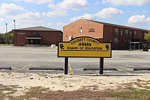
The Colquitt County School District is in charge of the public schools here. Students attend various schools, and the main high school for the area is Colquitt County High School.
See also
 In Spanish: Condado de Colquitt para niños
 | Anna J. Cooper |
 | Mary McLeod Bethune |
 | Lillie Mae Bradford |


