Cook County, Georgia facts for kids
Quick facts for kids
Cook County
|
|
|---|---|

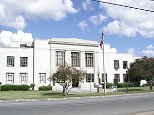
Cook County Courthouse in Adel
|
|

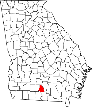
Location within the U.S. state of Georgia
|
|
 Georgia's location within the U.S. |
|
| Country | |
| State | |
| Founded | 1918 |
| Named for | Philip Cook |
| Seat | Adel |
| Largest city | Adel |
| Area | |
| • Total | 233 sq mi (600 km2) |
| • Land | 227 sq mi (590 km2) |
| • Water | 6.0 sq mi (16 km2) 2.6%% |
| Population
(2020)
|
|
| • Total | 17,229 |
| • Density | 76/sq mi (29/km2) |
| Time zone | UTC−5 (Eastern) |
| • Summer (DST) | UTC−4 (EDT) |
| Congressional district | 8th |
Cook County is a special area in the south-central part of Georgia. It is like a local government division. In 2020, about 17,229 people lived here.
The main town and government center is Adel. Cook County was officially created on November 5, 1918. It is named after Philip Cook. He was a general during the American Civil War.
You can find Reed Bingham State Park in Cook County. It is a great place to visit.
Contents
Cook County Geography
Cook County covers a total area of about 233 square miles. Most of this is land, about 227 square miles. The rest, about 6 square miles, is water.
The western part of Cook County has rivers that flow into the Little River. This river then joins the Suwannee River. The eastern part of the county has rivers that flow into the Withlacoochee River. This river also joins the Suwannee River.
Main Roads in Cook County
These are the most important roads that go through Cook County:
 Interstate 75
 U.S. Route 41
 State Route 7
 State Route 37
 State Route 76
 State Route 401 (This is another name for I-75)
Neighboring Counties
Cook County shares its borders with these other counties:
- Tift County (to the north)
- Berrien County (to the east)
- Lowndes County (to the southeast)
- Brooks County (to the southwest)
- Colquitt County (to the west)
Cook County Towns
Here are the main towns and cities in Cook County:
Cook County Population Information
Demographics means information about the people who live in an area. This includes how many people there are and their different backgrounds.
| Historical population | |||
|---|---|---|---|
| Census | Pop. | %± | |
| 1920 | 11,180 | — | |
| 1930 | 11,311 | 1.2% | |
| 1940 | 11,919 | 5.4% | |
| 1950 | 12,201 | 2.4% | |
| 1960 | 11,822 | −3.1% | |
| 1970 | 12,129 | 2.6% | |
| 1980 | 13,490 | 11.2% | |
| 1990 | 13,456 | −0.3% | |
| 2000 | 15,771 | 17.2% | |
| 2010 | 17,212 | 9.1% | |
| 2020 | 17,229 | 0.1% | |
| 2023 (est.) | 17,714 | 2.9% | |
| U.S. Decennial Census 1790-18801890-1910 1920-1930 1930-1940 1940-1950 1960-1980 1980-2000 2010 |
|||
The table below shows the different groups of people living in Cook County in 2020.
| Group | Number of People | Percentage |
|---|---|---|
| White (not Hispanic) | 10,658 | 61.86% |
| Black or African American (not Hispanic) | 4,753 | 27.59% |
| Native American | 29 | 0.17% |
| Asian | 100 | 0.58% |
| Pacific Islander | 4 | 0.02% |
| Other/Mixed | 551 | 3.2% |
| Hispanic or Latino | 1,134 | 6.58% |
In 2020, there were 17,229 people living in Cook County. These people lived in 6,217 homes, and 4,243 of these were families.
Education in Cook County
Schools in Cook County are part of the Cook County School District. This district runs Cook County High School.
See also
 In Spanish: Condado de Cook (Georgia) para niños
 | Janet Taylor Pickett |
 | Synthia Saint James |
 | Howardena Pindell |
 | Faith Ringgold |

