Ben Hill County, Georgia facts for kids
Quick facts for kids
Ben Hill County
|
||
|---|---|---|

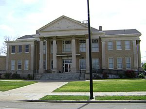
Ben Hill County Courthouse, Fitzgerald
|
||
|
||

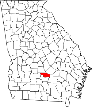
Location within the U.S. state of Georgia
|
||
 Georgia's location within the U.S. |
||
| Country | ||
| State | ||
| Founded | 1906 | |
| Named for | Benjamin Harvey Hill | |
| Seat | Fitzgerald | |
| Largest city | Fitzgerald | |
| Area | ||
| • Total | 254 sq mi (660 km2) | |
| • Land | 250 sq mi (600 km2) | |
| • Water | 3.8 sq mi (10 km2) 1.5%% | |
| Population
(2020)
|
||
| • Total | 17,194 | |
| • Density | 69/sq mi (27/km2) | |
| Time zone | UTC−5 (Eastern) | |
| • Summer (DST) | UTC−4 (EDT) | |
| Congressional district | 8th | |
Ben Hill County is a county in the state of Georgia. In 2020, about 17,194 people lived here. The main town and county seat is Fitzgerald. The county was started in 1906. It is named after Benjamin Harvey Hill. He was a senator for both the Confederate States and the United States.
Ben Hill County is part of the Fitzgerald micropolitan area. This means it's a smaller city area with close ties to Fitzgerald. The Ben Hill County Courthouse and Ben Hill County Jail are important buildings here. They are listed on the National Register of Historic Places because of their history.
Contents
History of Ben Hill County
Ben Hill County was officially formed in 1906. It was created from parts of two other counties. These were Irwin County and Wilcox County.
Geography of Ben Hill County
Ben Hill County covers about 254 square miles. Most of this area is land, about 250 square miles. The rest, about 3.8 square miles, is water.
Most of the county is in the Lower Ocmulgee River area. This river flows into the larger Altamaha River. A small part of the county is in the Alapaha River area. This river flows into the Suwannee River. Another small part is in the Satilla River area. This river flows into the St. Marys-Satilla River system. Ben Hill County is located in the Southeast Georgia region.
Main Roads in Ben Hill County
Neighboring Counties
- Wilcox County - to the north
- Telfair County - to the northeast
- Coffee County - to the east
- Irwin County - to the south
- Turner County - to the west
Towns and Communities
City
- Fitzgerald (This is the county seat, where the main government offices are.)
Other Communities
- Bowen's Mill
- Queensland
Population of Ben Hill County
| Historical population | |||
|---|---|---|---|
| Census | Pop. | %± | |
| 1910 | 11,863 | — | |
| 1920 | 14,599 | 23.1% | |
| 1930 | 13,047 | −10.6% | |
| 1940 | 14,523 | 11.3% | |
| 1950 | 14,879 | 2.5% | |
| 1960 | 13,633 | −8.4% | |
| 1970 | 13,171 | −3.4% | |
| 1980 | 16,000 | 21.5% | |
| 1990 | 16,245 | 1.5% | |
| 2000 | 17,484 | 7.6% | |
| 2010 | 17,634 | 0.9% | |
| 2020 | 17,194 | −2.5% | |
| 2023 (est.) | 17,128 | −2.9% | |
| U.S. Decennial Census 1790-18801890-1910 1920-1930 1930-1940 1940-1950 1960-1980 1980-2000 2010 |
|||
Here's a look at the different groups of people living in Ben Hill County in 2020:
| Race | Num. | Perc. |
|---|---|---|
| White (not Hispanic) | 9,219 | 53.62% |
| Black or African American (not Hispanic) | 6,222 | 36.19% |
| Native American | 57 | 0.33% |
| Asian | 116 | 0.67% |
| Other/Mixed | 526 | 3.06% |
| Hispanic or Latino | 1,054 | 6.13% |
In 2020, there were 17,194 people living in Ben Hill County. There were 6,443 households and 4,019 families.
Most people in Ben Hill County follow Christianity. This area is part of what is known as the Bible Belt. The largest Christian group is the Southern Baptist Convention. The National Baptist Convention, USA is another large Baptist group. The Baha'i Faith is also present in the county.
Education in Ben Hill County
The Ben Hill County School District is in charge of the schools here.
- Ben Hill Preschool
- Ben Hill County Primary School
- Ben Hill County Elementary School
- Ben Hill County Middle School
- Fitzgerald High School
Transportation
The Fitzgerald Municipal Airport is a public airport. It is located about 2 miles southwest of Fitzgerald.
See also
 In Spanish: Condado de Ben Hill para niños
 | Georgia Louise Harris Brown |
 | Julian Abele |
 | Norma Merrick Sklarek |
 | William Sidney Pittman |


